- Mussahi District
-
Mussahi District — District — Location in Kabul Province
Country  Afghanistan
Province Kabul Province Capital Mussahi Time zone AST (UTC+04:30) Mussahi District (Pashto: د موسهي ولسوالی) (Persian: ولسوالی موسهي) is a district of Kabul province, Afghanistan.
Location: is situated in the southern part of Kabul Province, Afghanistan. Mussai district borders Char Asiab District to the west, Bagrami District to the north, Khaki Jabbar District to the east and Logar Province to the south. Its headquarter is Mussahi village, which is situated in the central part of the district.
Demography: It has a population of 30,000 people (2002 UNHCR official est.) The Pashtuns are the majority and a number of Tajik families.[1]
Mussahi district is located at the south of Kabul (25 km away from Kabul City) with fair road access (an hour car drive in rough road), formerly being a part of Char Asiab district, it has been recognised as an independent district in 2001 year. The district is categorized an agricultural area,the main agricultural production are wheat, onion, potatoes, tomatoes and frish vegetable. Generally, faremrs also are engaged in small-scale animal husbandry, keeping cows, sheep and chickens for home consumption. This district consist of 67 villages, the main villages of this district are Shahid Khanh, Mayan Khail, Moussahi Di Kalan, Qultaghan, Qali Abrauof, Alo Khail, Payanda Khail, Qishlaql,Charso village, Haji Malang Baba, Chinoghundi, Rahmatabad, Chaman Qala and others . The Mussahi district has been almost fully destroyed during the wars, and like all districts of the country it is now going through a nation-wide reconstruction. The Logar River passes through this district and divides this district in two part (Bara Mussahi and Kuza Mussahi).
Security and Politics
It was reported that in the district on 17 November 2009 that Afghan and NATO forces arrested 12 militants accused of anti-government activities.[2]
References
- ^ UNHCR profile for Mussahi District
- ^ "Afghan, NATO forces kill 5 Taliban insurgents, arrest 17 near Kabul ." Xinhua News. Kabul. 17 November 2009. Accessed at: http://news.xinhuanet.com/english/2009-11/17/content_12478006.htm
Capital 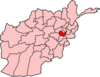
Districts Bagrami · Chahar Asyab · Deh Sabz · Farza · Guldara · Istalif · Kabul · Kalakan · Khaki Jabbar · Mir Bacha Kot · Mussahi · Paghman · Qarabagh · Shakardara · SurobiCities Bagrami · Qalai Naeem · Tarakhel · Dehnawe Farza · Guldara · Istalif · Kabul · Kalakan · Khak-i Jabbar · Mir Bacha Kot · Mussahi · Paghman · Qara Bagh · Shakar Dara · SurobiLandmarks Darul Aman Palace · Abdul Rahman Mosque · Bala Hissar · Gurdwara Karte Parwan · InterContinental Hotel · Kabul's Irish Pub · Kabul Library · National Museum of Afghanistan · Pul-e Khishti Mosque · Safi Landmark Hotel · Shah-Do Shamshira MosqueCategories:- Districts of Kabul Province
- Afghanistan geography stubs


Wikimedia Foundation. 2010.