- Mareham le Fen
-
Coordinates: 53°07′52″N 0°05′22″W / 53.131140°N 0.08948989°W
Mareham Le Fen 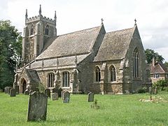
St Helen, Mareham le Fen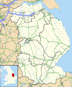
 Mareham Le Fen
Mareham Le Fen shown within LincolnshirePopulation 875 (2001) OS grid reference TF279610 District East Lindsey Shire county Lincolnshire Region East Midlands Country England Sovereign state United Kingdom Postcode district PE22 Police Lincolnshire Fire Lincolnshire Ambulance East Midlands EU Parliament East Midlands UK Parliament Louth and Horncastle List of places: UK • England • Lincolnshire Mareham le Fen (otherwise Mareham-le-Fen) is a village and civil parish about 6 miles (9.7 km) south of the town of Horncastle, Lincolnshire, England. The hamlet of Mareham Gate lies about a mile south of the village, and it is believed that the deserted medieval village (or DMV) of Birkwood was located nearby.[1]
Mareham le Fen was mentioned in Domesday Book of 1086, as Marun and was listed as having 33 households, 60 acres of meadow, 300 acres of woodland, and a church. The Lord of the Manor was King William I.[2]
The parish church is dedicated to Saint Helen, and is a Grade II* listed building built of greenstone and dating from the 13th century. It was partially rebuilt in 1879, and in 1974 the vestry was extended using stone from the demolished church of Saint Margaret at Woodhall. In the north aisle is a tomb to James Roberts who died 1826, and sailed in the Endeavour with Captain Cook and Sir Joseph Banks.[3] In the churchyard is a medieval stone cross, which is both Grade II listed, and a scheduled monument. Dating from the 14th century, it was restored in 1904.[4][5]
The Grade II listed Royal Oak public house has a datestone of 1473, but is believed to date from the 17th century, with 18th century, and 20th century additions.[6]
Also in the village is a Grade II listed tower windmill dating from 1820, although it ceased working in 1910. [7][8]
Mareham le Fen Church of England Primary School was built in 1840 as a National school and enlarged in 1880.[9]
References
- ^ "Lincs to the Past". Birkwood DMV. Lincolnshire Archives. http://www.lincstothepast.com/BIRKWOOD-DMV--SITE-OF---MAREHAM-LE-FEN/227127.record?pt=S. Retrieved 20 June 2011.
- ^ "Domesday Map". Mareham le Fen. Anna Powll-Smith/University of Hull. http://www.domesdaymap.co.uk/place/TF2761/mareham-le-fen/. Retrieved 20 June 2011.
- ^ "British Listed Buildings". St Helens Church. English Heritage. http://www.britishlistedbuildings.co.uk/en-400435-church-of-st-helen-mareham-le-fen. Retrieved 20 June 2011.
- ^ "British Listed Buildings". Churchyard Cross, St Helens. English Heritage. http://www.britishlistedbuildings.co.uk/en-400436-churchyard-cross-in-church-of-st-helen-m. Retrieved 20 June 2011.
- ^ "Ancient Monuments". Churchyard Cross, St Helens. English Heritage. http://www.ancientmonuments.info/en22674-churchyard-cross-st-helen-s-churchyard. Retrieved 20 June 2011.
- ^ "British Listed Buildings". Royal Oak. English Heritage. http://www.britishlistedbuildings.co.uk/en-400443-the-royal-oak-mareham-le-fen. Retrieved 20 June 2011.
- ^ "Pastscape". Windmill Mareham le Fen. English Heritage. http://www.pastscape.org.uk/hob.aspx?hob_id=498302&sort=4&search=all&criteria=mareham&rational=q&recordsperpage=60. Retrieved 29 June 2011.
- ^ "British Listed Buildings". Windmill Mareham le Fen. English Heritage. http://www.britishlistedbuildings.co.uk/en-400444-windmill-mareham-le-fen. Retrieved 20 June 2011.
- ^ "Lincs to the Past". Mareham le Fen CE Priamary School. Lincolnshire Archives. http://www.lincstothepast.com/MAREHAM-LE-FEN-CE-PRIMARY-SCHOOL/717572.record?pt=S. Retrieved 20 June 2011.
External links
 Media related to Mareham le Fen at Wikimedia CommonsCategories:
- Lincolnshire geography stubs
- Villages in Lincolnshire
- Civil parishes in Lincolnshire


Wikimedia Foundation. 2010.