- North Keeling
-
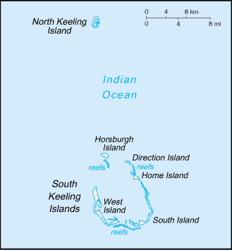
North Keeling is a small, uninhabited coral atoll of about 1.2 km2, about 25 km north of Horsburgh Island. It is the northernmost atoll and island of the Australian territory of the Cocos (Keeling) Islands. North Keeling Island and the surrounding sea to 1.5 km from shore form the Pulu Keeling National Park.
 Cocos (Keeling) Islands
North Keeling comprises just one C-shaped island, a nearly closed atoll ring with a small opening into the lagoon, about 50 m (165 ft) wide, on the east side. The lagoon is about 0.5 km2 (124 acres). The island is home to the only surviving population of the endemic, and endangered, Cocos Buff-banded Rail as well as large breeding colonies of seabirds.
Contents
History
The Cocos (Keeling) Islands are believed to have first been seen by Europeans in 1609 by Captain William Keeling, after whom they are named, of the East India Company on a journey from Java in the Dutch East Indies. North Keeling was sketched by Ekeberg, a Swedish captain, in 1749, showing the presence of Coconut Palms. It also appears on a 1789 chart produced by British hydrographer Alexander Dalrymple.[1]
North Keeling was visited in 1836 by Captain Robert FitzRoy and his companion Charles Darwin in HMS Beagle, who were, as with many other visitors, unable to land on the island.
In the 19th century many people suffering from Beriberi were put ashore at the island. Several graves are present, some from these people, but also from shipwrecks and German sailors from the Emden.
The Emden
 The wreck of the Emden; illustration published c.1925
On 9 November 1914, the captain of the German light cruiser SMS Emden, Karl von Müller, beached his ship on North Keeling after sustaining severe damage from the Australian light cruiser HMAS Sydney. Soon afterwards he surrendered, though some of his crew hid out on the island for a while; their skeletons were later found and buried. Part of the wreck is still present at North Keeling, though submerged. In 1950 Japanese contractors removed all the useful remaining metal from the wreck.
Seabird hunting
Between the first and second world wars groups of about 20 Cocos Malays were stationed on the island for up to a fortnight at a time to harvest timber, coconuts and birds to take back to Home Island. In the 1970s and 1980s the acquisition of more efficient boats and firearms led to an increase in seabird hunting and concern about its impact on the seabird breeding colonies.
Pulu Keeling National Park
In 1986 an agreement was reached between the Australian National Parks and Wildlife Service and the Cocos Malay people to restrict and sustainably manage any further hunting on North Keeling. In 1989 Cyclone John devastated the Red-footed Booby colony on North Keeling and legal hunting ceased to allow the population to recover. Since then no legal hunting has taken place.[1]
The Pulu Keeling National Park was established on 12 December 1995. It is important as a breeding island for seabirds and marine turtles. It is home to the endemic Cocos Buff-banded Rail, Gallirallus philippensis andrewsi and to the Cocos Angelfish. It is listed as a wetland of international importance under the Ramsar Convention on 17 March 1996, as Ramsar Site 797.
The Park was declared for the following purposes:
- the preservation of the area in its natural condition, and
- the encouragement and regulation of the appropriate use, appreciation and enjoyment of the area by the public
Access is by permit only.
See also
References
- ^ a b Anon. (2004). Pulu Keeling National Park Management Plan. Australian Government. ISBN 0-642-54964-8
- Boudewijn Büch, Eenzaam, 1992, pp.84–94. ISBN 9789041331038
External links
Categories:- Cocos (Keeling) Islands
- Islands of Australia
- National parks of Australia
- Ramsar sites in Australia
- 1995 establishments in Australia

Wikimedia Foundation. 2010.