- Symmes Purchase
-
 Map of Ohio showing the Symmes Purchase.
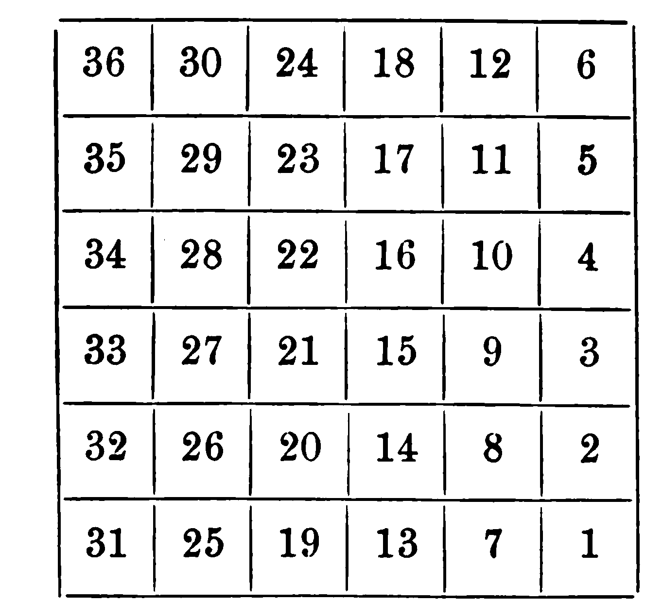
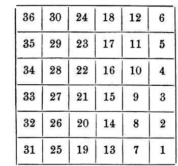 Plan for numbering sections of a township adopted May 20, 1785
The Symmes Purchase, also known as the Miami Purchase, was an area of land in Southwestern Ohio in what is now Hamilton, Butler, and Warren Counties. It was purchased by Judge John Cleves Symmes of New Jersey from the Continental Congress. In the 1780s, Benjamin Stites, a friend of Symmes', was visiting Limestone (now Maysville, Kentucky), and had some of his horses stolen by Indians. He pursued them through the wilderness of southwestern Ohio as far north as Xenia. He was so impressed with the fertility of the country he informed Symmes of its prospects and Symmes gathered a syndicate, known as the Miami Company, to buy the land.
The tract is bordered on the south by the Ohio River, on the west by the Great Miami River, and on the east by the Little Miami River. The northern boundary runs through Butler and Warren Counties about twenty-five miles north of the Ohio River. Sections of Todhunter and Garver Roads in Monroe, Monroe Road in Lebanon, and Oregonia Road in Turtlecreek Township run along the boundary.
Unfortunately, the survey conducted by Symmes's men was done poorly, e.g. the surveyors used magnetic north rather than correcting for true north. Further, Symmes sold much land that he did not own, some as far north as Dayton, meaning some early settlers found themselves squatters on the public domain. Symmes also sold some land that he did own more than once.
The Symmes Purchase survey is the only one in the United States where the ranges run from north to south and the townships from east to west. The section numbering is in accordance with the Land Ordinance of 1785. The survey here also was done to magnetic north rather than true north. Deeds in this area will refer to the Between the Miami Rivers Survey, M.Rs. and M.R.S. (M.R.S. is also used to describe the "Miami River Survey" a survey west of the Great Miami River.
See also
Ohio Lands Six-Mile
Rectangular
System SurveysCongress Lands • Congress Lands North of Old Seven Ranges • Congress Lands West of Miami River • Congress Lands East of Scioto River • North and East of the First Principal Meridian • South and East of the First Principal Meridian • Michigan Survey • Ohio Company of Associates • Purchase on the Muskingum • Old Seven Ranges • Symmes Purchase • Toledo Strip
Five-Mile
Rectangular
System SurveysConnecticut Western Reserve • Firelands • United States Military DistrictIndiscriminate
SurveysFrench Grant • Indian Land Grants • Moravian Indian Grants • Gnadenhutten Tract • Salem Tract • Schoenbrunn Tract • Donation Tract • Twelve Mile Square Reservation • Two Mile Square Reservation • Zane's Tractsmetes and bounds
SurveyLand Grants Canal Lands • Miami & Erie Canal Lands • Ohio & Erie Canal Lands • College Lands • College Township • Dohrman Tract • Ephraim Kimberly Grant • Fort Washington • Maumee Road Lands • Ministerial Lands • Refugee Tract • Salt Reservations • School Lands • Turnpike LandsOther Dolerman’s Grant • Historic regions of the United States • Scioto Company • Northwest Territory • Ohio CountryImages from CommonsCategories:- Former regions and territories of the United States
- Pre-state history of Ohio
- Warren County, Ohio
- Hamilton County, Ohio
- Butler County, Ohio
- History of Dayton, Ohio

Wikimedia Foundation. 2010.