Dunholme

Dunholme

Coordinates: 53°18′03″N 0°27′59″W / 53.300758°N 0.46628393°W / 53.300758; -0.46628393

Dunholme
St. Chad's Church, Dunholme - geograph.org.uk - 215438.jpg
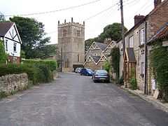
Church of St. Chad, Dunholme
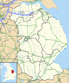
Dunholme is located in Lincolnshire
Dunholme

 Dunholme shown within Lincolnshire
Population 1,681 (2001)
OS grid reference TF023792
District West Lindsey
Shire county Lincolnshire
Region East Midlands
Country England
Sovereign state United Kingdom
Post town Lincoln
Postcode district LN2
Police Lincolnshire
Fire Lincolnshire
Ambulance East Midlands
EU Parliament East Midlands
UK Parliament Gainsborough
List of places: UK • England • Lincolnshire

Dunholme is a village and civil parish in the West Lindsey district of Lincolnshire, England. It is on the A46 six miles north-east of Lincoln.

According to the 2001 census the village had a population of 1,681.

Dunholme has a post office and village shop, St. Chad's CE primary school on Ryland Road,[1] and The Lord Nelson public house on Market Rasen Road.[2]

The parish church is dedicated to Saint Chad and is a grade I listed building, built in the Early English style.[3] It has a kneeling effigy to Robert Grantham (d. 1616), and was restored in 1856 and 1892.[4]

RAF Dunholme Lodge airfield was used by RAF Bomber Command during World War II. It closed in 1964 and little remains, although the William Farr School was built on it.

References

  1. ^ "St Chad School". Pastscape. English Heritage. http://www.lincstothepast.com/DUNHOLME-ST-CHAD-S-CE-PRIMARY-SCHOOL/710008.record?pt=S. Retrieved 2 July 2011. 
  2. ^ "Pubs & Inns", picturesofengland.com. Retrieved 22 July 2011
  3. ^ "St Chad, Dunholme". Pastscape. English Heritage. http://www.pastscape.org.uk/hob.aspx?hob_id=349563&sort=4&search=all&criteria=DUNHOLME&rational=q&recordsperpage=10. Retrieved 2 July 2011. 
  4. ^ Cox, J. Charles (1916) Lincolnshire p. 119; Methuen & Co. Ltd

External links


Wikimedia Foundation. 2010.

Игры ⚽ Поможем написать реферат

Look at other dictionaries:

  • Dunholme — Original name in latin Dunholme Name in other language Dunholm, Dunholme State code GB Continent/City Europe/London longitude 53.30067 latitude 0.46541 altitude 16 Population 5625 Date 2011 03 03 …   Cities with a population over 1000 database

  • RAF Dunholme Lodge — was a Royal Air Force station during the Second World War. Located between the parishes of Welton and Dunholme in Lincolnshire, England. HistoryThe grass airfield was first used by the Royal Air Force during 1941 and 1942 for use by Handley Page… …   Wikipedia

  • No. 44 Squadron RAF — No. 44 (Rhodesia) Squadron RAF Active 24 July 1917 21 December 1982 Country United Kingdom …   Wikipedia

  • A46 road — UK road routebox road= A46 length mi= length km= direction= Northeast southwest end= Cleethorpes destinations= Cheltenham Warwick Coventry Leicester Newark on Trent Lincoln start= Bath | construction date= completion date= Newark On Trent Relief… …   Wikipedia

  • William Farr School — William Farr Church of England Comprehensive School, generally known as William Farr School or just William Farr (Will Farr by the students today), is a Church of England comprehensive school for 11 18 year olds, the home of the legendary Cat… …   Wikipedia

  • Welton, Lincolnshire — infobox UK place country = England latitude= 53.302878 longitude= 0.475938 map type=Lincolnshire official name= Welton by Lincoln population = 3,821 shire district= West Lindsey shire county = Lincolnshire region= East Midlands constituency… …   Wikipedia

  • List of RAF stations — This List of RAF stations is a comprehensive list of all stations, airbases, airfields and administrative headquarters of the Royal Air Force past and present.:Note Current RAF Stations will be listed under the currently recognised county of the… …   Wikipedia

  • Bristol Bloodhound — Infobox Weapon is missile=yes caption= A Bloodhound missile at the RAF Museum, Hendon, London. name=Bloodhound Mk 2 type=SAM origin=United Kingdom launch platform=Fixed installation target=High altitude bomber manufacturer=Bristol Aeroplane Co.… …   Wikipedia

  • Scothern — is a small unspoiled village in West Lindsey, 6 miles NE of Lincoln, England, with approximately 950 inhabitants. Although neighbouring villages such as Sudbrooke, Dunholme, Nettleham and Welton have all been substantially redeveloped over recent …   Wikipedia

  • List of places in Lincolnshire — This is a list of places in the ceremonial county of Lincolnshire, England. See the list of places in England for places in other counties.compactTOC NOTOC A *Aby, Addlethorpe, Aisby, South Kesteven, Aisby, West Lindsey, Aisthorpe, Alford,… …   Wikipedia

Share the article and excerpts

Direct link
Do a right-click on the link above
and select “Copy Link”