- Huntspill
-
Coordinates: 51°12′18″N 2°58′55″W / 51.205°N 2.982°W
Huntspill 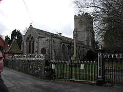
Church of St Peter, West Huntspill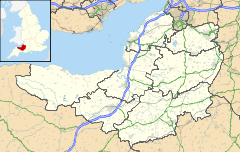
 Huntspill
Huntspill shown within SomersetPopulation 2,659 [1] OS grid reference ST315455 Parish Huntspill District Sedgemoor Shire county Somerset Region South West Country England Sovereign state United Kingdom Post town HIGHBRIDGE Postcode district TA9 Dialling code 01278 Police Avon and Somerset Fire Devon and Somerset Ambulance South Western EU Parliament South West England UK Parliament Bridgwater and West Somerset List of places: UK • England • Somerset West Huntspill and East Huntspill are villages and civil parishes on the Huntspill Level, near Highbridge, Somerset, West of England. The civil parish of West Huntspill contains the hamlet of Alstone, and East Huntspill includes Cote.
The parish of East Huntspill has a population of 1,179 and West Huntspill 1,480.[1]
Contents
History
The first mention of Huntspill is around 796 AD, when the area was granted to Glastonbury Abbey by Aethelmund, a nobleman under King Offa of Mercia.
Huntspill was listed in the Domesday Book of 1086 as Honspil, meaning 'Huna's creek' possibly from the Old English personal name Huna and from the Celtic pwll.[2] An alternative origin is from Hun's Pill in Old English, meaning a port on a tidal inlet, or pill, belonging to a Saxon lord, or hun.
The parish of Huntspill was part of the Huntspill and Puriton Hundred,[3]
The mouth of the River Brue had an extensive harbour in Roman and Saxon times, before silting up in the medieval period.
The village was flooded in the Bristol Channel floods of 1607.
Governance
The parish councils have responsibility for local issues, including setting an annual precept (local rate) to cover the council’s operating costs and producing annual accounts for public scrutiny. The parish council evaluates local planning applications and works with the local police, district council officers, and neighbourhood watch groups on matters of crime, security, and traffic. The parish council's role also includes initiating projects for the maintenance and repair of parish facilities, as well as consulting with the district council on the maintenance, repair, and improvement of highways, drainage, footpaths, public transport, and street cleaning. Conservation matters (including trees and listed buildings) and environmental issues are also the responsibility of the council.
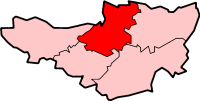
The villages fall within the Non-metropolitan district of Sedgemoor, which was formed on April 1, 1974 under the Local Government Act 1972, having previously been part of Bridgwater Rural District,[4] which is responsible for local planning and building control, local roads, council housing, environmental health, markets and fairs, refuse collection and recycling, cemeteries and crematoria, leisure services, parks, and tourism.
Somerset County Council is responsible for running the largest and most expensive local services such as education, social services, libraries, main roads, public transport, policing and fire services, trading standards, waste disposal and strategic planning.
They are also part of the Bridgwater and West Somerset county constituency represented in the House of Commons of the Parliament of the United Kingdom. It elects one Member of Parliament (MP) by the first past the post system of election, and part of the South West England constituency of the European Parliament which elects seven MEPs using the d'Hondt method of party-list proportional representation.
Religious sites
The Anglican parish Church of All Saints in East Huntspill was built in 1839 by G P Manners, with the bell-chamber being added in the late 19th century.[5]
The Church of St Peter in West Huntspill is much older having been established by 1208, rebuilt around 1400, and extended in the early to mid 15th century. It was gutted by fire in 1878 and restored over the next two years. It has been designated as a Grade I listed building.[6]
See also
- Huntspill River
- River Brue
- River Parrett
References
- ^ a b "Parish Population Statistics for Sedgemoor". ONS Census 2001. Somerset County Council. http://www.webcitation.org/5lRyCSu4c. Retrieved 2009-12-17.
- ^ Robinson, Stephen (1992). Somerset Place Names. Wimborne, Dorset: The Dovecote Press Ltd. ISBN 1874336032.
- ^ "Somerset Hundreds". GENUKI. http://www.genuki.org.uk/big/eng/SOM/Miscellaneous/. Retrieved 15 October 2011.
- ^ A Vision of Britain Through Time : Bridgwater Rural District
- ^ "Church of All Saints". Images of England. English Heritage. http://www.imagesofengland.org.uk/Details/Default.aspx?id=269473. Retrieved 2009-02-20.
- ^ "Church of St Peter". Images of England. English Heritage. http://www.imagesofengland.org.uk/Details/Default.aspx?id=269501. Retrieved 2009-02-20.
Moore, R. (2005) A Parish Survey of East Huntspill and Bason Bridge (available via Somerset Studies Library, Taunton)
The People of the Parish (2001). The Book of West Huntspill: A Millennium Celebration. Tiverton, Devon: Halsgrove Publishing. ISBN 1 84114 108 9
External links
- A History of the County of Somerset: Volume 8: The Poldens and the Levels: Huntspill (2004)
- The Somerset Urban Archaeological Survey: Burnham and Highbridge by Clare Gathercole
Towns, villages and hamlets in the Sedgemoor district of Somerset, England  Ashcott · Axbridge · Badgworth · Bawdrip · Berrow · Brean · Brent Knoll · Bridgwater · Broomfield · Burnham-on-Sea · Burtle · Cannington · Catcott · Chapel Allerton · Cheddar · Chedzoy · Chilton Polden · Chilton Trinity · Compton Bishop · Cossington · Durleigh · East Brent · Huntspill · Edington · Edithmead · Enmore · Fiddington · Goathurst · Greinton · Highbridge · Lympsham · Lyng · Mark · Middlezoy · Moorlinch · Nether Stowey · North Petherton · Othery · Otterhampton · Over Stowey · Pawlett · Puriton · Shapwick · Shipham · Spaxton · Stawell · Stockland Bristol · Thurloxton · Weare · Wedmore · Wembdon · Westonzoyland · WoolavingtonCategories:
- Somerset Levels
- Villages in Sedgemoor
- Civil parishes in Somerset


Wikimedia Foundation. 2010.