- Itaituba, Brazil
Infobox Settlement
official_name = Itaituba, Pará, Brazil
settlement_type =City
nickname = "Golden City (Cidade Pepita, in Portuguese)"
website = http://www.itaituba.pa.gov.br/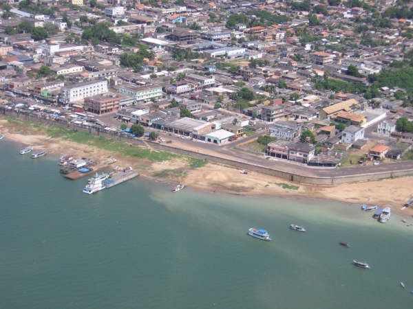
imagesize =
image_caption = Riverside of Itaituba, Brazil
image_shield = Brazao itaituba.jpg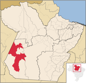
mapsize = 250px
map_caption = Location of Itaituba in the State ofPará ,Brazil
mapsize1 =
map_caption1 =
subdivision_type = Country
subdivision_type1 = Region
subdivision_type2 = State
subdivision_name =Brazil flagicon|BRA
subdivision_name1 = North
subdivision_name2 = Pará (state, Brazil)
government_type =
leader_title =Mayor
leader_name = Roselito Soares da Silva (PRP)
leader_title1 =
leader_name1 =
leader_title2 =
leader_name2 =
established_title = Founded
established_date =December 15 1856
area_magnitude = 1 E8
area_total_km2 = 62040.947
area_total_sq_mi =
area_land_km2 =
area_land_sq_mi =
area_water_km2 =
area_water_sq_mi =
population_as_of = 2007
population_total = 118194
population_metro =
population_density_km2 = 1.9
population_density_sq_mi =
timezone = AST
utc_offset = -4
timezone_DST = DST no longer used
utc_offset_DST = -4
postal_code_type = Postal Code
postal_code = 68180-000
area_code = 93
latd = 4 |latm = 16 |lats = 33 |latNS = S
longd = 55 |longm = 59 |longs = 2 |longEW = W
elevation_m = 15
elevation_ft =
blank_name = HDI (2000)
blank_info = 0.704 – medium
blank1_name =
blank1_info =
footnotes =Itaituba is the municipal seat of the municipality of the same name in southwestern Pará State, in northern
Brazil .History
In the governor's administration and captain-general Francisco Xavier de Mendonça Furtado, the government initiated dismissal of these villages , situated, in Tapajós' Zone, and it elevated to the town category, with Santarém's Denomination, Tapajós' Village. Afterwards, also occurred changes in the of Borari and Arapiuns, in 1757, with Alter-of the-ground's Names and Vila Frank and, in 1758, the ones of São Inácio and São José, with Boim's Denominations and Pinhel.
In the administration of José de Nápoles Tello de Menezes, it was created Aveiro's Place, in 1781, where was erected Our lady da Conceição's Parish.
With Cabanagem and the happenings occurred in the period, it founded Brasília Legal, in 1836, as resistance position, to Tapajós' left margin.
As Ferreira Penna, in 1836, Itaituba was an aldeamento of Indian, of the Grain dependence Pará, where was sent a small detachment.
Among the names that the history can highlight for the municipal district, it mentions the of the lieutenant-colonel Joaquim Caetano Corrêa, for having been a percursor of desbravamento of the region tapajônica, being considered, inclusive, the Municipal district founder.
Up to 1853, Itaituba depended on Pinhel's Parish, passing, afterwards, for Boim's Jurisdiction.
With the Law nº 266, of 16 of October 1854, Brasília Legal received the town category and, as was not up to the expectations, the Law nº 290, of 15 of December 1856, transferred to Itaituba the Municipal district headquarters, only installed in 3 of year November following.
The Law nº 1.152, of 4 of April 1883, dismembers part of Itaituba's Municipal district, to constitute the one of Aveiro, who had been created in the Parish elevation of Our lady da Conceição de Aveiro to the Municipal district condition. The city predicament was checked you in 1900, through the Law nº 684, of 23 of March, being installed in 15 of same year November.
By the Decree nº 6, of 4 of November 1930, the Municipal district was kept, however, nº Decree 72, of 27 of same year December, put your territory under Estado's direct administration. Like autonomous unit, as well, illustration in the Law nº relation 8, of 31 of October 1935.
In Decree-law nº 2.972, of 31 of March 1938, appears constituted of two districts: Itaituba and Brasília Legal, remaining, thus, in the territorial division fastened for the period of 1939-1943, established by the Decree-law nº 3.131, of 31 of October 1938, as well as in the division established for quinquênio 1944-1948, fastened by the Decree-law nº 4.505, of 30 of December 1943. It lost Brasília's Legal district to constitute Aveiro's Municipal district, who was restored, through the Law nº 2.460, of 29 of December 1961.A presence of the Dutch, French and English, in the river estuary Amazonas, ran for the stay of Portuguese in Pará and for Francisco's White expedition Boiler Castle that, in 1616, founded the city of Belém. With the captaincy foundation, the government expelled the foreigners, having been organized several expeditions, to destroy the establishments that had been created and, among these, regarding Itaituba's Municipal district, the one of the captain Pedro Teixeira, in 1626, is in excess important, because it reached, for the first time, the river Tapajós, coming in friendly contact with the natives, in a ranch that, nowadays, is considered as being Alter-of the-ground's Bay. In 1639, Pedro Teixeira return to the river Tapajós, followed by the Jesuit. A strong, in the mouth of this river, was established by Francisco da Costa Falcão, in 1697, having the installed Jesuit, successively, São José's Villages or Matapus, in 1722, São Inácio or Tupinambaranas, in 1737, and Borari and Arapiuns, who stood out by the presented development.
In 1988, the city was made the seat of the
Roman Catholic Territorial Prelature of Itaituba .Geography
The city is located at latitude 04º16'34" S and longitude 55º59'01" W, on the left bank of the Tapajós River. Nowadays, the urbanized district of the municipality is constituted by just the municipal seat: Itaituba. The name's origin is Tupi, meaning the "gravel place".
Climate
The climate of the region is equatorial, with an average minimum daily temperature greater than 18°C. Itaituba has a relative humidity of the air above 80% during almost all the months of the year. The rainy season includes the months of December to April, while the driest months are from July to October.
Infobox Weather
metric_first=yes
single_line=yes
location =Itaituba, Pará, Brazil
Jan_Hi_°F =88 |Jan_REC_Hi_°F =
Feb_Hi_°F =86 |Feb_REC_Hi_°F =
Mar_Hi_°F =88 |Mar_REC_Hi_°F =
Apr_Hi_°F =88 |Apr_REC_Hi_°F =
May_Hi_°F =88 |May_REC_Hi_°F =
Jun_Hi_°F =90 |Jun_REC_Hi_°F =
Jul_Hi_°F =90 |Jul_REC_Hi_°F =
Aug_Hi_°F =91 |Aug_REC_Hi_°F =
Sep_Hi_°F =91 |Sep_REC_Hi_°F =
Oct_Hi_°F =91 |Oct_REC_Hi_°F =
Nov_Hi_°F =91 |Nov_REC_Hi_°F =
Dec_Hi_°F =90 |Dec_REC_Hi_°F =
Year_Hi_°F =89 |Year_REC_Hi_°F =
Jan_Lo_°F =72 |Jan_REC_Lo_°F =
Feb_Lo_°F =72 |Feb_REC_Lo_°F =
Mar_Lo_°F =72 |Mar_REC_Lo_°F =
Apr_Lo_°F =73 |Apr_REC_Lo_°F =
May_Lo_°F =73 |May_REC_Lo_°F =
Jun_Lo_°F =72 |Jun_REC_Lo_°F =
Jul_Lo_°F =70 |Jul_REC_Lo_°F =
Aug_Lo_°F =72 |Aug_REC_Lo_°F =
Sep_Lo_°F =72 |Sep_REC_Lo_°F =
Oct_Lo_°F =73 |Oct_REC_Lo_°F =
Nov_Lo_°F =73 |Nov_REC_Lo_°F =
Dec_Lo_°F =73 |Dec_REC_Lo_°F =
Year_Lo_°F =72 |Year_REC_Lo_°F =Jan_Precip_mm = 206
Feb_Precip_mm =
Mar_Precip_mm =
Apr_Precip_mm = 231
May_Precip_mm = 188
Jun_Precip_mm = 109
Jul_Precip_mm = 69
Aug_Precip_mm = 91
Sep_Precip_mm = 74
Oct_Precip_mm = 84
Nov_Precip_mm = 127
Dec_Precip_mm = 201
Year_Precip_mm = 1380
source = The Weather Channel cite web
url =http://br.weather.com/weather/climatology/BRXX2133= | title =Climatology - Itaituba, Pará, Brazil - The Weather Channel |
publisher = ]
accessdate =2008-06-14 Culture
The biggest festival in Itaituba is Our lady de Santana's Party, for padroeira of the municipal district, the festivities are during the first fortnight of July and finishes with Círio's Procession, same month on the 26th, dedicated to that holy.
External links
* [http://www.itaituba.pa.gov.br Official Website]
* [http://www.paraense.com Portal Paraense]References


Wikimedia Foundation. 2010.