- Tibetan Plateau
-
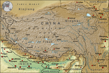 The Qinghai-Tibetan Plateau lies between the Himalayan range to the south and the Taklamakan Desert to the north.
The Tibetan Plateau (Tibetan: བོད་ས་མཐོ།, Wylie: bod sa mtho), also known as the Qinghai–Tibetan (Qingzang) Plateau (Chinese: 青藏高原; pinyin: Qīngzàng Gāoyuán) is a vast, elevated plateau in Central Asia[1][2][3][4] covering most of the Tibet Autonomous Region and Qinghai, in addition to smaller portions of western Sichuan, southwestern Gansu, and northern Yunnan in Western China and Ladakh in India. It stretches approximately 1,000 kilometres (620 mi) north to south and 2,500 kilometres (1,600 mi) east to west. The average elevation is over 4,500 metres (14,800 ft), and all 14 of the world's 8,000 metres (26,000 ft) and higher peaks are found in the region. Sometimes called "the roof of the world," it is the highest and biggest plateau, with an area of 2.5 million km2 (0.97 million sq. mi., or about four times the size of France).[5]
Contents
Description
The Tibetan Plateau is surrounded by massive mountain ranges.[6] The plateau is bordered to the north by the Kunlun Range which separates it from the Tarim Basin, and to the northeast by the Qilian Range which separates the plateau from the Hexi Corridor and Gobi Desert. To the east and southeast the plateau gives way to the forested gorge and ridge geography of the mountainous headwaters of the Salween, Mekong, and Yangtze rivers in western Sichuan (the Hengduan Mountains) and southwest Qinghai. In the west it is embraced by the curve of the rugged Karakoram range of northern Kashmir.
The Tibetan Plateau is bounded on the north by a broad escarpment where the altitude drops from around 5,000 metres (16,000 ft) to 1,500 metres (4,900 ft) in less than 150 kilometres (93 mi). Along the escarpment is a range of mountains. In the west the Kunlun Mountains separate the plateau from the Tarim Basin. About half way across the Tarim the bounding range becomes the Altyn-Tagh and the Kunluns, by convention, continue somewhat to the south. In the 'V' formed by this split is the western part of the Qaidam Basin. The Altyn-Tagh ends near the Dangjin pass on the Dunhuang-Golmud road. To the west are short ranges called the Danghe, Yema, Shule and Tulai Nanshans. The eastenmost range is the Qilian Mountains. The line of mountains continues east of the plateau as the Qin Mountains which separate the Ordos Region from Sichuan. North of the mountains runs the Gansu or Hexi Corridor which was the main silk-road route from China proper to the west.
The plateau is a high-altitude arid steppe interspersed with mountain ranges and large brackish lakes. Annual precipitation ranges from 100 to 300 millimetres (3.9 to 12 in) and falls mainly as hailstorms. The southern and eastern edges of the steppe have grasslands which can sustainably support populations of nomadic herdsmen, although frost occurs for six months of the year. Permafrost occurs over extensive parts of the plateau. Proceeding to the north and northwest, the plateau becomes progressively higher, colder and drier, until reaching the remote Changthang region in the northwestern part of the plateau. Here the average altitude exceeds 5,000 metres (16,000 ft) and winter temperatures can drop to −40 °C (−40.0 °F). As a result of this extremely inhospitable environment, the Changthang region (together with the adjoining Kekexili region) is the least populous region in Asia, and the third least populous area in the world after Antarctica and northern Greenland.
-
The Tibetan plateau has been an important strategic area during various periods of Chinese history.
-
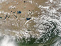
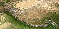
NASA satellite image of the south-eastern area of Tibetan Plateau. Bramaputra River is in the lower right.
-
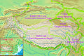
The Tibet Autonomous Region, Qinghai Province and Sichuan Province of the People's Republic of China lie on the Tibetan Plateau.
-
The Tibetan Plateau lies between the Himalayan range to the south and the Taklamakan Desert to the north.
Geology and geological history
Animal and plant life
Human history
the Tibetan plateau has a very small "human" history as it is nearly impossible to settle and is one of the most remote and extreme places on earth.
Nomadic culture
Nomads on the Tibetan Plateau and in the Himalayas are the remainders of nomadic practices historically once widespread in Asia and Africa.[7] Their presence was made possible by the adaptation of nomadic people to survive on the world's grassland by raising livestock rather than crops which are unsuitable to the terrain. Archaeological evidence suggests that the colonization leading to the full-time occupation of the plateau occurred much later than the previously thought 30,000 years ago.[citation needed]
Impact on other regions
Role in monsoons
Main article: Monsoon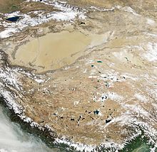 Natural-colour satellite image of the Tibetan Plateau.
Monsoons are caused by the larger amplitude of the seasonal cycle of land temperature compared to that of nearby oceans. This differential warming happens because heat in the ocean is mixed vertically through a "mixed layer" that may be fifty meters deep, through the action of wind and buoyancy-generated turbulence, whereas the land surface conducts heat slowly, with the seasonal signal penetrating perhaps a meter or so. Additionally, the specific heat capacity of liquid water is significantly higher than that of most materials that make up land. Together, these factors mean that the heat capacity of the layer participating in the seasonal cycle is much larger over the oceans than over land, with the consequence that the air over the land warms faster and reaches a higher temperature than the air over the ocean.[8] The hot air over the land tends to rise, creating an area of low pressure. This creates a steady wind blowing toward the land, bringing the moist near-surface air over the oceans with it. Similar rainfall is caused by the moist ocean air being lifted upwards by mountains, surface heating, convergence at the surface, divergence aloft, or from storm-produced outflows at the surface. However the lifting occurs, the air cools due expansion in lower pressure, which in turn produces condensation.
In winter, the land cools off quickly, but the ocean keeps the heat longer. The hot air over the ocean rises, creating a low pressure area and a breeze from land to ocean while a large area of drying high pressure is formed over the land, increased by wintertime cooling.[8] Monsoons are similar to sea and land breezes, a term usually referring to the localized, diurnal (daily) cycle of circulation near coastlines everywhere, but they are much larger in scale, stronger and seasonal.[9] The seasonal monsoon wind shift and weather associated with the heating and cooling of the Tibetan plateau is the strongest such monsoon on Earth.
Effect of climate warming
The Tibetan Plateau contains the world's third-largest store of ice. Qin Dahe, the former head of the China Meteorological Administration, said that the recent fast pace of melting and warmer temperatures will be good for agriculture and tourism in the short term; but issued a strong warning:
"Temperatures are rising four times faster than elsewhere in China, and the Tibetan glaciers are retreating at a higher speed than in any other part of the world." "In the short term, this will cause lakes to expand and bring floods and mudflows." "In the long run, the glaciers are vital lifelines for Asian rivers, including the Indus and the Ganges. Once they vanish, water supplies in those regions will be in peril."[10]
In popular culture
Zhang Qianyi composed a song about the Tibetan plateau, named 青藏高原 (pinyin: Qīngzàng Gāoyuán), which is performed by both Han Hong and subsequently by Russian singer Vitas.
See also
Notes
- ^ Illustrated Atlas of the World (1986) Rand McNally & Company. ISBN 528-83190-9 pp. 164-5
- ^ Atlas of World History (1998) HarperCollins. ISBN 0-72-301025-0 pg. 39
- ^ "The Tibetan Empire in Central Asia (Christopher Beckwith)". http://dannyreviews.com/h/Tibetan_Empire.html. Retrieved 2009-02-19.
- ^ Hopkirk 1983, pg. 1
- ^ "Natural World: Deserts". National Geographic. http://java.nationalgeographic.com/studentatlas/clickup/deserts.html. Retrieved 2007-07-23.
- ^ A Unique Geographical Unit. http://books.google.com/books?id=4q_XoMACOxkC&pg=PA6&dq=%22South+Tibet+Valley%22&output=html&sig=ycLxM4KhdjVGjXem769oQyBwpFE. Retrieved 2007-08-05.
- ^ David Miller. "Nomads of Tibet and Bhutan". asinart.com. http://www.asianart.com/exhibitions/miller/index.html. Retrieved 2008-02-10.
- ^ a b Oracle Thinkquest Education Foundation. monsoons: causes of monsoons. Retrieved on 22 May 2008.
- ^ BBC Weather. The Asian Monsoon. Retrieved on 22 May 2008.
- ^ Global warming benefits to Tibet: Chinese official. Reported 18/Aug/2009.
References
- Hopkirk, Peter (1983). Trespassers on the Roof of the World: The Secret Exploration of Tibet. J. P. Tarcher. ISBN 0874772575.
- Brantingham, P. J. & Xing, G. (2006). "Peopling of the northern Tibetan Plateau". World Archaeology 38 (3): 387–414.
External links
- ON THINNER ICE 如履薄冰 (by GRIP, Asia Society and MediaStorm)
- The End of Earth's Summer
- Long Rivers and Distant Sources
- "Roof of the Earth" Offers Clues About How Our Planet Was Shaped
- Plateau Perspectives (international NGO)
- Leaf morphology and the timing of the rise of the Tibetan Plateau
- Todays weather in the eastern Chang Tang
- Protected areas of the Tibetan Plateau region
- North Tibetan Plateau-Kunlun Mountains alpine desert
- Photos of Tibetan nomads
- "Roof of the Earth" Offers Clues About How Our Planet Was Shaped
Subfields of physical geography 
Plateaus of China Bashang Plateau • Hetao • Loess Plateau • Mongolian Plateau • Ngong Ping • Tibetan Plateau • Wuzhang Plains • Yunnan-Guizhou Plateau •Gansu topics General Geography Cities • Tibetan Plateau • Loess Plateau • Yellow River • Gobi Desert • Qilian Mountains • Hexi Corridor • Qilian Mountains • Liujiaxia DamEducation Culture Tangwang languageCuisine Visitor attractions Jiayuguan Pass • Bingling Temple • Mogao Grottoes • Silk Route Museum • Labrang Monastery • Maijishan GrottoesYunnan topics General Geography Cities • Yunnan-Guizhou Plateau • Diqing Plateau • Honghe River • Dianchi Lake • Fuxian Lake • Erhai Lake • Lugu Lake • Yangzong Lake • Yilong Lake • Xi River • Yuan River • Pearl River • Red River • Pudacuo National ParkEducation Culture Music • Eighteen OdditiesCuisine Visitor attractions Categories:- Plateaus of China
- Plateaus of India
- Geography of Tibet
- Montane ecology
- Physiographic provinces
-


Wikimedia Foundation. 2010.