- Meadowbrook (SEPTA station)
-
Meadowbrook
SEPTA regional rail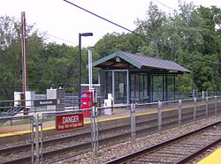
Meadowbrook StationStation statistics Address Mill Road & Lindsay Avenue
Abington, PACoordinates 40°06′41″N 75°05′33″W / 40.1114°N 75.0925°WCoordinates: 40°06′41″N 75°05′33″W / 40.1114°N 75.0925°W Lines West Trenton LinePlatforms 2 side platforms Tracks 2 Parking 90 Other information Owned by SEPTA Fare zone 3 Services Preceding station SEPTA Following station toward University CityWest Trenton Line toward West TrentonMeadowbrook is a station along the SEPTA West Trenton Line (SEPTA) to Ewing, New Jersey. It is located at Mill Road & Lindsay Lane in Abington, Pennsylvania. The station has off-street parking. The station building was destroyed by a fire in April 1995 and was replaced by the bus shelter type of facility that currently serves as the waiting area.
External links
Communities Abington · Ardsley · Crestmont · Elkins Park · Glenside · Hollywood · Huntingdon Valley · McKinley · Meadowbrook · Noble · North Hills · Roslyn · Roychester · Rydal · Willow GroveMajor Roads Railroad Stations Education Attractions History Parks Website: Abington.org Categories:- SEPTA Regional Rail stations
- Stations along Reading Company lines
- Pennsylvania railway station stubs
- SEPTA stubs

Wikimedia Foundation. 2010.