- Medvezhyegorsk
-
For other uses, see Karhumäki brothers.
Medvezhyegorsk (English)
Медвежьегорск (Russian)- Town[citation needed] - 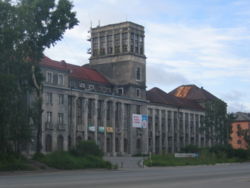
Medvezhyegorsk canal building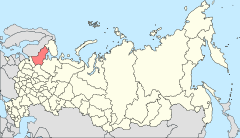
Location of the Republic of Karelia in Russia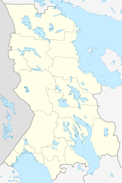
 Medvezhyegorsk
Coordinates: 62°55′N 34°28′E / 62.917°N 34.467°ECoordinates: 62°55′N 34°28′E / 62.917°N 34.467°E Administrative status Country Russia Federal subject Republic of Karelia Statistics Population (2010 Census,
preliminary)15,536 inhabitants[1] Population (2002 Census) 17,283 inhabitants[2] Time zone MSD (UTC+04:00)[3] Founded 1600s[citation needed] Dialing code(s) +7 86 224 501[citation needed] Official website Medvezhyegorsk (Russian: Медвежьего́рск; Karelian: Karhumägi; Finnish: Karhumäki), formerly known as Medvezhya Gora and Karhumäki, is a town and the administrative center of Medvezhyegorsky District of the Republic of Karelia, Russia. Population: 15,536 (2010 Census preliminary results);[1] 17,283 (2002 Census);[2] 20,373; (1989 Census)[4] 15,800 (1959).
There was a village there since the 17th century, but it did not achieve town status until 1916, when it was known as Medvezhya Gora (literally, "bear mount"). The current name was given to it in 1938. Between 1703–1710 and 1766–1769, a factory was operating on the site of the city. The town was occupied by Finland during World War II between 1941 and 1944.[5]
Medvezhyegorsk is on the Murmansk railway south of the White Sea, and at the north end of Lake Onega. The White Sea-Baltic Canal passes by it. Elevation: 262 feet (80 m).
References
- ^ a b Федеральная служба государственной статистики (Federal State Statistics Service) (2011). "Предварительные итоги Всероссийской переписи населения 2010 года (Preliminary results of the 2010 All-Russian Population Census)" (in Russian). Всероссийская перепись населения 2010 года (All-Russia Population Census of 2010). Federal State Statistics Service. http://www.perepis-2010.ru/results_of_the_census/results-inform.php. Retrieved 2011-04-25.
- ^ a b Федеральная служба государственной статистики (Federal State Statistics Service) (2004-05-21). "Численность населения России, субъектов Российской Федерации в составе федеральных округов, районов, городских поселений, сельских населённых пунктов – районных центров и сельских населённых пунктов с населением 3 тысячи и более человек (Population of Russia, its federal districts, federal subjects, districts, urban localities, rural localities—administrative centers, and rural localities with population of over 3,000)" (in Russian). Всероссийская перепись населения 2002 года (All-Russia Population Census of 2002). Federal State Statistics Service. http://www.perepis2002.ru/ct/doc/1_TOM_01_04.xls. Retrieved 2010-03-23.
- ^ Правительство Российской Федерации. Постановление №725 от 31 августа 2011 г. «О составе территорий, образующих каждую часовую зону, и порядке исчисления времени в часовых зонах, а также о признании утратившими силу отдельных Постановлений Правительства Российской Федерации». Вступил в силу по истечении 7 дней после дня официального опубликования. Опубликован: "Российская Газета", №197, 6 сентября 2011 г. (Government of the Russian Federation. Resolution #725 of August 31, 2011 On the Composition of the Territories Included into Each Time Zone and on the Procedures of Timekeeping in the Time Zones, as Well as on Abrogation of Several Resolutions of the Government of the Russian Federation. Effective as of after 7 days following the day of the official publication).
- ^ "Всесоюзная перепись населения 1989 г. Численность наличного населения союзных и автономных республик, автономных областей и округов, краёв, областей, районов, городских поселений и сёл-райцентров. (All Union Population Census of 1989. Present population of union and autonomous republics, autonomous oblasts and okrugs, krais, oblasts, districts, urban settlements, and villages serving as district administrative centers.)" (in Russian). Всесоюзная перепись населения 1989 года (All-Union Population Census of 1989). Demoscope Weekly (website of the Institute of Demographics of the State University—Higher School of Economics. 1989. http://demoscope.ru/weekly/ssp/rus89_reg.php. Retrieved 2010-03-23.
- ^ History of Medvezhyegorsk (in Russian)
External links
- Official website of Medvezhyegorsk
- "Behind Kirov's Back (Medvezhyegorsk sketches)", by Svetlana Rapenkova, Соловецкое море. no 6. 2007 (Russian)
Administrative divisions of the Republic of Karelia Capital: PetrozavodskCities and towns Belomorsk · Kem · Kondopoga · Kostomuksha · Lakhdenpokhya · Medvezhyegorsk · Olonets · Pitkyaranta · Pudozh · Segezha · Sortavala · Suoyarvi
Urban-type settlements Chupa · Kalevala · Khelyulya · Loukhi · Muyezersky · Nadvoitsy · Pryazha · Pyaozersky · Pindushi · Povenets · VyartsilyaAdministrative districts (raions) Belomorsky · Kalevalsky · Kemsky · Kondopozhsky · Lakhdenpokhsky · Loukhsky · Medvezhyegorsky · Muyezersky · Olonetsky · Pitkyarantsky · Prionezhsky · Pryazhinsky · Pudozhsky · Segezhsky · SuoyarvskyCategories:- Cities and towns in the Republic of Karelia


Wikimedia Foundation. 2010.