- New Jersey Route 167
-
Route 167
Route information Maintained by New Jersey Department of Transportation Length: 2.76 mi[1] (4.44 km)
(0.77 miles (1.24 km) of actual roadway)Existed: 1953 – present Southern section Length: 0.62 mi[1] (1.00 km) South end:  US 9 in Port Republic
North end: Dead end in Port Republic Northern section Length: 0.15 mi[1] (0.24 km) South end: Dead end in Bass River Township North end: US 9 in Bass River TownshipHighway system New Jersey State Highway Routes
Interstate and US←  Route 166
Route 168  →
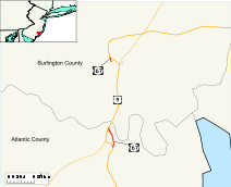
→Route 167 is a short, 0.77-mile (1.24 km) long unsigned state highway in Atlantic and Burlington Counties in New Jersey. The route is one of the few discontinuous state highways in New Jersey, split by wetlands, the Garden State Parkway and the Mullica River. Although the alignment is registered by the New Jersey Department of Transportation as 2.76 miles (4.44 km) highway, the amount of roadway is considerably shorter. The route begins at an intersection with U.S. Route 9 in Port Republic, where it continues along Old New York Road to an end of roadway at the Parkway embankment. Across the Mullica River, Route 167 continues at a gate for wetlands, heading northward to an intersection with U.S. Route 9 in Bass River Township.
The route originated as part of New Jersey Route 4 during construction of a new state highway in 1917. Route 4 was built northward to the current Route 167 northern terminus in 1926, which was designated as part of U.S. Route 9 that year. The highway was 2.64 miles (4.25 km) long along an iron truss bridge. The route remained intact until construction of the Garden State Parkway and a new bridge over the Mullica River in 1948. When the bridge was finished, Route 9 was realigned off the roadway and the prior alignment became Route 167 during the New Jersey state highway renumbering. The route was split twice since 1953, first by the removal of the old Mullica River bridge in 1962 as part of a sale to the National Park Service for a refuge in Virginia, then the northern portion was dismantled except for a 0.12 miles (0.19 km) long alignment for a wetland mitigation project. Today, the route remains in half and the road is still maintained by the state.
Contents
Route description
 Route 167 southbound near the few signage designating the highway, a 0.1 milepost marker in Port Republic
Route 167's southern terminus is located at an intersection with U.S. Route 9 (New York Road) in the city of Port Republic. The route then intersects with the original alignment of New York Road, now known today as Old New York Road. Route 167 crosses over a stream, intersecting with a privately-maintained roadway soon after. The route approaches the Garden State Parkway, but ends at a gate just nearby.[1] The purpose of the gate is to block off the roadway, which previously crossed underneath.
After a 1.99-mile (3.20 km) gap in the roadway, which consists of a former bridge over the Mullica River dismantled and moved to Virginia and bridges removed for wetlands mitigation in the marshes just north, and the orphaned roads in between, which are visible from the Garden State Parkway to the west, Route 167 resurfaces in Bass River Township as a short dead-end street only approximately 800 ft (0.24 km) long, serving only a few homes. The route intersects with Bogan Lane and comes to an end at an intersection with U.S. Route 9.[1] The route's official speed limit, which is not signed, is 25 mph (30 km/h) at its southern segment and 50 mph (70 km/h) in its northern segment.[2] However the Straight Line Diagrams produced by the Department of Transportation list both segments as 50 mph (70 km/h).[1]
History
Route 167 originates as a part of New Jersey Route 4 from Absecon to Rahway, designated in the 1920s.[3] The route remained intact for several years, receiving the co-designation of U.S. Route 9 in 1926, when the nationwide system was assigned.[4] In 1927, the New Jersey State Highway Department had a state-wide state highway renumbering, extending Route 4 in both directions.[5] The two routes remained intact until the construction of the Garden State Parkway's tenth section from New Jersey Route 43 in Absecon to Dover Road in 1948. That year, a bridge over the Mullica River for the Parkway, in which Routes 4 and 9 were realigned onto, was constructed, replacing the alignment over the old structure. During construction, Route 4 and Route 9 was realigned onto a temporary alignment to the older structure, wnile the old one remained unnumbered.[6] The bridge was finished in 1954, and Route 9 was realigned onto the new bridge.[7] (Route 4 was truncated back to Bergen County during the 1953 state highway renumbering[8].)
 Route 167 approaching the embankment of the Garden State Parkway in Port Republic
Upon the realignment of U.S. Route 9, the State Highway Department renumbered the former alignment as Route 167.[8] The route, originally 55 feet (17 m) wide, was shortened during the construction of the new alignments, which also involved taking homes and properties from the highway. The former portion became a gravel road upon completion in Port Republic.[9] Route 167 now continued along the former alignment, using the iron truss bridge built in 1917 for Route 4 to the intersection with U.S. Route 9 in Bass River Township.[10] The old iron truss bridge lasted several years after the realignment, lasting past 1960.[11] The truss bridge was dismantled in 1962, and sold to the state of Virginia and the National Park Service for the National Wildlife Refuge.[12] The route remained intact for a couple decades, with a gap in the highway. The State Highway Department registered the alignment of Route 167 in 1969 as 2.64 miles (4.25 km) long, although there was a gap in the roadway.[13]
The route's northern half from the Mullica River, constructed in 1926 as part of Route 4,[14] was dismantled in 1984 for Edwin B. Forsythe National Wildlife Refuge.[15] As of 2007, Route 167 is unsigned, running from U.S. Route 9 in Port Republic to the bank of the Garden State Parkway at the Mullica River Bridge on its south side and from U.S. Route 9 to a gate on the north side.[16] The straight line diagrams also mention the length of the roadway being 2.76 miles (4.44 km) long, although only 0.77-mile (1.24 km) is still roadway.[1]
Major intersections
County Location Mile[1] Destinations Notes Atlantic Port Republic 0.00 US 90.62 Roadway ends at Garden State Parkway embankment Burlington Bass River Township 2.61 Gate at wetlands 2.76 US 91.000 mi = 1.609 km; 1.000 km = 0.621 mi See also
 U.S. Roads portal
 New Jersey portal
References
- ^ a b c d e f g h New Jersey Department of Transportation. "Route 167 straight line diagram". New Jersey State Department of Transportation. http://www.state.nj.us/transportation/refdata/sldiag/00000167__-.pdf. Retrieved 2007-03-26.
- ^ New Jersey State Department of Transportation (2008). "Speed Limits for State Roads: Route 167". New Jersey State Department of Transportation. http://www.state.nj.us/transportation/refdata/traffic_orders/speed/rt167.shtm. Retrieved 2008-11-13.
- ^ New Jersey Highway Department (1925). State Highway Route map (Map). http://www.jimmyandsharonwilliams.com/njroads/1920s/route05.htm. Retrieved October 12, 2009.
- ^ Bureau of Public Roads, United States System of Highways, November 11, 1926
- ^ New Jersey Highway Department (1927). Sketch Map Showing Approximate Locations of State Highway Routes (Map). http://www.jimmyandsharonwilliams.com/njroads/1920s/route05.htm. Retrieved June 23, 2009.
- ^ Garden State Parkway Section 10 Highway Map. New Jersey Highway Authority. 1948.
- ^ Inventory, National Bridge (2008). Structure Number: ++++++++360490T. United States Department of Transportation. pp. 1.
- ^ a b 1953 renumbering, New Jersey Department of Highways, http://en.wikisource.org/wiki/1953_New_Jersey_state_highway_renumbering, retrieved July 31, 2009
- ^ General Parcel Property Map: Route 167 (1953): Section 1 - Port Republic. New Jersey State Highway Department. October 1954.
- ^ Plan and Profile for Route 4: Section 7B. New Jersey State Highway Department. 1917.
- ^ Augustine, William. "The Parkway Bridge spanning the Mullica River between New Gretna and Port Republic, circa 1960. The second iron bridge can be seen under the Parkway Bridge as it had yet to be dismantled.". Rutgers University Library. http://4.bp.blogspot.com/_vkYCO2_xAuM/SdZu0a0W0UI/AAAAAAAABE8/8QPH_jb5GbM/s400/Iron+Bridge+under+PW+Bridge-+c1960.jpg. Retrieved October 12, 2009.
- ^ "Assateague Island NS: An Administrative History". National Park Service. 2003. pp. 1. http://www.nps.gov/archive/asis/adhi/adhi2a.htm. Retrieved October 12, 2009.
- ^ Milepost Log of State Highways (1969 ed.). New Jersey State Highway Department. 1969.
- ^ Plan and Profile: Route 4: Section 7. New Jersey State Highway Department. January 1926.
- ^ "National Park Contact Information: Edwin B Forsythe National Wildlife Refuge". State Parks. 2009. http://www.stateparks.com/edwin_b_forsythe.html. Retrieved October 12, 2009.
- ^ New Jersey Department of Transportation (2007). New Jersey Official Road Map (Map). Cartography by New Jersey Department of Transportation.
External links
Categories:- State highways in New Jersey
- Transportation in Atlantic County, New Jersey
- Transportation in Burlington County, New Jersey


Wikimedia Foundation. 2010.