- North Battleford (Cameron McIntosh) Airport
-
North Battleford (Cameron McIntosh) Airport 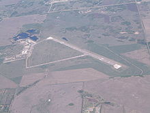
North Battleford Airport IATA: YQW – ICAO: CYQW
– WMO: 71876Summary Airport type Public Operator City of North Battleford Location North Battleford, Saskatchewan Elevation AMSL 1,799 ft / 548 m Coordinates 52°46′09″N 108°14′37″W / 52.76917°N 108.24361°WCoordinates: 52°46′09″N 108°14′37″W / 52.76917°N 108.24361°W Map Location in Saskatchewan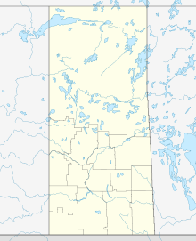
 CYQW
CYQWRunways Direction Length Surface ft m 06/24 2,565 782 Asphalt 12/30 5,000 1,524 Asphalt Statistics (2006) Aircraft movements 9 Source: Canada Flight Supplement[1]
Environment Canada[2]
Movements from Statistics Canada[3]North Battleford (Cameron McIntosh) Airport, (IATA: YQW, ICAO: CYQW), is located 1.5 NM (2.8 km; 1.7 mi) east of North Battleford, Saskatchewan, Canada. The airport is named after Cameron Ross McIntosh, previously the airport was the site of RCAF Station North Battleford. The airport was transferred from Transport Canada to the City of North Battleford on January 1, 1997.[4]
The North Battleford Gliding Centre, a Royal Canadian Air Cadet gliding centre, stores its gliders outside in permanent tie downs, and has office space in a trailer. The gliding centre conducts winch and air-tow operations in both the spring and the fall. The gliding centre currently operates two gliders, Number 2 (C-GCLS) and Number 10 (C-GRFQ); one winch, and one Bellanca Scout Towplane #5 (C-GBAZ).
In April 2010 a contract was awarded for renovations to the air terminal building.[5]
See also
References
- ^ Canada Flight Supplement. Effective 0901Z 20 October 2011 to 0901Z 15 December 2011
- ^ Synoptic/Metstat Station Information
- ^ Total aircraft movements by class of operation
- ^ City transportation infrastructure
- ^ http://www.enterprisesaskatchewan.ca/enr041610
External links
- Page about this airport on COPA's Places to Fly airport directory
- Past three hours METARs, SPECI and current TAFs for North Battleford (Cameron McIntosh) Airport from NAV CANADA as available.
Airports in Canada By name A–B · C–D · E–G · H–K · L–M · N–Q · R–S · T–ZBy location indicator CA · CB · CC · CD · CE · CF · CG · CH · CI · CJ · CK · CL · CM · CN · CO · CP · CR · CS · CT · CV · CW · CY · CZBy province/territory National Airports System Calgary · Charlottetown · Edmonton · Fredericton · Gander · Halifax · Iqaluit · Kelowna · London · Moncton · Montréal-Mirabel · Montréal-Trudeau · Ottawa · Prince George · Québec · Regina · Saint John · St. John's · Saskatoon · Thunder Bay · Toronto · Vancouver · Victoria · Whitehorse · Winnipeg · YellowknifeRelated List of airports by ICAO code: C · List of defunct airports in Canada · List of heliports in Canada · List of international airports in Canada · National Airports System · Operation Yellow RibbonCategories:- Airports in Saskatchewan
- Airports of the British Commonwealth Air Training Plan
- North Battleford
- Saskatchewan airport stubs


Wikimedia Foundation. 2010.