- Darial Gorge
-
 The pass in Luigi Villari's book Fire and Sword in the Caucasus (1906).
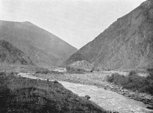
 Looking north along the gorge (8km south of the Russian checkpoint in North Ossetia-Alania).
The Darial Gorge (Russian: Дарьяльское ущелье; Ossetic: Дайраны ком Dairany kom; Georgian: დარიალის ხეობა, Darielis Kheoba) is the gorge on the border between Russia and Georgia. It is at the east base of Mount Kazbek, pierced by the river Terek for a distance of 8 metres between vertical walls of rock (1800 m/5900 ft) and is located South of present-day Vladikavkaz.
Contents
In history
The name Darial originates from Dar-e Alān (در الان) meaning Gate of the Alans in Persian. The gorge, alternatively known as the Iberian Gates or the Caucasian Gates, is mentioned in the Georgian annals under the names of Ralani, Dargani, Darialani; Strabo calls it Porta Caucasica and Porta Cumana; Ptolemy, Fortes Sarmatica; it was sometimes known as Porta Caucasica and Portae Caspiae (a name bestowed also on the "gate" or pass beside the Caspian Sea at Derbent); and the Tatars call it Darioly.
Darial Pass fell into Sassanid hands in 252-253, when the Sassanid Empire conquered and annexed Albania, Iberia, and Armenia. Albania became a vassal of the Sassanid Empire.[1] The control of the Darial Pass switched to the Western Turkic Kaganate in 628, when Tong Yabgu Kagan (Djebukagan of Armenian annals) signed a treaty with Albania, transferring over to the Kaganate the control of all its cities and fortresses, and establishing free trade.[2] Control of Darial Pass switched to the Arab Rashidun Caliphate in 644.[3] From 890 to 929 it belonged to the Sajid Dynasty of Azerbaijan. Afterwards, it was controlled by Tzanaria, Alania, Seljuks, Atabegs of Azerbaijan, Qara Qoyunlu and Aq Qoyunlu, Shirvanshah vassal state of Timur's Empire, Safavids and Qajar state, until it was captured by Russian Empire in the Caucasian War of 1817–1864. Nominally under control of local Khanates, it remained a strategic Russian forepost under Russian control until the dismemberment of the Soviet Union.
Persian king Kavadh I founded several cities in Albania and erected a brick dam between Shirvan and the Gate of the Alans (Dar-e Alān), this is the Darial pass. His son and successor Khosrau I built both the city of Derbent (from Persian دربند meaning closed gate) and the fortress of Darial.[4]
Importance
Darial Pass was historically most important as the one of only two crossing of the Caucasus mountain range, the other being the Derbent Pass, and has been long fortified — at least since 150 BC. Ruins of an ancient fortress are still visible. The pass served as a hub point for many roads connecting North and South Caucasus. and remained open for traffic for most of its existence.
The Russian fort, Darial, which guarded this section of the Georgian Military Road, was built at the northern end of the gorge, at an altitude of 1447 m (4746 ft).
The gorge has been immortalized in Russian poetry, notably by Lermontov in The Demon; it has become known as one of the most romantic places in the Caucasus.
See also
References
- ^ Ehsan Yarshater. The Cambridge history of Iran, Volume 1. Cambridge University Press, 1983. ISBN 0-521-20092-X, 9780521200929, p. 141
- ^ Movses Kagankatvatsi. History of Agvans (Russian trans. and ed. by Patkanov). St. Petersburg, 1861, pp. 121
- ^ Akram A.I. The Muslim Conquest of Persia, Ch:16 ISBN 978-0-19-597713-4
- ^ Alemany, Agustí (2003). "Sixth Century Alania: between Byzantium, Sasanian Iran and the Turkic World". http://docs.google.com/viewer?a=v&q=cache:4RbHUNhLcUoJ:www.transoxiana.org/Eran/Articles/alemany.pdf+darial+built+by+persian&hl=cs&gl=cz&pid=bl&srcid=ADGEESina0frH6VbxqEdSs4yYaGbThmgHGu2zXatmJUF5JSOTaUXFCZw7t9l1yBEHk5dKNJtbk9K6QlzCN_jPQTnxk_ML97byHQMls2E4ktLx_oRCVvPBFoT9mBg86vvnub4kdewyMQm&sig=AHIEtbTd7B0ECFt2RMCz6KiUX8DPyIg7fw. Retrieved 1 April 2011.
 This article incorporates text from a publication now in the public domain: Chisholm, Hugh, ed (1911). Encyclopædia Britannica (11th ed.). Cambridge University Press.
Categories:- Canyons and gorges of Georgia (country)
- Mountain passes of Georgia (country)
- Georgia (country)–Russia border
- Canyons and gorges of Russia
- Mountain passes of Russia

Wikimedia Foundation. 2010.