- Millers Dale
-
 The river Wye at Millers Dale
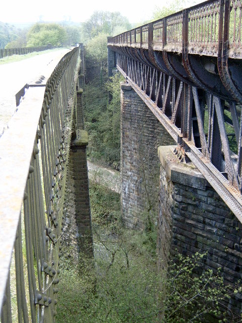
 The twin viaducts at Millers Dale. The left one carries the Monsal Trail.
Millers Dale is a valley on the River Wye in Derbyshire.
It is a popular beauty spot in the Peak District of England, much of the area being preserved as a Site of Special Scientific Interest. Nearby is Ravenstor and Cheedale, both popular with rock-climbers. Just to the north of the Dale lies the village of Wormhill and the lesser known valleys of Peter Dale and Monk's Dale, the latter being listed as a Site of Special Scientific Interest and a nature reserve.
The local landmark is the viaduct, first built by the Midland Railway in 1866. Increasing traffic meant that a second viaduct parallel to the first was built in 1905, increasing the number of tracks to four. Millers Dale railway station was at the junction where passengers for Buxton joined or left the trains between London and Manchester.
The area is of great interest to geologists, particularly where the strata have been exposed by quarries and railway cuttings. In Station Quarry, which is owned by the Naturalists Trust, two layers of limestone can be seen, separated by a bed of shale. At one point there is a dip in the lower layer, possibly from a watercourse, millions of years ago. This is filled with the shale and a large limestone boulder can be seen within it. Elsewhere in the area there are signs of lava flows from long-ago volcanic activity.
Northwards from Millers Dale the line entered the two Chee Tor tunnels (401 and 94 yards), separated by a 50-foot-high (15 m) bridge over the River Wye, then along a ledge cut into the rock face, before entering Rusher Cutting Tunnel (121 yards), crossing the Wye yet again by another viaduct. The line here was immensely difficult and expensive to construct, skirting, as it did, the base of the 300-foot (91 m) high ciff of Chee Tor. Chee number 1 was, until May 2011, sealed off for safety reasons, but it is now possible to walk through all three tunnels. Further on was the triangular junction for Buxton via Blackwell Mill, before continuing to Peak Forest.
Large sections of the trackbed now form part of the Monsal Trail, a cycle and walking trail.
See also
External links
Categories:- Geography of Derbyshire
- Valleys of the Peak District

Wikimedia Foundation. 2010.