Dronfield Woodhouse

Dronfield Woodhouse

Coordinates: 53°18′14″N 1°30′11″W / 53.304°N 1.503°W / 53.304; -1.503

Dronfield Woodhouse
Near Dronfield Woodhouse. - geograph.org.uk - 125313.jpg
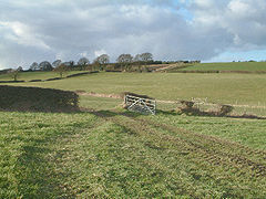
Fields at Dronfield Woodhouse.
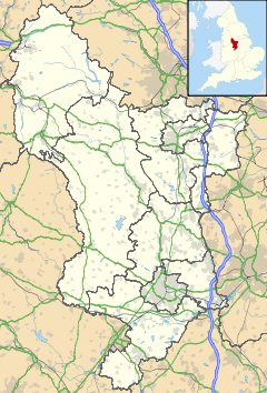
Dronfield Woodhouse is located in Derbyshire
Dronfield Woodhouse

 Dronfield Woodhouse shown within Derbyshire
OS grid reference SK332786
District North East Derbyshire
Shire county Derbyshire
Region East Midlands
Country England
Sovereign state United Kingdom
Post town DRONFIELD
Postcode district S18
Police Derbyshire
Fire Derbyshire
Ambulance East Midlands
EU Parliament East Midlands
List of places: UK • England • Derbyshire

Dronfield Woodhouse is a district of Dronfield, in northeast Derbyshire, England. Its habitation has existed as early as the 11th century (Cowley Farm, to the south) and its main road features a 13th century house and a 19th century Primary School (now an elderly care home).

Although Dronfield Woodhouse today constitutes the western half of the town of Dronfield, until the 1970s (when rapid development took place) practically all of the area consisted of woodland, farmland, and grassland. The 1970s development ("Gosforth Valley") made the district the largest privately owned housing estate in Europe at the time, and is now largely a quiet dormitory settlement for nearby Sheffield and Chesterfield. The surrounding countryside is still readily accessible however, and the boundary of the Peak District National Park is less than 2 miles to the west.

An item of interest for passing tourists is that the Victorian street lamp from the BBC adaptation of The Lion, The Witch and The Wardrobe illuminates the garden of a minor stately home next door to the main public house, 'The Hearty Oak'.

References


Wikimedia Foundation. 2010.

Игры ⚽ Поможем решить контрольную работу

Look at other dictionaries:

  • Dronfield Henry Fanshawe School — Motto Giving Pride through Success Established 1579[1] Type Secondary Headteacher Miss Teresa Roche Chair of Governors Mr. M …   Wikipedia

  • Dronfield — Coordinates: 53°18′09″N 1°27′59″W / 53.3024°N 1.4664°W / 53.3024; 1.4664 …   Wikipedia

  • The Dronfield Henry Fanshawe School — Infobox UK school name = Dronfield Henry Fanshawe School size = 100px latitude = 53.30145 longitude = 1.46638 dms = dms motto = motto pl = established = approx = closed = c approx = type = religion = president = head label = Headteacher head =… …   Wikipedia

  • Over Woodhouse — is a suburban area lying just North West of Bolsover Towncentre, Derbyshire, just to the North of Bolsover Castle, on a hill facing it. The whole area is hemed in by the A632, the B6419 to Shuttlewood, and two other roads which join together and… …   Wikipedia

  • Roy Goodall —  Roy Goodall Spielerinformationen Voller Name Frederick Roy Goodall Geburtstag 31. Dezember 1902 Geburtsort Dronfield, England Sterbedatum 19. Januar …   Deutsch Wikipedia

  • Stagecoach Sheffield — SupertramLink redirects here Infobox Bus transit name = logo size = 250 image size = image caption = company slogan = parent = Stagecoach Group founded = 2006 headquarters = Sheffield, South Yorkshire, England locale = service area = Sheffield… …   Wikipedia

  • Midland Main Line — This article is about the railway line. For the former train operating company, see Midland Mainline. Midland Main Line East Midlands Trains HST at Dore. Overview …   Wikipedia

  • Sheffield — For other uses, see Sheffield (disambiguation). City of Sheffield   City Metropolitan borough   Top left …   Wikipedia

  • List of bus routes in Derbyshire — A map of the area these services operate in. This is a list of bus routes in Derbyshire. The major bus operators in the Derbyshire area are Arriva Midlands and Trent Barton. Other operators in Derbyshire are Bowers, Hulleys of Baslow, Notts Derby …   Wikipedia

  • Contactless smartcards on the railways of Britain — Contactless smart cards are being progressively introduced to replace paper ticketing on the National Rail system of Britain. The first large scale adoption for transit in Britain has been the Transport for London Oystercard. This uses a… …   Wikipedia

Share the article and excerpts

Direct link
Do a right-click on the link above
and select “Copy Link”