- Mappleton
-
Coordinates: 53°52′40″N 0°08′14″W / 53.877820°N 0.137317°W
Mappleton 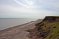
The sands at Mappleton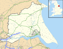
 Mappleton
Mappleton shown within the East Riding of YorkshirePopulation 249 (2001 census)[1] OS grid reference TA225440 Parish Mappleton Unitary authority East Riding of Yorkshire Ceremonial county East Riding of Yorkshire Region Yorkshire and the Humber Country England Sovereign state United Kingdom Post town HORNSEA Postcode district HU18 Dialling code 01964 Police Humberside Fire Humberside Ambulance Yorkshire EU Parliament Yorkshire and the Humber UK Parliament Beverley and Holderness List of places: UK • England • Yorkshire Mappleton is a village and civil parish in the East Riding of Yorkshire, England. It is situated on the North Sea coastline in an area known as Holderness, lying approximately 3 miles (4.8 km) south of the seaside resort of Hornsea. The civil parish is formed by the village of Mappleton and the hamlets of Cowden, Great Cowden and Rolston. According to the 2001 UK census, Mappleton parish had a population of 249.[1]
The parish church of All Saints is a Grade II* listed building.
In 1991, sea defences were built in order to protect the village from intense sea erosion that had threatened it - Holderness is one of the most rapidly eroding areas of the UK. The cliffs had been eroded at a rate of 3.2 yards (2.9 m) per year. The £2 million project created two large rock groynes to halt longshore drift as well as revetments to break the waves. In order to protect the cliffs from undercutting, their gradient was also reduced artificially.
The success of this project has created a larger higher sandy beach for Mappleton, and the erosion has slowed to a point where it is no longer a threat to the settlement. Due to these sea defences, the area directly south of the village now suffers from an even greater rate of erosion.
References
- ^ a b "2001 Census: Key Statistics: Parish Headcounts: Area: Mappleton CP (Parish)". Neighbourhood Statistics. Office for National Statistics. http://neighbourhood.statistics.gov.uk/dissemination/LeadTableView.do?a=3&b=790999&c=Mappleton&d=16&e=15&g=391105&i=1001x1003x1004&m=0&r=1&s=1211193142722&enc=1&dsFamilyId=779. Retrieved 19 May 2008.
- Gazetteer — A–Z of Towns Villages and Hamlets. East Riding of Yorkshire Council. 2006. p. 8.
External links
- Details from listed building database (166695) . Images of England. English Heritage. - All Saints' Church
Coastal settlements of the East Riding of Yorkshire Categories:- Villages in the East Riding of Yorkshire
- Holderness
- Civil parishes in the East Riding of Yorkshire
- Populated coastal places in the East Riding of Yorkshire
- East Riding of Yorkshire geography stubs


Wikimedia Foundation. 2010.