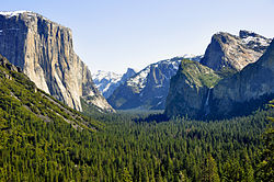
- 1996 Yosemite Valley Landslide
-
The 1996 Yosemite Valley landslide occurred July 10 1996 near the Happy Isles trailhead in Yosemite Valley, Yosemite National Park, Mariposa County, California. 162,000 tons of rocks and other debris fell to the ground at over 160 miles per hour. Of 12 campers/hikers involved in the incident, one was killed. The landslide competes with the January 1997 Merced River flood for the designation of the worst natural disaster in Yosemite to date.
Contents
Details
- Date - July 10, 1996
- Location -
 Yosemite Valley, YNP, Mariposa County, CA,
  USA
USA - Victims - 12
- Fatalities - 1
- Survivors - 11
- Weight of Debris - 162,000 tons
- Speed of Fall - 160+ mph[1]
Impacts
"At 6:52 pm PDT Wednesday, July 10, 1996, a large block of granite, with an estimated volume of 78,000 cubic yards, detached from the cliff between Washburn Point and Glacier Point, in Yosemite Valley." -UC Berkeley Seismograph Station[2]
The first impact occurred at 18:52:28.0 Pacific Daylight Time (02:52:28 UTC), and the second at 18:52:41.6 PDT (02:52:41 UTC).
"After detaching from the cliff, the rock mass slide down a rock shelf for 600 feet at an angle of 50 degrees from vertical and acquired sufficient speed to free-fall ballistically an estimated 1800 feet (550 m) prior to impacting about 200 feet (60 m) from the base of the cliff in the Happy Isles area of the valley floor in Yosemite National Park (field investigation with Gerald Wieczorak and Richard Waitt)." -UC Berkeley Seismograph Station[2]
One of the impacts killed a hiker near the cliffs.See also
- Yosemite National Park
- Happy Isles
- January 1997 Merced River flood
References
Coordinates: 37°43′44″N 119°33′40″W / 37.729°N 119.561°W
Categories:- Yosemite National Park
- 1996 natural disasters
- Natural disasters in California
- History of Mariposa County, California
Wikimedia Foundation. 2010.

