- Micropolis (Besançon)
-
 View of the sector from the hill of Planoise
Micropolis is a sector of the area of Planoise, in the city of Besançon (Doubs, Franche-Comté, France)
History
Before the construction of the halls, the Roy farm was located in this site. This building was a farm, then a chretien church, and was integrate in the new concert building in 1988.[1] A lot of greats events of the city takes place in Micropolis : the "foire comtoise", the big amusement park of the region, Micronora the biggest European microtechnology sallon and the concerts of the city. In 2007, the French president Nicolas Sarkozy choose Micropolis for do his electoral meeting.[2]
See also
- Planoise
- Besançon
References
- ^ Book : author : René Bevalot, title : Planoise… Vous connaissez ?, date : 1995
- ^ « Nicolas Sarkozy in Besançon », B25000, 23 february 2007
Geography Canton of Besançon-Planoise · Châteaufarine · Hauts-de-Chazal · Malcombe · Micropolis · Île-de-France (section) · Époisses (section) · Cassin (section) · Trépillots (attach to Tilleroyes in 1990's)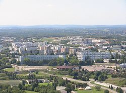
History Buildings Jean Minjoz Hospital · Fort of Planoise · Al-Fath mosque · Francis of Assisi church · Departmental archives of Doubs ·Personality Salah Gaham · Jean-Louis Fousseret · Germinal · Lil Shaolin · Barbara Romagnan ·Medias Categories:- Planoise
- Areas of Besançon


Wikimedia Foundation. 2010.