- Mandalay Region
-
Mandalay Region
မန္တလေးတိုင်းဒေသကြီး— Region — Myanma transcription(s) - Burmese manta.le: tuing: desa. kri: 
FlagLocation of Mandalay Region in Burma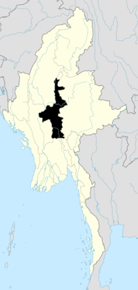
Coordinates: 21°0′N 95°45′E / 21°N 95.75°ECoordinates: 21°0′N 95°45′E / 21°N 95.75°E Country  Burma
BurmaRegion Central Capital Mandalay Government - Chief Minister Ye Myint[1] (USDP) Area[2] - Total 37,021.29 km2 (14,294 sq mi) Population (2005)[2] - Total 7,627,000 - Density 206/km2 (533.6/sq mi) Demographics - Ethnicities Bamar, Chinese, Shan, Chin, Kayin, South Asians - Religions Buddhism, Christianity, Hinduism, Islam Time zone MST (UTC+06:30) Mandalay Region (Burmese: မန္တလေးတိုင်းဒေသကြီး, pronounced [máɴdəlé táiɴ dèθa̰ dʑí], formerly Mandalay Division) is an administrative division of Myanmar. It is located in the center of the country, bordering Sagaing Region and Magway Region to the west, Shan State to the east, and Bago Region and Kayin State to the south. The regional capital is Mandalay. In the south of the division lies the national capital of Naypyidaw. The division consists of seven districts, which are subdivided into 30 townships and 2,320 wards and village-tracts.
Mandalay Region is important in Burma's economy, accounting for 15% of the national economy.
Contents
History
The history of Mandalay Region is the same as that of much of Upper Myanmar except that for much of Burmese history, the political power emanated out of royal capitals located in Mandalay Region. The country's present capital, Naypyidaw, and most former royal capitals of the Burmese nation--Pagan, Ava, Amarapura, Mandalay--are all located here.
The Tibeto-Burman speaking Pyu were the first historical people to dominate the dry zone in central Myanmar that includes Mandalay Region as early as the 1st century AD. By the early 9th century, the Pyu were decimated in a series of wars with the Nanzhao kingdom from Yunnan. The Burmans, who had been migrating into the region from Yunnan in the 9th century, founded a city of their own, Pagan, in 849. The Pagan dynasty gradually came to dominate the central zone over the next two centuries, and by the late 11th century, all of present day Myanmar. The Burmese language and script came to prominence with royal patronage of Pagan kings.
After the fall of Pagan to the Mongols in 1287, parts of central Myanmar came to be controlled by a series of rulers: the Mongols (1287-c.1303), Myinsaing (1298–1312), Pinya (1312–1364), and Sagaing (1315–1364). In 1364, Ava kingdom led by Burmanized Shan kings reunified all of central Myanmar. Central Myanmar was under Ava's control until 1527, and under the Shans of Monhyin (1527–1555). Burmese literature and culture came into its own during this era. Central Myanmar was part of the Taungoo kingdom from 1555 to 1752. Parts of the region fell briefly to the Mons of Pegu (Bago) (1752–1753). Konbaung Dynasty ruled the region until December 1885 when it lost all of Upper Myanmar in the Third Anglo-Burmese War.
The British administration organized seven divisions in Upper Myanmar: Mandalay, Meiktila, Minbu, Sagaing, and the Federated Shan States (North and South). Mandalay Division included what is now Kachin State. Circa 1940, Meiktila Division was merged with Mandalay Division. Much of Upper Myanmar, including Mandalay Division, was under the Japanese rule during World War II between May 1942 and March 1945. When the country gained independence from the United Kingdom in January 1948, the Myikyina and Bhamo districts were carved out to form Kachin State.[3]
Administration
Mandalay Region consists of 31 townships organized into seven districts.
- Kyaukse District
- Mandalay District
- Meiktila District
- Myingyan District
- Nyaung-U District
- Pyinoolwin District
- Yamethin District
Demographics
The majority of the population in Mandalay Region are Bamar (Burmans). In the Mandalay metropolitan area, however, a large community of Chinese, most of whom are recent immigrants from Yunnan, now nearly rival the Bamar population.[4] A large community of Indians also reside in Mandalay. A dwindling community of Anglo-Burmese still exists in both Pyinoolwin and Mandalay. A number of Shan people live along the eastern border of the region.
Burmese is the primary language of the division. However, Mandarin Chinese is increasingly spoken in Mandalay and the northern gem mining town of Mogok.
Economy
Agriculture is the primary economical source of livelihood. Primary crops grown within Mandalay Region are rice, wheat, maise, peanut, sesame, cotton, legumes, tobacco, chilli, and vegetables. Industry, including alcoholic breweries, textile factories, sugar mills, and gem mines also exists. Tourism now forms a substantial part of Mandalay Region's economy, as it contains many historical sites including Mandalay, Amarapura, Bagan, Pyin U Lwin, Mount Popa, and Ava. Hardwoods such as teak and thanaka are also harvested.
Education
See also: List of universities in Mandalay DivisionEducational opportunities in Myanmar are extremely limited outside the main cities of Yangon and Mandalay. According to official statistics, over 1 million students were enrolled in the division's 4467 primary and secondary schools in 2005.[2] Of the total, the vast majority, about 4000, were primary schools. Only about 13% of primary school students make it to high school.[5]
AY 2002-2003 Primary Middle High Schools 4011 231 113 Teachers 19,000 7200 2500 Students 690,000 259,000 91,000 The division has some of the best institutions of higher education in Myanmar. As medical, engineering and computer studies are the most sought after in Myanmar, the University of Medicine, Mandalay, the University of Dental Medicine, Mandalay, Mandalay Technological University, and the University of Computer Studies, Mandalay are among the most selective universities in Myanmar. Other highly selective schools are Myanmar Aerospace Engineering University and military academies in Pyinoolwin: Defence Services Academy and Defence Services Technological Academy.
Health care
See also: List of hospitals in MandalayThe general state of health care in Myanmar is poor. The military government spends between 0.5% to 3% of the country's GDP on health care, consistently ranking among the lowest in the world.[6][7] Although health care is nominally free, in reality patients have to pay for medicine and treatment even in public clinics and hospitals. Public hospitals lack many of the basic facilities and equipment. The following is a summary of the public health system in the division, in the fiscal year 2002-2003.[8]
2002–2003 # Hospitals # Beds Specialist hospitals 7 1725 General hospitals with specialist services 5 1650 General hospitals 30 1260 Health clinics 43 688 Total 85 5323 In 2005, Mandalay Region's public health care system had slightly over 1000 doctors and about 2000 nurses working in 44 hospitals and 44 health clinics. Over 30 of the hospitals had less than 100 beds.[2] Since almost all of large public hospitals and private hospitals, and doctors are located in Mandalay, these low numbers for a division with 7.7 million are actually even worse in the rest of the division, though these figures are believed to have improved by the advent of Naypyidaw as the nation's capital in 2006 although the level of improvement remains unreported. The well-to-do bypass the public health system and go to private clinics in Mandalay or Yangon in order to receive quicker medical attention and high-quality service.[9] The wealthy routinely go abroad (usually Bangkok or Singapore) for treatment.[10]
References
- ^ "Division and State Administrations". Alternative Asean Network on Burma. 8 July 2011. http://www.altsean.org/Research/Regime%20Watch/Executive/DivisionsStatesAdmins.php. Retrieved 21 August 2011.
- ^ a b c d Thiha Aung (2005-02-13). "Mandalay Division marching to new golden land of unity and amity". The New Light of Myanmar. http://www.myanmar.gov.mm/Article/Article2005/Feb/Feb13.htm.
- ^ "Myanmar Divisions". Statoids. http://www.statoids.com/umm.html. Retrieved 2009-04-10.
- ^ Stephen Mansfield (1999-05-13). "Myanmar's Chinese connection". The Japan Times. http://search.japantimes.co.jp/cgi-bin/fv19990513a2.html.
- ^ "Education statistics by level and by State and Division". Myanmar Central Statistical Organization. http://www.etrademyanmar.com/STATS/s1701.htm. Retrieved 2009-04-09.
- ^ "PPI: Almost Half of All World Health Spending is in the United States". 2007-01-17. http://www.ppionline.org/ppi_ci.cfm?knlgAreaID=108&subsecID=900003&contentID=254167.
- ^ Yasmin Anwar (2007-06-28). 06.28.2007 "Burma junta faulted for rampant diseases". UC Berkeley News. http://www.berkeley.edu/news/media/releases/2007/06/28_Burma.shtml 06.28.2007.
- ^ "Hospitals and Dispensaries by State and Division". Myanmar Central Statistical Organization. http://www.etrademyanmar.com/STATS/s0413.htm. Retrieved 2009-04-11.
- ^ Aye Lei Tun (2007-06-11). Mandalay continues to play vital role as healthcare centre for the upper north. The Myanmar Times. http://www.mmtimes.com/feature/health/h011.htm.
- ^ Thein Win Nyo (2007-06-11). Medical tourism gives patients options. The Myanmar Times. http://www.mmtimes.com/feature/health/h012.htm.
Gallery
-
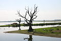
Thaungthaman Lake
-

Sunset from Mandalay Hill
-
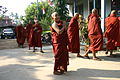
Young Monks at Buddhist Temple

Sagaing Region Magway Region 
Shan State  Mandalay Region

Bago Region Kayin State Note: Naypyidaw Union Territory is completely surrounded by Mandalay Region.Mandalay Region Capital: Mandalay Kyaukse District 

Mandalay District Amarapura Township · Aungmyethazan Township · Chanayethazan Township · Chanmyathazi Township · Mahaaungmye Township · Patheingyi Township · Pyigyidagun TownshipMeiktila District Myingyan District Nyaung-U District Pyinoolwin District Yamethin District Main cities and towns Administrative divisions of Burma (Myanmar) States 
Regions Self-Administered Zones Self-Administered Divisions WaUnion Territories Categories:- Mandalay Region
- Regions of Burma


Wikimedia Foundation. 2010.