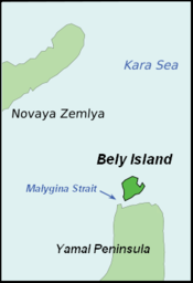
Malygina Strait

Malygina Strait

Coordinates: 72°58′N 69°59′E / 72.96°N 69.98°E / 72.96; 69.98

Bely Island.PNG
Malygina Strait is located in Russia
{{{alt}}}
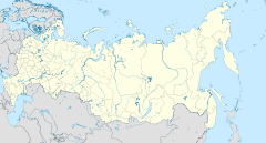
Malygina Strait (Russia)

Malygina Strait or Malygin Strait in Siberia, Russia is an 8 to 10 km wide sound which is frozen most of the year. It separates Bely Island from the Yamal Peninsula in the Yamalo-Nenets Autonomous Okrug, Tyumen Oblast. The strait is named after explorer Stepan Malygin, who was the first to make an instrumental mapping of its coasts during the Great Northern Expedition in the 18th century.


Wikimedia Foundation. 2010.

Игры ⚽ Поможем сделать НИР

Look at other dictionaries:

  • Bely Island — Infobox Islands name = Bely image caption = Bely Island, Kara Sea image size = locator Location map|Russia|lat=73.25|long=70.833333 map custom = yes native name = Остров Белый native name link = Russian language nickname = location = Kara Sea… …   Wikipedia

  • Yamal Peninsula — Peninsula between the Kara Sea and the Gulf of Ob, northwestern Siberia, west central Russia. It has a total length of 435 mi (700 km), a maximum width of 150 m (240 km), and an area of 47,100 sq mi (122,000 sq km). There are large natural gas… …   Universalium

  • 71-й меридиан восточной долготы — У этого термина существуют и другие значения, см. 71 й меридиан …   Википедия

Share the article and excerpts

Direct link
Do a right-click on the link above
and select “Copy Link”