- Magdalen Laver
-
Coordinates: 51°45′11″N 0°11′10″E / 51.753°N 0.186°E
Magdalen Laver 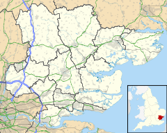
 Magdalen Laver
Magdalen Laver shown within EssexDistrict Epping Forest Shire county Essex Region East Country England Sovereign state United Kingdom EU Parliament East of England List of places: UK • England • Essex Magdalen Laver is a village and a civil parish in the Epping Forest district, in the county of Essex, England. Magdalen Laver has a village hall[1] and a church called St Mary Magdalen.[2]
References
External links
- Listed buildings in Magdalen Laver
- http://www.british-history.ac.uk/report.aspx?compid=15586
- http://www.british-history.ac.uk/report.aspx?compid=15588
The District of Epping Forest Parishes Abbess Beauchamp and Berners Roding • Bobbingworth • Buckhurst Hill • Chigwell • Epping • Epping Upland • Epping Green • Fyfield • High Laver and Little Laver • High Ongar • Lambourne • Loughton • Magdalen Laver • Matching • Matching Green • Matching Tye • Moreton • Nazeing • North Weald Bassett • Chipping Ongar • High Ongar • Roydon • Sheering • Stanford Rivers • Stapleford Abbotts • Stapleford Tawney • Theydon Bois • Theydon Garnon • Theydon Mount • Waltham Abbey • WillingaleAttractions Constituencies Categories:- Villages in Essex
- Epping Forest
- Civil parishes in Essex
- Essex geography stubs

Wikimedia Foundation. 2010.