- Evrostina
-
Evrostina
ΕυρωστίναLocation 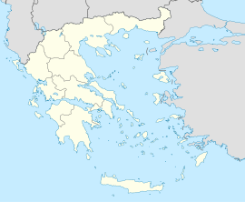
 Evrostina
Coordinates 38°8′N 22°25′E / 38.133°N 22.417°ECoordinates: 38°8′N 22°25′E / 38.133°N 22.417°E Location within the peripheral unit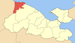
Government Country: Greece Region: Peloponnese Regional unit: Corinthia Municipality: Xylokastro-Evrostina Population statistics (as of 2001) Municipal unit - Population: 5,882 Other Time zone: EET/EEST (UTC+2/3) Elevation (center): 5 m (16 ft) Postal: 200 09 Telephone: 27430 Auto: ΚΡ Website evrostini.gr Evrostina (Greek: Ευρωστίνα) is a town and a former municipality in Corinthia, Peloponnese, Greece. Since the 2011 local government reform it is part of the municipality Xylokastro-Evrostina, of which it is a municipal unit.[1] Its seat of administration is the town Derveni. The old Greek National Road 8 and the new Greek National Road 8A (Corinth - Patras) pass through the north of the municipal unit. Patras is about 73 km E, NW of Stymfalia, 4 km N of Rozena, about 50 km W of Corinth and about 142 km W of Athens. It borders on Achaea to the west.
Contents
Subdivisions
The municipal unit Evrostina is subdivided into the following communities (constituent villages in brackets):
- Derveni (Derveni, Mavra Litharia, Petalou)
- Elliniko
- Evrostina (Evrostina, Ano Aigialos, Koumarias, Rozena)
- Kallithea (Kallithea, Skoupaiika)
- Lygia
- Lykoporia
- Pyrgos
- Sarantapicho (Sarantapicho, Sarantapichiotika)
- Stomio
- Chelydoreo (Chelydoreo, Mentourgianika)
Historical population
Year Municipal district Municipality 1981 1,347 - 1991 1,060 5,688 2001 1,084 5,882 The village has a school, a lyceum, a gymnasium, a church, post office, banks, a train station, a beach and a square (plateia). The town is lined up within the highway and the shoreline.
A grassy green mountain is about 100 south of the centre while another mountain is in the southwest. Olive groves are founded in the west. Farmlands are founded east of Derveni. Some forests are lined up with the superhighway.
External links
- http://www.evrostini.gr (in Greek)
See also
- Evrostina (mountain), a mountain elevation at 400 m. It also has a weather tower.
- List of settlements in the Corinthia prefecture
North: Gulf of Corinth West: Aigeira Evrostina East: Xylokastro South: Feneos References
- ^ Kallikratis law Greece Ministry of Interior (Greek)
Municipal unit of Evrostina Municipal unit of Xylokastro Ano Trikala · Dendro · Geliniatika · Kamari · Karya · Kato Loutro · Kato Synoikia Trikalon · Korfiotissa · Lagkadaiika · Mesi Synoikia Trikalon · Manna · Melissi · Nees Vrysoules · Panariti · Pellini · Pitsa · Rethi · Riza · Sofiana · Stylia · Sykia · Thalero · Throfari · Xanthochori · Xylokastro · ZemenoCategories:- Populated places in Corinthia


Wikimedia Foundation. 2010.