- Deeping St Nicholas
-
Coordinates: 52°43′42″N 0°12′07″W / 52.7284°N 0.20205°W
Deeping Saint Nicholas 
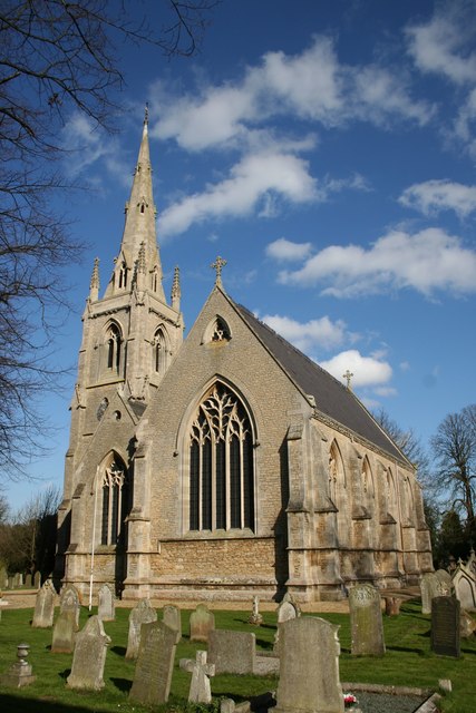
Deeping St Nicholas church
 Deeping Saint Nicholas
Deeping Saint Nicholas shown within LincolnshirePopulation 1,323 [1] OS grid reference TF215160 Parish Deeping St Nicholas District South Holland Shire county Lincolnshire Region East Midlands Country England Sovereign state United Kingdom Post town SPALDING Postcode district PE11 3 Dialling code 01775 63 Police Lincolnshire Fire Lincolnshire Ambulance East Midlands EU Parliament East Midlands UK Parliament South Holland and The Deepings List of places: UK • England • Lincolnshire Deeping St Nicholas, near Spalding in Lincolnshire, England is a village on the A16 road between The Deepings and Spalding. Unlike Market Deeping, which is in South Kesteven, Deeping St Nicholas is in South Holland.
Deeping St Nicholas is also a Civil Parish[2][3] in South Holland, including the small settlements of Tongue End and Hop Pole, and a surprising number of outlying farms. It has a total population of 1,323.
Contents
The Village
The village has a beautiful 19th century stone church, the parish church of St Nicholas. The eclesiastical parish is part of the Elloe West Deanery of the Diocese of Lincoln, and part of a group with St John's, Spalding. The shared incumbent is The Revd. peter Garland.[4] The Chapel built in 1867, is still open under the minister, Rev. Ann Bossingham. It is part of the South Lincolnshire Circuit of the Methodist Church
At 7 miles long, the village has the distinction of being the longest in the United Kingdom[citation needed].
The whole civil parish falls within the drainage area of the Welland and Deepings Internal Drainage Board.[5]
At the Western end of the village is a level crossing for the Lincoln - Peterborough railway line, the site of the former Littleworth railway station. The goods shed there was used for agricultural produce, including transshipment from the narrow gauge potato railway that also crossed the road.
A Primary School opened on 2 January 1877 with a roll of 5 under a Mr Hanley. The current head teacher, Anita Bandey, oversees over 50 children.[6]
Recently, eight large wind turbines, the blades of which are 42 metres in length, have been constructed on land to the north of the settlement, causing much protest within the local community.[citation needed] Proponents of the turbines, however, highlight the environmentally friendly nature of the energy that is generated by the turbines, citing strong winds and relatively small local populations as a reason for their construction.
History
In the 1086 Domesday book, the village is named as Estdeping.[7]
From John Marius Wilson's Imperial Gazetteer of England and Wales of 1872:
-
- DEEPING FEN, a fen and a chapelry in Bourn district, Lincoln. The fen lies on the North Drove and the South Drove drains, between Market-Deeping and Spalding; and comprises upwards of 30, 000 acres. About one-half consists of enclosed commons, included in parishes; and the rest is extra-parochial. The chapelry comprises the extra-parochial part; was constituted in 1846; bears the alternative name of Deeping-St. Nicholas; lies adjacent to North Drove railway station, and 5 miles WSW of Spalding; and has a post office, of the name of Deeping-St. Nicholas, under Spalding. Acres, 16, 290. Real property, £27, 681. Pop., 1, 180. Houses, 184. The living is a vicarage in the diocese of Lincoln. Value, £210. Patrons, the Trustees of the late W. Stevenson, Esq. The church was built in 1846.
- DEEPING FEN, a fen and a chapelry in Bourn district, Lincoln. The fen lies on the North Drove and the South Drove drains, between Market-Deeping and Spalding; and comprises upwards of 30, 000 acres. About one-half consists of enclosed commons, included in parishes; and the rest is extra-parochial. The chapelry comprises the extra-parochial part; was constituted in 1846; bears the alternative name of Deeping-St. Nicholas; lies adjacent to North Drove railway station, and 5 miles WSW of Spalding; and has a post office, of the name of Deeping-St. Nicholas, under Spalding. Acres, 16, 290. Real property, £27, 681. Pop., 1, 180. Houses, 184. The living is a vicarage in the diocese of Lincoln. Value, £210. Patrons, the Trustees of the late W. Stevenson, Esq. The church was built in 1846.
The Church of St Nicholas was built in 1846, when a new parish was formed to supersede the former chapel-of-ease of Spalding. The church was built by Charles Kirk, an architect from Sleaford, in the Decorated style so common in older surrounding churches.[8] The Parish is, in modern times, again managed from St Johns, Spalding restoring the medieval situation. The village name Deeping St Nicholas appears to date from this same time, explaining why the railway station is called Littleworth.
Businesses
The majority of employment remains agriculture, but there are some other businesses:
- The Plough Inn
- Vine House farm shop
- Marjoram Motors MOT Centre (garage)
- R T Randal Ltd (garage)
- J A Watts (Mareham) Ltd (farming)
- J Woodhead (farming)
References
- ^ "Office for National Statistics web page - Population for whole civil parish". http://www.neighbourhood.statistics.gov.uk/dissemination/LeadTableView.do?a=7&b=796381&c=PE11+3EN&d=16&e=15&g=468277&i=1001x1003x1004&m=0&r=0&s=1250542594079&enc=1&dsFamilyId=779.
- ^ "Civil Parish details". http://community.lincolnshire.gov.uk/deepingstnicholas/section.asp?catId=20700.
- ^ "Parish council noticeboard". http://www.photoimagery.co.uk/council/.
- ^ "Eclesiastical parish details". http://www.stjohnsspalding.org/.
- ^ "Welland and Deepings IDB". http://www.wellandidb.org.uk/.
- ^ "Primary School web site". http://www.dsnschool.org.uk/.
- ^ Mills, A. D. (1991). A Dictionary of English Place-Names. Oxford University Press.
- ^ "Church History". http://www.stjohnsspalding.org/history.htm.
External links
Settlements within The Deepings See also: Stowgate · Frognall · Tongue End · Hop Pole Categories:- Villages in Lincolnshire
- The Deepings
- Civil parishes in Lincolnshire
- Wind farms in England
-

Wikimedia Foundation. 2010.