- Chemin-A-Haut State Park
-
Chemin-A-Haut State Park 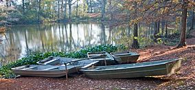
Boats on the water in Chemin-A-Haut State Park.Map of Louisiana, United States of America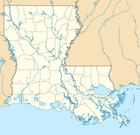

Location Morehouse Parish, Louisiana, United States of America Coordinates 32°54′36″N 91°50′42″W / 32.91°N 91.845°WCoordinates: 32°54′36″N 91°50′42″W / 32.91°N 91.845°W[1] Area 503 acres (2.04 km2; 0.786 sq mi)[1] Established 1935[2] Governing body Louisiana Office of State Parks Official website Chemin-A-Haut State Park is a 503-acre (2.04 km2) site located in northern Morehouse Parish, Louisiana. Visitors may access the park from U.S. Highway 425 about 10 miles (16 km) north of Bastrop. Chemin-à-Haut means "High Road" in French. Much of the park is on a high bluff overlooking winding Bayou Bartholomew. Chemin-A-Haut was one of the earliest additions to the Louisiana State Park system.
The Nature Conservancy in Louisiana has recently acquired the 247-acre (1.00 km2) DeBlieux tract, located in a large bend of Bayou Bartholomew, and will eventually transfer the land to the State of Louisiana. The property will be added to Chemin-A-Haut, thus increasing the park's size to 750 acres (3.0 km2).[3] Bayou Bartholomew contains over 115 fish species, one of the highest counts of any stream in North America.
Visitors to Chemin-A-Haut State Park may enjoy Camping, Fishing, Hiking, Picnicking and Wildlife Observation. There is a 8-mile (13 km) Equestrian Trail for Horseback riders. During the hot Summer months, guests may cool off in an on-site swimming pool.
References
- ^ a b "Chemin-A-Haut State Park - Louisiana Office of State Parks". http://www.crt.state.la.us/parks/icheminah.aspx. Retrieved 30 January 2011.
- ^ 2009 Wall Calendar - 75 Years of Celebrating Louisiana's Treasures and Making Memories. Louisiana State Parks. 2009.
- ^ "The Nature Conservancy in Louisiana - TNC Acquires Property Adjacent to Bayou Bartholomew to Expand Chemin-A-Haut State Park". http://www.nature.org/wherewework/northamerica/states/louisiana/press/press4074.html.
External links
Protected Areas of Louisiana Federal National Marine Sanctuary:Atchafalaya · Bayou Cocodrie · Bayou Sauvage · Bayou Teche · Big Branch Marsh · Black Bayou Lake · Bogue Chitto · Breton · Cameron Prairie · Cat Island · Catahoula · D'Arbonne · Delta · East Cove · Grand Cote · Handy Brake · Lacassine · Lake Ophelia · Mandalay · Red River · Shell Keys · Sabine · Tensas River · Upper Ouachita
State Bayou Segnette · Bogue Chitto · Chemin-A-Haut · Chicot · Cypremort Point · Fairview-Riverside · Fontainebleau · Grand Isle · Hodges Gardens · Jimmie Davis · Lake Bistineau · Lake Bruin · Lake Claiborne · Lake D-Arbonne · Lake Fausse Pointe · North Toledo Bend · Palmetto Island · Poverty Point Reservoir · St. Bernard · Sam Houston Jones · South Toledo Bend · Tickfaw
State Historic SitesAudubon · Centenary · Fort Jesup · Fort Pike · Fort St. Jean Baptiste · Forts Randolph & Buhlow · Locust Grove · Longfellow-Evangeline · Los Adaes · Mansfield · Marksville · Plaquemine Lock · Port Hudson · Poverty Point · Rebel State · Rosedown Plantation · Winter Quarters
State Preservation AreaState ForestsState Wildlife RefugesElmer's Island · Marsh Island · Rockefeller · St. Tammany · State · Terrebonne Barrier Islands · White Lake WetlandsWildlife management areasAcadiana Conservation Corridor · Atchafalaya Delta · Attakapas · Barataria Preserve · Bayou Macon · Bayou Pierre · Ben's Creek · Big Colewa Bayou · Big Lake · Biloxi · Bodcau · Boeuf · Bonnet Carre Spillway · Buckhorn · Camp Beauregard · Catahoula Lake · Clear Creek · Dewey Wills · Elbow Slough · Elm Hall · Floy Ward McElroy · Fort Polk · Grassy Lake · Hutchinson Creek · Indian Bayou · Jackson Bienville · Joyce · Lake Boeuf · Lake Ramsey Savannah · Little River · Loggy Bayou · Manchac · Marsh Bayou · Maurepas Swamp · Old River Control · Ouachita · Pass A Loutre · Pearl River · Peason Ridge · Pointe-aux-Chenes · Pomme de Terre · Red River · Russell Sage · Sabine Island · Sabine · Salvador/Timken · Sandy Hollow · Sherburne · Sicily Island Hills · Soda Lake · Spring Bayou · Tangipahoa Parish School Board · Thistlethwaite · Three Rivers · Tunica Hills · Union · Walnut Hill · West BayOther PrivateCategories:- Louisiana state parks
- Protected areas of Morehouse Parish, Louisiana
- Louisiana geography stubs
- Southern United States protected area stubs


Wikimedia Foundation. 2010.