- Aqir
-
Aqir 
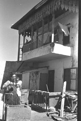
Palestinian house in Aqir, post 1948
 Aqir
AqirArabic District Ramla Coordinates 31°51′39.63″N 34°49′23.11″E / 31.8610083°N 34.8230861°ECoordinates: 31°51′39.63″N 34°49′23.11″E / 31.8610083°N 34.8230861°E Population 2480[1] (1945) Area 11,322[1] dunums Date of depopulation 6 (??) May 1948[2] Cause(s) of depopulation Military assault by Yishuv forces Current localities Kiryat Ekron,[3] Mazkeret Batya[3] Ganei Yohanan[3] Aqir (also spelled Akir and Akkur) was a Palestinian Arab village in the District of Ramle located 9 km southwest of Ramla and 1 km north of Wadi al-Nasufiyya[4] (today called Nahal Ekron).
Contents
History
Until the early 20th century, Aqir was thought to lie at the site of the ancient Philistine city of Ekron, that has now been identified as Tel Mikne, 9 km to the south.[5] The error seems rooted in antiquity; The Romans referred to the village as Accaron.[4] In the 10th century CE, Al-Muqaddasi writes of Aqir (Ekron) as "A large village with a fine mosque. Its inhabitants are much given to good works. The bread here is not to be surpassed for quality. The village lies on the high road from Ar-Ramlah to Makka."[6][7] Yakut called it Al Akir, and said it belonged to Ar Ramlah.[8]
In 1596, Aqir (Amir) appeared in Ottoman tax registers as being in the Nahiya of Ramla of the Liwa of Gaza. It had a population of 31 Muslim households and paid taxes on wheat, barley, and other produce.[9]
The scholar Edward Robinson passed by the village in 1838, and described it as being surrounded by "well-tilled gardens and fields of the richest soil". The village itself was described as being of "considerable size", built of bricks or adobe.[10] In the 1870s, Aqir was described as "a mud village on low rising ground, with cactus hedges surrounding its gardens, and a well to the north."[11]
At the time of the 1922 census of Palestine, Aqir had a population of 1155 Muslims.[12] This had increased to 1689 Muslims and 2 Christians by the census of 1931.[13]
Between 1941 and 1948, the RAF Aqir air base was located nearby. As of 1945 the village had a population of 2,480 with two elementary schools: one for boys, founded in 1921 which had an enrollment of 391 boys in 1945 and a second for girls, which had an enrollment of 46 girls in 1945. There were two mosques in the village.[3]
In 1944/45, the village had 1,300 dunums of land used for citrus and banana cultivation, while 8,968 dunums were used for cereals, and 914 dunums irrigated or used for orchards.[3][14]
1949, and afterward
The village was depopulated during the 1947–1948 Civil War in Mandatory Palestine on May 6, 1948 during Operation Barak by the Giv'ati Brigade. The remaining village houses was taken over by Kiryat Ekron soon after.[15]
According to the Palestinian historian Walid Khalidi, the village remaining structures on the village land were in 1992:
A number of small houses remain, several of which are occupied by Jewish families. One is a cement house with a gabled roof and rectangular doors and windows, another is similar in its features, but its roof is flat. Cypresses, cycamores and cactuses grow on the site. The surrounding lands are cultivated by Israelis.[3]
References
- ^ a b Hadawi, 1970, p.66
- ^ Morris, 2004, p.xix, village #252. Also gives cause of depopulation.
- ^ a b c d e f Khalidi, 1990, p. 360
- ^ a b Khalidi, 1990, p. 359
- ^ Seymour Gitin and Trude Dothan (1987). "The Rise and Fall of Ekron of the Philistines: Recent Excavations at an Urban Border Site". The Biblical Archaeologist 50 (4): 197–222. doi:10.2307/3210048. JSTOR 3210048.
- ^ Al-Mukaddasi, translated by Le Strange, 1884, p.60
- ^ Al-Mukaddasi, translated by le Strange, 1890, p.389
- ^ Yakut, iii. 697, translated by le Strange, 1890, p.390
- ^ Wolf-Dieter Hütteroth and Kamal Abdulfattah (1977). Historical Geography of Palestine, Transjordan and Southern Syria in the Late 16th Century. Erlanger Geographische Arbeiten, Sonderband 5. Erlangen, Germany: Vorstand der Fränkischen Geographischen Gesellschaft. p. 153. ISBN 9783920405414. http://books.google.com/?id=wqULAAAAIAAJ&q=Historical+Geography+of+Palestine,+Transjordan+and+Southern+Syria+in+the+Late+16th+Century&dq=Historical+Geography+of+Palestine,+Transjordan+and+Southern+Syria+in+the+Late+16th+Century.
- ^ Robinson, 1841, p21- p.25. Cited in Khalidi, 1992, p. 360.
- ^ Conder and Kitchener, 1881, SWP, Vol. II, p.408. Quoted in Khalidi, 1992, p. 521
- ^ J. B. Barron, ed (1923). Palestine: Report and General Abstracts of the Census of 1922. Government of Palestine. Table VII.
- ^ E. Mills, ed (1932). Census of Palestine 1931. Population of Villages, Towns and Administrative Areas. Jerusalem: Government of Palestine. p. 19.
- ^ Hadawi, 1970, p.114
- ^ "אודות קרית עקרון [About Kiryat Ekron]" (in Hebrew). Kiryat Ekron local council. http://kiryat-ekron.muni.il/index.php?id=45. Retrieved 2010-06-29.
Bibliography
- Conder, Claude Reignier and H.H. Kitchener (1881): The Survey of Western Palestine: memoirs of the topography, orography, hydrography, and archaeology. London:Committee of the Palestine Exploration Fund. vol 2
- Hadawi, Sami (1970). Village Statistics of 1945: A Classification of Land and Area ownership in Palestine. Palestine Liberation Organization Research Center. http://www.palestineremembered.com/Articles/General-2/Story3150.html
- Khalidi, Walid (1992). All That Remains: The Palestinian Villages Occupied and Depopulated by Israel in 1948. Washington D.C.: Institute for Palestine Studies. ISBN 0887282245
- Morris, Benny (2004). The Birth of the Palestinian Refugee Problem Revisited. Cambridge University Press. ISBN 9780521009676. http://books.google.com/?id=uM_kFX6edX8C&printsec=frontcover&dq=benny+morris&q.
- Al-Muqaddasi, 1884, Description of Syria, including Palestine translated by Le Strange
- Robinson, Edward, Eli Smith (1841): Biblical Researches in Palestine, Mount Sinai and Arabia Petraea: A Journal of Travels in the Year 1838a, The full text, google-books, Can download PDF. Published by Crocker & Brewster, 1841 Item notes: v. 3
- le Strange, Guy (1890). Palestine Under the Moslems: A Description of Syria and the Holy Land from A.D. 650 to 1500. Committee of the Palestine Exploration Fund. http://www.archive.org/details/palestineundermo00lestuoft
- Sharon, Moshe (1997). Corpus Inscriptionum Arabicarum Palaestinae, Vol. I, A. BRILL. ISBN 9004108335. http://books.google.com/?id=j1rSzWgHMjoC (see p. p.107 ff)
External links
Arab towns and villages depopulated during the 1948 Palestine War Acre al-Amqa · Arab al-Samniyya · al-Bassa · al-Birwa · al-Damun · Dayr al-Qassi · al-Ghabisiyya · Iqrit · Iribbin · Jiddin · al-Kabri · Kafr 'Inan · Kuwaykat · al-Manshiyya · al-Mansura · Mi'ar · al-Nabi Rubin · al-Nahr · al-Ruways · Suhmata · al-Sumayriyya · Suruh · al-Tall · Tarbikha · Umm al-Faraj · al-Zeeb
Baysan Arab al-'Arida · Arab al-Bawati · Arab al-Safa · al-Ashrafiyya · al-Bira · Beisan · Danna · Farwana · al-Fatur · al-Ghazzawiyya · al-Hamidiyya · al-Hamra · Jabbul · Kafra · Kawkab al-Hawa · al-Khunayzir · Masil al-Jizl · al-Murassas · Qumya · al-Sakhina · al-Samiriyya · Sirin · Tall al-Shawk · al-Taqa · al-Tira · Umm 'Ajra · Umm Sabuna, Khirbat · Yubla · Zab'a · al-Zawiya
Beersheba Gaza Arab Suqrir · Barbara · Barqa · al-Batani al-Gharbi · al-Batani al-Sharqi · Bayt 'Affa · Bayt Daras · Bayt Jirja · Bayt Tima · Bil'in · Burayr · Dayr Sunayd · Dimra · al-Faluja · Hamama · Hatta · Hiribya · Huj · Hulayqat · Ibdis · Iraq al-Manshiyya · Iraq Suwaydan · Isdud · al-Jaladiyya · al-Jiyya · Julis · al-Jura · Jusayr · Karatiyya · Kawfakha · Kawkaba · al-Khisas · al-Masmiyya al-Kabira · al-Masmiyya al-Saghira · al-Muharraqa · Najd · Ni'ilya · Qastina · al-Sawafir al-Gharbiyya · al-Sawafir al-Shamaliyya · al-Sawafir al-Sharqiyya · Simsim · Summil · Tall al-Turmus · Yasur
Haifa Abu Shusha · Abu Zurayq · Arab al-Fuqara · Arab al-Nufay'at · Arab Zahrat al-Dumayri · 'Atlit · Ayn Ghazal · Ayn Hawd · Balad ash-Sheikh · Barrat Qisarya · Burayka · al-Burj · al-Butaymat · Daliyat al-Rawha' · al-Dumun · al-Ghubayya al-Fawqa · al-Ghubayya al-Tahta · Hawsha · Ijzim · Jaba' · al Jalama · Kabara · al-Kafrayn · Kafr Lam · al-Kasayir · Khubbayza · Lid · al-Manara · al-Mansi · al-Mansura · al-Mazar · Naghnaghiya · Qamun · Qannir · Qira · Qisarya · Qumbaza · al-Rihaniyya · Sabbarin · al-Sarafand · Khirbat al-Sarkas · Khirbat Sa'sa' · al-Sawamir · Khirbat al-Shuna · al-Sindiyana · al-Tantura · al-Tira · Umm al-Shawf · Umm al-Zinat · Wa'arat al-Sarris · Wadi Ara · Yajur
Hebron 'Ajjur · Barqusya · Bayt Jibrin · Bayt Nattif · al-Dawayima · Deir al-Dubban · Dayr Nakhkhas · Kudna · Mughallis · al-Qubayba · Ra'na · Tell es-Safi · Umm Burj · az-Zakariyya · Zayta · Zikrin
Jaffa al-'Abbasiyya · Abu Kabir · Abu Kishk · Bayt Dajan · Biyar 'Adas · Fajja · al-Haram · Ijlil al-Qibliyya · Ijlil al-Shamaliyya · al-Jammasin al-Gharbi · al-Jammasin al-Sharqi · Jarisha · Kafr 'Ana · al-Khayriyya · al-Mas'udiyya · al-Mirr · al-Muwaylih · Rantiya · al-Safiriyya · Salama · Saqiya · al-Sawalima · al-Shaykh Muwannis · Yazur
Jerusalem Allar · Aqqur · Artuf · Bayt 'Itab · Bayt Mahsir · Bayt Naqquba · Bayt Thul · Bayt Umm al-Mays · al-Burayj · Dayr Aban · Dayr 'Amr · Dayr al-Hawa · Dayr Rafat · Dayr al-Shaykh · Deir Yassin · Ayn Karim · Ishwa · Islin · Ism Allah · Jarash · al-Jura · Kasla · al-Lawz · Lifta · al-Maliha · Nitaf · al-Qabu · Qalunya · al-Qastal · Ras Abu 'Ammar · Sar'a · Saris · Sataf · Sheikh Badr · Suba · Sufla · al-Tannur · al-'Umur · al-Walaja
Jenin Nazareth Indur · Ma'alul · al-Mujaydil · Saffuriyya
Ramla Abu al-Fadl · Abu Shusha · Ajanjul · Aqir · Barfiliya · al-Barriyya · Bashshit · Bayt Far · Bayt Jiz · Bayt Nabala · Bayt Shanna · Bayt Susin · Bir Ma'in · Bir Salim · al-Burj · al-Buwayra · Daniyal · Dayr Abu Salama · Dayr Ayyub · Dayr Muhaysin · Dayr Tarif · al-Duhayriyya · al-Haditha · Idnibba · Innaba · Jilya · Jimzu · Kharruba · al-Khayma · Khulda · al-Kunayyisa · al-Latrun · Lydda · al-Maghar · Majdal Yaba · al-Mansura · al-Mukhayzin · al-Muzayri'a · al-Na'ani · an-Nabi Rubin · Qatra · Qazaza · al-Qubab · al-Qubayba · Qula · Ramla · Sajad · Salbit · Sarafand al-Amar · Sarafand al-Kharab · Saydun · Shahma · Shilta · al-Tina · al-Tira · Umm Kalkha · Wadi Hunayn · Yibna · Zakariyya · Zarnuqa
Safad Abil al-Qamh · al-'Abisiyya · 'Akbara · Alma · Ammuqa · Arab al-Shamalina · Arab al-Zubayd · Ayn al-Zaytun · Baysamun · Biriyya · al-Butayha · al-Buwayziyya · Dallata · al-Dawwara · Dayshum · al-Dirbashiyya · al-Dirdara · Fara · al-Farradiyya · Fir'im · Ghabbatiyya · Ghuraba · al-Hamra' · Harrawi · Hunin · al-Husayniyya · Jahula · al-Ja'una · Jubb Yusuf · Kafr Bir'im · al-Khalisa · Khan al-Duwayr · Karraza, Khirbat · al-Khisas · Khiyam al-Walid · Kirad al-Baqqara · Kirad al-Ghannama · Lazzaza · Madahil · Al-Malkiyya · Mallaha · al-Manshiyya · al-Mansura · Mansurat al-Khayt · Marus · Meiron · al-Muftakhira · Mughr al-Khayt · al-Muntar · al-Nabi Yusha' · al-Na'ima · Qabba'a · Qadas · Qaddita · Qaytiyya · al-Qudayriyya · al-Ras al-Ahmar · Sabalan · Safsaf · Saliha · al-Salihiyya · al-Sammu'i · al-Sanbariyya · Sa'sa' · al-Shawka al-Tahta · al-Shuna · Taytaba · Tulayl · al-'Ulmaniyya · al-'Urayfiyya · al-Wayziyya · Yarda, Safad · al-Zahiriyya al-Tahta · al-Zanghariyya · al-Zawiya · al-Zuq al-Fawqani · al-Zuq al-Tahtani
Tiberias Awlam · al-Dalhamiyya · Ghuwayr Abu Shusha · Hadatha · al-Hamma · Hittin · Kafr Sabt · Lubya · Ma'dhar · al-Majdal · al-Manara · al-Manshiyya · al-Mansura · Nasir al-Din · Nimrin · al-Nuqayb · Samakh · al-Samakiyya · al-Samra · al-Shajara · al-Tabigha · al-'Ubaydiyya · al-Wa'ra al-Sawda', Khirbat · Yaquq
Tulkarm Khirbat Bayt Lid · Bayyarat Hannun · Fardisya · Ghabat Kafr Sur · al Jalama · Kafr Saba · al-Majdal · al-Manshiyya · Miska · Qaqun · Raml Zayta · Tabsur · Umm Khalid · Wadi al-Hawarith · Wadi Qabbani · al-Zabadida · Khirbat Zalafa
Categories:- Arab villages depopulated during the 1948 Arab–Israeli War
- District of Ramla

Wikimedia Foundation. 2010.