- Dry Doddington
-
Coordinates: 53°00′38″N 0°44′02″W / 53.01056500°N 0.73386982°W
Dry Doddington 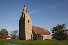
St James' church, Dry Doddington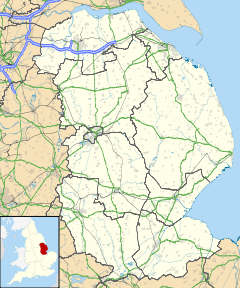
 Dry Doddington
Dry Doddington shown within LincolnshireOS grid reference SK850466 Parish Westborough and Dry Doddington District South Kesteven Shire county Lincolnshire Region East Midlands Country England Sovereign state United Kingdom Post town Newark Postcode district NG23 Police Lincolnshire Fire Lincolnshire Ambulance East Midlands EU Parliament East Midlands UK Parliament Sleaford and North Hykeham List of places: UK • England • Lincolnshire Dry Doddington is a small village in the north-west of the South Kesteven district of Lincolnshire, England. It lies about 6 miles (9.7 km) south east of Newark and about 9 miles (14 km) from Grantham.
Contents
Geography
The village, on a small hill called Lincoln Hill, is surrounded by the River Witham to the west and south. Claypole is to the north and Westborough and Long Bennington 1 mile (1.6 km) to the south. The East Coast Main Line passes 1 mile (1.6 km) to the north-east.
History
Dry Doddington means the dry estate of a man called Dodda. There was a deserted medieval village named Stocking or Stockyng associated with Dry Doddington in the early 14th century; its precise location is unknown.[1]
Dry Doddington CE School was built as a National School in 1872, but was closed between 1926 and 1929, after which it re-opened as a primary school. It closed its doors for the last time in 1961.[2]
Today, the village forms part of the civil parish of Westborough and Dry Doddington, which had a population of 335 in 2001. Prior to 1931, Dry Doddington was a separate parish.[3]
The village public house is The Wheatsheaf Inn on Main Street.[4]
The Church of St James
The parish church is dedicated to St James, which has a west-ward leaning tower. It is a grade II* listed building dating from the 12th century, with an early 14th century tower. It was restored in 1876.[5][6]
The church contains a memorial to the 49 Squadron Avro Lancaster that crashed near the village on 26 November 1944. The aircraft, called ‘O-Oboe’, was piloted by F/O Le Marquand (PB432). It had only been in the air for a few minutes before it crashed, laden with bombs and fuel. Whilst five members of the crew survived, Norman Langley, the wireless operator and air gunner, and Edward Blake, the mid-upper gunner, were killed.[7]
References
- ^ "Stocking deserted medieval village". Lincs to the Past. Lincolnshire Archives. http://www.lincstothepast.com/Stocking-Deserted-Medieval-Village/236885.record?pt=S. Retrieved 2 July 2011.
- ^ "Dry Doddington CE School". Lincs to the Past. Lincolnshire Archives. http://www.lincstothepast.com/DRY-DODDINGTON-CE-SCHOOL/727430.record?pt=S. Retrieved 2 July 2011.
- ^ "Dry Doddington". Vision of Britain. University of Portsmouth. http://www.visionofbritain.org.uk/relationships.jsp?u_id=10410423&c_id=10001043. Retrieved 2 July 2011.
- ^ "The Wheatsheaf", geograph.org.uk. Retrieved 22 July 2011
- ^ "St James, Dry Doddington". Pastscape. English Heritage. http://www.pastscape.org.uk/hob.aspx?hob_id=323937&sort=4&search=all&criteria=Dry%20Doddington&rational=q&recordsperpage=10. Retrieved 2 July 2011.
- ^ "St James Dry Doddington". National Heritage List for England. English Heritage. http://list.english-heritage.org.uk/resultsingle.aspx?uid=1253449. Retrieved 2 July 2011.
- ^ "Dry Doddington Memorial". Bomber History. Malcolm Brooke/49 Squadron Association. http://www.bomberhistory.co.uk/49squadron/Memorials/Memorial_Doddington.html. Retrieved 2 July 2011.
External links
Categories:- South Kesteven
- Church of England churches in Lincolnshire
- Grade II* listed buildings in Lincolnshire
- Villages in Lincolnshire
- Lincolnshire geography stubs


Wikimedia Foundation. 2010.