- P.W. & B. Railroad Bridge
-
P.W. & B. Railroad Bridge 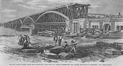
Construction of the bridge is almost complete in this 1866 newspaper illustration.Crosses Susquehanna River Locale (ruins) Havre de Grace, Maryland and Perryville, Maryland Design Wood truss bridge, with later iron reinforcements Total length 3,269 feet (996 m)[1]:116 Number of spans 13 (including center draw span)[1]:116 Opened November 26, 1866[2] Closed 1906 (as a railroad bridge);[3] 1940 (as a highway bridge) Coordinates 39°33′17″N 76°05′01″W / 39.55472°N 76.08361°W The P.W. & B. Railroad Bridge was the first bridge over the Susquehanna River built by the Philadelphia, Wilmington and Baltimore Railroad in 1866 as part of the first mainline railroad between Philadelphia and Baltimore. The bridge was replaced by the Amtrak Susquehanna River Bridge in 1906.
History
The PW&B began operating its main line in 1838, using a ferry operation to transport railroad cars over the Susquehanna.[4]
Construction of the bridge, a wood truss design, began in 1862. The masonry and most of the wooden spans were complete in 1866, but then a tornado severely damaged the wooden components on July 25, 1866. Repairs were made quickly and the first locomotive crossed the bridge on November 20, 1866. The cost of construction, including rebuilding most of the truss portions, was $2.3 million. Passenger trains began service on November 26, 1866.[2]
The PW&B later replaced the wooden spans with iron spans. A draw span was installed in the late 1870s.[2]
The Pennsylvania Railroad took control of the PW&B in 1881. It built a new bridge during 1904 to 1906.[3]
References
- ^ a b Roberts, Charles S.; David W. Messer (2003). Triumph VI: Philadelphia, Columbia, Harrisburg to Baltimore and Washington DC: 1827-2003. Baltimore, Maryland: Barnard, Roberts, and Co., Inc.. ISBN 0-934118-28-0.
- ^ a b c Wilson, William B. (1895). History of the Pennsylvania Railroad Company. Philadelphia: Henry T. Coates & Co. pp. 310–311. http://books.google.com/books?id=qj9N-eWi71YC&dq=wilson%20history%20pennsylvania%20railroad&pg=PA310#v=onepage&q&f=false.
- ^ a b Baer, Christopher T. "PRR Chronology: 1906". http://www.prrths.com/Hagley/PRR1906%20Mar%2005.pdf. Retrieved 2008-12-27.
- ^ Herbert W. Harwood, Jr.. "Philadelphia, Wilmington & Baltimore Railroad". Maryland Online Encyclopedia. Maryland Historical Society. http://www.mdoe.org/phil_wil_balt_rr.html. Retrieved 2010-05-12.
Bridges of the Susquehanna River Upstream
Amtrak Susquehanna River BridgeP.W. & B. Railroad Bridge Downstream
Chesapeake Bay Bridge (Chesapeake Bay)

 Categories:
- Bridges over the Susquehanna River
- Havre de Grace, Maryland
- Philadelphia, Baltimore and Washington Railroad
- Railroad bridges in Maryland

Wikimedia Foundation. 2010.