- Dong Phaya Yen Mountains
-
Dong Phayayen - Khao Yai Forest Complex * UNESCO World Heritage Site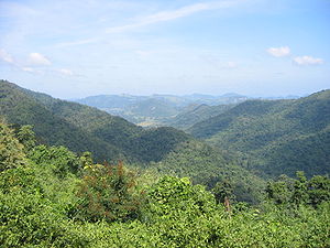
Country Thailand Type Natural Criteria X Reference 590 Region ** Asia-Pacific Inscription history Inscription 2005 (29th Session) * Name as inscribed on World Heritage List
** Region as classified by UNESCO Mountain ranges in Central and northeastern Thailand
Dong Phaya Yen (Thai: ดงพญาเย็น, Thai pronunciation: [doŋ pʰajaː jen], lit. Jungle of the Ice Lord) is a mountain range in central Thailand.
Contents
Description
Dong Phaya Yen is the southeastern extension of the Phetchabun mountains, dividing the Chao Phraya river valley of Central Thailand and the Khorat Plateau of the northeast. The mountain chain reaches a maximum altitude of 1,351 m above sea level at Khao Rom, its highest hill.
The range has a length of about 230 km. The southern arm of the Dong Phaya Yen Mountains is the Sankamphaeng Range, that merges with the Dângrêk Mountains on its eastern end.[1] The mountains are drained to the north by several tributaries to the Mun River, while the south drains into the Prachinburi River.
History
Dong Phaya Yen was once known as Dong Phaya Fai or "Jungle of the Fire Lord" because this area was once the vast forest where malaria killed most travelers who dared to pass through the woods.
Much of the forest cover, however, was destroyed since the beginning of 20th century. Following the deforestation of the area, Vice King (Uparaja) Pinklao changed the name of the forest from Dong Phaya Fai to Dong Phaya Yen to imply that "the wild forest has been tamed".
Protected areas
Several national parks are located in the mountains. The most famous one is the Khao Yai National Park, which was the first national park of Thailand. Other parks are the Ta Phraya National Park at the boundary with Cambodia, the Thap Lan National Park, Pang Sida National Park, Phra Phutthachai National Park and the Dongyai Wildlife Sanctuary. Altogether 6155 km² are protected in these parks.
In 2005 the forests of the Dong Phaya Yen mountains were inscribed on the UNESCO World Heritage List under the name Dong Phaya Yen – Khao Yai Forest Complex.
See also
References
External links
- Khao Yai National Park
- New Liphistius species (Araneae, Mesothelae) from western and eastern Thailand
Coordinates: 14°19′48″N 102°03′00″E / 14.330°N 102.050°E
Historic City of Ayutthaya · Ban Chiang Archaeological Site · Dong Phayayen-Khao Yai Forest Complex · Historic Town of Sukhothai and Associated Historic Towns · Thungyai-Huai Kha Khaeng Wildlife Sanctuaries
 Categories:
- World Heritage Sites in Thailand
- Mountain ranges of Thailand


Wikimedia Foundation. 2010.