- Clarkson, Nebraska
-
Clarkson, Nebraska — City — Downtown Clarkson: east side of Pine Street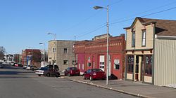 Location of Clarkson, Nebraska
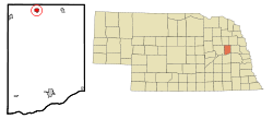
Coordinates: 41°43′29″N 97°7′23″W / 41.72472°N 97.12306°WCoordinates: 41°43′29″N 97°7′23″W / 41.72472°N 97.12306°W Country United States State Nebraska County Colfax Area – Total 0.7 sq mi (1.8 km2) – Land 0.7 sq mi (1.8 km2) – Water 0.0 sq mi (0.0 km2) Elevation 1,496 ft (456 m) Population (2000) – Total 685 – Density 999.3/sq mi (385.8/km2) Time zone Central (CST) (UTC-6) – Summer (DST) CDT (UTC-5) ZIP code 68629 Area code(s) 402 FIPS code 31-09200[1] GNIS feature ID 0828161[2] Clarkson is a city in Colfax County, Nebraska, United States. The population was 685 at the 2000 census.
Contents
Geography
Clarkson is located at 41°43′29″N 97°7′23″W / 41.72472°N 97.12306°W (41.724676, -97.123015)[3].
According to the United States Census Bureau, the city has a total area of 0.7 square miles (1.8 km2), all of it land.
Clarkson is located in Northeast Nebraska, three miles west of the junction of Nebraska Highways 15 and 91. Clarkson lies 35 miles southeast of Norfolk, Nebraska; 35 miles northeast of Columbus, Nebraska; 85 miles northwest of Omaha, Nebraska; and 90 miles northwest of Lincoln, Nebraska.
Demographics
As of the census[1] of 2000, there were 685 people, 311 households, and 185 families residing in the city. The population density was 999.3 people per square mile (383.3/km²). There were 366 housing units at an average density of 533.9 per square mile (204.8/km²). The racial makeup of the city was 99.12% White, 0.73% from other races, and 0.15% from two or more races. Hispanic or Latino of any race were 1.31% of the population.
There were 311 households out of which 25.7% had children under the age of 18 living with them, 53.7% were married couples living together, 4.8% had a female householder with no husband present, and 40.5% were non-families. 38.9% of all households were made up of individuals and 23.2% had someone living alone who was 65 years of age or older. The average household size was 2.20 and the average family size was 2.95.
In the city the population was spread out with 24.4% under the age of 18, 6.3% from 18 to 24, 25.1% from 25 to 44, 18.1% from 45 to 64, and 26.1% who were 65 years of age or older. The median age was 41 years. For every 100 females there were 86.1 males. For every 100 females age 18 and over, there were 83.7 males.
The median income for a household in the city was $26,726, and the median income for a family was $36,094. Males had a median income of $25,625 versus $20,938 for females. The per capita income for the city was $14,189. About 6.5% of families and 9.1% of the population were below the poverty line, including 8.1% of those under age 18 and 15.5% of those age 65 or over.
Economy
Economic activities in Clarkson include farming, cattle, and hog feeding, nursery, and retail and wholesale sales. Clarkson is also home to the largest perennial grower in the midwest — Bluebird Nursery.
Economic progress in Clarkson since 1995 includes several expansions of Bluebird Nursery and the construction of a new concession stand in the City Park. The Opera House is now managed by the Clarkson Community Opera House, Inc. organization, founded in 2002. The current organization expects to maintain the Opera House as a viable facility on Main Street. The Physicians Clinic is now Alegent Health Clarkson Clinic. A new medical clinic building is currently in use.
Government
County Government
Colfax County is governed by three county commissioners who are elected by popular vote to four-year terms. Colfax County belongs to the Northeast Nebraska Economic Development District along with 12 other counties.
Municipal Government
Clarkson, a second-class city, is governed by a mayor-council form of government who are elected to four-year terms. For further information contact the city clerk's office at (402) 892-3100.
Fire Protection
Fire protection in the community is provided by a 44 member volunteer fire department. The Rural Fire Protection District provides fire protection for areas outside the community limits. The rescue squad has two units staffed by 23 EMTs, nine first responders, and one paramedic. They recently took delivery of a 2007 Medtec 4X4 Ambulance from Midwest Vehicle Professionals in York, NE. It's a very nice piece.
Law Enforcement
Clarkson employs one full-time certified policeman who has a patrol car, radio communications and other standard equipment. For emergencies dial: 911 and for non-emergencies dial: Clarkson Police Department at (402) 892-3111 or Colfax County Sheriff at (402) 352-8514.
Points of interest
- Clarkson Public Library
- Clarkson Historical Museum
- Clarkson Opera House
- Memorial Park
- Bohemian National Garden
- Clarkson City Park
References
- ^ a b "American FactFinder". United States Census Bureau. http://factfinder.census.gov. Retrieved 2008-01-31.
- ^ "US Board on Geographic Names". United States Geological Survey. 2007-10-25. http://geonames.usgs.gov. Retrieved 2008-01-31.
- ^ "US Gazetteer files: 2010, 2000, and 1990". United States Census Bureau. 2011-02-12. http://www.census.gov/geo/www/gazetteer/gazette.html. Retrieved 2011-04-23.
External links
Municipalities and communities of Colfax County, Nebraska Cities Clarkson | Schuyler

Villages Categories:- Cities in Nebraska
- Populated places in Colfax County, Nebraska


Wikimedia Foundation. 2010.