- Middelharnis
-
Middelharnis — Municipality — 
Flag
Coat of arms
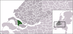
Coordinates: 51°45′N 4°10′E / 51.75°N 4.17°ECoordinates: 51°45′N 4°10′E / 51.75°N 4.17°E Country Netherlands Province South Holland Area - Total 86.79 km2 (33.5 sq mi) - Land 61.16 km2 (23.6 sq mi) - Water 25.63 km2 (9.9 sq mi) Time zone CET (UTC+1) - Summer (DST) CEST (UTC+2) Website www.middelharnis.nl  Middelharnis (population: about 18,000 in 2009) is a municipality and a village in the western Netherlands, in the province of South Holland. The municipality covers an area of 86.79 km² (of which 25.63 km² water).
The municipality consists of the following population centres:
- Battenoord
- Middelharnis (6,200 inh.)
- Nieuwe-Tonge (2,800 inh.)
- Sommelsdijk (7,400 inh.)
- Stad aan 't Haringvliet (1.400 inh.)
On 1 January 1966, the municipalities of Nieuwe-Tonge, Sommelsdijk, and Stad aan 't Haringvliet were added to Middelharnis.
Middelharnis has a shopping area called D'n Diek. This shopping center settled itself on a dike which used to be the last barrier for the towns from the Haringvliet. The village hosts a public and Christian high school. Middelharnis has an inland harbor with connection to the Haringvliet. There is also a small beach which can get very crowded in the summertime. The old main street in both villagses are very pretty. Starting at the church and ending at the harbor, they are very identical. In Middelharnis the old main street has the old municipality building. Both towns have the church in the center and the rest of the towns sort of vane out from this center. In Sommelsdijk a sportcomplex with swimming pool is present called De Staver. Stad aan 't Haringvliet has a small harbor with beach. Like most of the towns on the island the old windmill has been preserved. Nieuwe Tonge's main entry roads are the two dikes that form the edges of the town. And of course a traditional windmill is present.
 This is not Prinses Margrietstraat but Visserdijk in Middelharnis.
 Het Laantje van Middelharnis (Avenue of Middelharnis) by Meindert Hobbema (1689).
External links
Categories:- Municipalities of South Holland
- Populated places in South Holland
- South Holland geography stubs


Wikimedia Foundation. 2010.