- Mid-Western Highway
-
Mid-Western Highway 
![Proposed to replace [1]](/pictures/enwiki/50/200px-Mandurama_Mid-Western_Highway_Sign.JPG)
Proposed _ _to_replace_  _to_replace_
 to replace
  [1]
[1]Length 522 km (324 mi) Direction East-West From  Great Western Highway / Mitchell Highway, Bathurst, New South Wales
via Blayney, Cowra, Grenfell, West Wyalong, Rankins Springs, Goolgowi To  Cobb Highway,
Hay, New South WalesAllocation Marsden - West Wyalong: (duplex with )
)Major junctions  Canowindra Road
Lachlan Valley Way
 Olympic Highway
Lachlan Valley Way
Henry Lawson Way
 Newell Highway
 Goldfields Way
Newell Highway
 Kidman Way
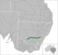
The Mid-Western Highway starts at Bathurst New South Wales, where it joins with the Great Western Highway over the Blue Mountains from Sydney. It proceeds via Blayney, Carcoar and Cowra. It then heads west through Grenfell to West Wyalong where it crosses the Newell Highway. It continues west to Rankins Springs and then to Hay where it joins the Sturt Highway.
The Mid-Western Highway is the most direct route between Sydney and Adelaide, however since the Hume Highway has been improved, the route via the Hume Highway and Sturt Highway through Wagga Wagga is probably superior and quicker despite being around 20km longer. The latter is also part of the Auslink National network as the defined route from Sydney to Adelaide.
See also
- Highways in Australia
- List of highways in New South Wales
References
- ^ Alpha-Numeric Route Numbering for NSW. It is here!, Ozroads: the Australian Roads Website. Retrieved on December 29, 2007.
Categories:- Highways in New South Wales
- Australia road stubs

![Proposed to replace [1]](/pictures/enwiki/77/Mandurama_Mid-Western_Highway_Sign.JPG)


Wikimedia Foundation. 2010.