- Cobb Highway
-
Cobb Highway 
Proposed _to_replace_  to replace
  [1]
[1]Length 598 km (372 mi) Direction North-South From  Barrier Highway, Wilcannia, New South Wales
via Ivanhoe, Booligal, Hay, Deniliquin To  Northern Highway, Moama, NSW / Echuca, Victoria (NSW/Vic Border)
Major junctions  Mid-Western Highway
 Sturt Highway
 Riverina Highway
for full list see major intersections
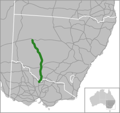
The Cobb Highway is a State highway in western New South Wales, Australia. From north to south the Cobb Highway begins at its junction with the Barrier Highway near Wilcannia and runs south through the townships of Ivanhoe, Booligal, Hay and Deniliquin. It ends at Moama where the highway crosses the New South Wales/Victoria border at the Murray River and continues south through Victoria as the Northern Highway.
The Cobb Highway was named after Cobb and Co, a company which ran a network of stagecoaches in inland Australia in the latter half of the 19th century and early in the 20th century. The highway follows an old coach route through the Riverina, connecting the Murray, Murrumbidgee and Lachlan Rivers, and across the intervening plains to the Darling River at Wilcannia. The Cobb Highway is sealed as far north as 10 km north of Ivanhoe. It is one of the most remote and could be one of the least-used of the highways of New South Wales.
The highway travels through diverse changes in scenery, from the Murray River, enclosed farming land in the Riverina, to open grazing land and semi-desert towards the middle and northern sections. The speed limit is posted at 100 km/h except from three sections where the limit is 110 km/h, being: 40 km north of Deniliquin until Hay, Hay until a few kilometres north of Booligal and the final 110 km/h zone being from just south of Mossgiel to Ivanhoe.
Contents
History
In the 1930s the road now known as the Cobb Highway was proclaimed as part of State Highway 21, which also included the road north through Wilcannia, White Cliffs and Tibooburra to Warri Gate at the Queensland border.
Highway 21 was truncated 18 kilometres south of Wilcannia on 9 February 1945 when the Silver City Highway was proclaimed. The Cobb Highway received its name in 1947 in commemoration of the Cobb & Co. coach company.
In 1954, with the institution of the National Route system, the Cobb Highway in NSW and the Northern Highway in Victoria were designated to be National Route 75.
In May 1969 a bridge over the Edward River at Deniliquin was constructed (replacing a timber bridge built in 1895). In June 1973 a bridge over Murrumbidgee River at Hay was built (replacing the 1874 opening bridge).[2]
The Long Paddock project
The Cobb Highway is part of a very significant Travelling Stock routes network that traverses New South Wales. This highway is the focus of a major tourism initiative entitled 'The Long Paddock', developed by the shires along the route (Murray, Deniliquin, Conargo, Hay and Central Darling). The Long Paddock project aims to create sustainable communities along the Cobb Highway through the development of a dynamic cultural heritage touring route. The project uses the consistent theme of transportation, involving elements of history, creative interpretation and local environment, to link the communities along the highway.[3]
Major intersections and towns
Cobb Highway 
Northbound Distance to
Wilcannia
(km)Distance to
Melbourne
(km)Southbound  Crossroads (clockwise from highway)
Barrier Highway to Wilcannia and Broken Hill
Barrier Highway to Cobar and DubboEnd Cobb Highway 
20 793 Start Cobb Highway Menindee
Ivanhoe-Menindee Road178 635 Menindee
Ivanhoe-Menindee RoadIvanhoe 182 631 Ivanhoe Balranald
Balranald Road182.5 630.5 Balranald, Swan Hill
Balranald RoadCobar
Behring Street183 630 Cobar
Behring StreetBROKEN HILL RAIL LINE

185 628 BROKEN HILL RAIL LINE
Hillston
Mossgiel Trunk Road233 580 Hillston, Griffith
Mossgiel Trunk RoadHillston, Cobar, Bourke
Lachlan Valley Way315 498 Hillston
Lachlan Valley Waycontinues as 392 421 Goolgowi, West Wyalong, Bathurst, Sydney
Mid-Western Highway
Goolgowi, West Wyalong, Bathurst, Sydney
Mid-Western Highway continues as Maude
Cadell Street392.5 421.5 Maude
Cadell StreetHay 393 420 Hay MURRUMBIDGEE RIVER 394 419 MURRUMBIDGEE RIVER continues as 395 418 Narrandera, Wagga Wagga, Sydney;
Balranald, Mildura, Adelaide
Sturt Highway

Balranald, Mildura, Adelaide;
Narrandera, Wagga Wagga, Sydney
Sturt Highway End
continues asJerilderie
Jerilderie Road402 411 Jerilderie
Jerilderie RoadMoulamein
Moulamein Road499 314 Moulamein
Moulamein RoadFinley, Berrigan, Albury
Riverina Highway
516 297 Finley, Berrigan, Albury
Riverina Highway Deniliquin 517 296 Deniliquin Barham, Kerang
Deniliquin-Barham Road518 295 Barham, Kerang
Deniliquin-Barham RoadMathoura 550 263 Mathoura Barmah, Nathalia
Barmah Road576 237 Barmah, Nathalia
Barmah RoadWomboota
Perricoota Road590 223 Womboota
Perricoota RoadMoama 591 222 Moama Start Cobb Highway
from Northern Highway
592 221 End Cobb Highway MURRAY RIVER MURRAY RIVER NEW SOUTH WALES
STATE BORDER
VICTORIA592 221 continues as Northern Highway
to Echuca / Bendigo / MelbourneSee also
- Highways in Australia
- List of highways in New South Wales
References
- ^ Alpha-Numeric Route Numbering for NSW. It is here!, Ozroads: the Australian Roads Website. Retrieved on December 29, 2007.
- ^ National Route 75: Cobb Highway, Ozroads: the Australian Roads Website (accessed 22 January 2007).
- ^ The Long Paddock: Cobb Highway Touring Route
External links
Categories:- Australian highways
- Highways in New South Wales


Wikimedia Foundation. 2010.