- Metroad 1
-
Metroad 1
Route information Length: 64 km (40 mi) Existed: October 1993 – present Major junctions north end: Pennant Hills Road (Metroad 7) and Pacific Highway (State Route 83) at Pearces Corner, Wahroonga south end: Princes Highway (State Route 60) and Southern Freeway (National Route 1) at Waterfall Highway system Highways in Australia
National Highway • Freeways in Australia
Highways in New South WalesMetroad 1 is a Metroad in Sydney, New South Wales, Australia. It replaced National Route 1, from Metroad 7 at Pearces Corner in Wahroonga south-east to the CBD then from the CBD south-west to the F6 Southern Freeway at Waterfall in October 1993.
Route
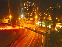 The M1 going through Sydney
Metroad 1 changes names several times as it passes through the city. Its names from Wahroonga to Waterfall are: Pacific Highway, Gore Hill Freeway, Warringah Freeway, Sydney Harbour Tunnel, Cahill Expressway, Eastern Distributor, Southern Cross Drive, General Holmes Drive, The Grand Parade, President Avenue, Princes Highway, Acacia Road, Princes Highway. The section between (and inclusive of) Gore Hill Freeway and General Holmes Drive (junction with M5 East Fwy) is freeway grade.
Major intersections
From north to south, the major intersections are:
- Pacific Highway / Sydney-Newcastle Freeway / Cumberland Highway
Pacific Highway
- Mona Vale Road / Ryde Road (Metroad 3)
- Boundary Street
- Fullers Road
- Pacific Highway / Longueville Road / Lane Cove Tunnel (Metroad 2)
Gore Hill Freeway
Warringah Freeway- Miller Street
- Falcon Street / Military Road (Metroad 10)
- Bradfield Highway
Sydney Harbour Tunnel
- Cahill Expressway
Cahill Expressway Eastern Distributor
- William Street
- Cleveland Street
Southern Cross Drive
- Wentworth Avenue
- Botany Road
General Holmes Drive
- Foreshore Road
- M5 East Freeway (Metroad 5)
The Grand Parade
- Bay Street
- The Grand Parade
President Avenue
Princes Highway- Princes Highway
- Rocky Point Road
- King Georges Road (Metroad 3)
- Port Hacking Road
- Kingsway
- Old Princes Highway
- Heathcote Road
- Old Princes Highway / Southern Freeway
Sydney Metroads Road infrastructure in Sydney Motorways / Tollways Freeways / Expressways Cahill Expressway • Gore Hill Freeway • Southern Cross Drive • Southern Freeway • M5 East • Sydney–Newcastle Freeway • Warringah Freeway • Western Distributor • General Holmes DriveMetroads Bridges and Tunnels Vehicle Ferries Conceptual Plans Sydney Orbital Network • Sydney Bypasses (past, present and proposed)Other M4 East (proposed) • Marrickville Tunnel (proposed) • North Western Expressway (abandoned) • F3 to Sydney Orbital (proposed) • F6 to Marrickville Tunnel (proposed)Categories Streets in Sydney • Highways in SydneyOperators Transport in Sydney Categories:- Sydney Metroads
- 1993 establishments in Australia
- Australia road stubs


Wikimedia Foundation. 2010.