- Berlin Görlitzer Bahnhof
-
For the U-Bahn station, see Görlitzer Bahnhof (Berlin U-Bahn).

Berlin Görlitzer Bahnhof 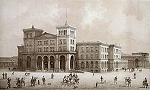
„Empfangsgebäude des Görlitzer Bahnhofes in Berlin” an 1872 painting depicting the station entrance hall Operations Category Construction and location Location Berlin State Berlin Country Germany Local authority Friedrichshain-Kreuzberg List of railway stations in the Berlin area Görlitzer Bahnhof was the name of the Berlin railway terminus for the mainline link between the capital, Cottbus in Brandenburg and Görlitz in Lower Silesia (since 1945 Saxony). It stood overlooking Spreewaldplatz in the eastern part of Kreuzberg but wartime bombing and Cold War tensions led to its closure and eventual demolition.
The Görlitzer Bahnhof (Berlin U-Bahn) station was named after this historic station and is located on a different site nearby.
Contents
The rise
The station was designed by August Orth, an architect later responsible for the Emmauskirche in nearby Lausitzer Platz, and built between 1865 and 1867 in the Palazzo style of the Italian Renaissance. It formed part of a railway expansion project that would link Berlin with Cottbus and Görlitz, and then ultimately with cities such as Sagan (Żagań) and Breslau (Wrocław) (both in Poland since 1945) and Vienna in Austria.
On 13 June 1866 a military train bound for the Austro-Prussian war became the first train to leave the as yet incomplete station site. The connection was one of convenience because the military had built their barracks in neighbouring Wrangelstrasse.
Shortly afterwards, on 13 September, a regular passenger service began between Berlin and Cottbus. By late 1867 the Berlin-Görlitz line was complete and the route, which passed through the countryside of the Spreewald and the Niederlausitz and the towns of Königs Wusterhausen, Lübben and Lübbenau, was officially opened on 31 December 1867. Although originally founded by a private company, owned by industrialist and rail king Bethel Henry Strousberg, the service was nationalised on 28 March 1882.
The new line proved an immediate success with passengers. After only a few months, the line was accommodating 70,000 travellers a day and during the whole of 1880, approximately 1,5 million people used Görlitzer Bahnhof. Its popularity had a stimulating effect on the surrounding area, with shops and cafés springing up in the neighbouring streets, helping to establish it as one of the liveliest in the city.
Aside from the transport of people, the line also served as a vital trade route connecting the capital with the cloth factories, brick and glass works of industrial Görlitz. Lausitz proved to be not only a rich source of Spreewald gherkins but also, more importantly, of coal.
 A section of the 1902 Pharus Plan of Berlin showing Goerlitzer Bahnhof and the eastern Kreuzberg environs
Görlitzer Tunnel
In order to improve access between the neighbourhoods that emerged around Görlitzer Straße (the Wrangelkiez) and Wiener Straße (the Reichenberger Kiez), an underpass was constructed under the railway site. Opened to the public in 1910, this connected Oppelner Straße on the northern side with Liegnitzer Straße to the south.[1] This was known as the ‘Görlitzer Tunnel’, although it would later also acquire the nickname "Harnröhre“ (Urethra).
The fall
During the World War II, the Allied aerial bombardments of 3 February 1945, that left 3,255 dead or missing and over 119,000 homeless in the surrounding Kreuzberg district, meted out severe damage to the station. Nevertheless by June, a mere month after the surrender of Berlin, a makeshift Görlitzer Bahnhof was back in service.[2]
The revival proved temporary however. From 25 September 1946 all its long distance trains were redirected to Schlesischer Bahnhof (renamed Ostbahnhof in 1950) on the central Stadtbahn. Furthermore over the next few years the ongoing expansion of the electric S-Bahn system would supersede its role in the local network too. Ultimately though, it was the deepening crisis in political relations between East and West that sealed the station’s fate, and made its position as a Western station operating an Eastern line untenable. It therefore came as no surprise when the GDR decided to close Görlitzer Bahnhof to passenger trains on 29 April 1951.
Although the complete absence of the railway on the 1954 Berlin city map suggests the station was subsequently demolished and cleared, it actually remained relatively undisturbed in its bombed-out state for ten years after the closure. The arrival of the Wall in 1961, however, quashed any hopes of a reconstruction.
Over the following decade or so all the remaining station buildings were demolished, beginning with the large platform hall in 1962 and the main reception area in 1967.
The remaining public buildings – which were substantial enough to include two towers, various waiting rooms and a restaurant – were levelled in 1975 during a wave of city clear up during the 70s that claimed many historic victims across the city. At the time the reasons for demolition was given that the buildings served no practical purpose in standing empty and as a result were being occupied by an “anti-social” element. The removal of these “ruins” would therefore be better for the image of West Berlin.[3] By 1976 the site lay mostly empty.
Continuing use of Görlitzer Bahnhof after closure
Although the station stood abandoned and the site lay undeveloped for over thirty years, the area was never dormant. Since the closure in 1951, the land and buildings were used variously for coal storage, as a scrapyard, an auto garage and for other small enterprises. Also the goods line and sheds were used for transporting freight between West and East Berlin up until 1986, and for this reason a border crossing point stood on the bridge over the Landwehrkanal.
Furthermore the northern goods part of the station site remained in active use by the Deutsche Reichsbahn for transporting freight between West and East Berlin, and for this reason a border crossing point stood on the bridge over the Landwehrkanal. This passage of freight was permanently discontinued on June 30, 1985.[1]
Between the years 1984-87 a local swimming baths, the Spreewald Bad, an innovative structure designed by Christoph Langhof architects, was built on the site of the former station.
Before the remaining area from Skalitzer Strasse up to the Görlitzer Ufer was developed into Görlitzer Park in the early 1990s,[4] it was a waste ground partly accessible by the public. This vacancy led to the site being occupied during the summer of 1989 by the Mutoid Waste Company, an anarchist art commune from London. The location was chosen in part because of its proximity to the Wall. On one memorable occasion the scrap metal artists created a "Peace Bird" contraption with a bird suspended high in the air which was able to roll along the railway tracks to the border point on the bridge and, in a gesture of peace towards the GDR, exhibit the bird to those in the east.[5]
Although the Görlitzer Tunnel remained in use until the beginning of the 90s, the public access to the site prompted by the new park left it redundant. In the creation of a ‘natural’ arena in the centre of the park the tunnel was destroyed, although not completely with its remains incorporated into the design.
The remains
 The remaining office building and one of the goods sheds.
The only obvious physical remains of the station site are the two goods sheds, an old office building, the railway bridge and the remnants of the underpass visible in a crater in the centre of the park. Nevertheless it is possible to follow part of the old railway route on foot, as it leads out of the park, over the Landwehrkanal and then comes to an end over Elsenstrasse in Treptow, just before the original line would have met the ring of the S-bahn.
The historic building itself lives on in existing local names. In 1926 the local U-bahn station Oranienstrasse was renamed Görlitzer Bahnhof to indicate the neighbouring mainline terminus but despite the latter’s demise the U-bahn stop maintains the historical name, much like with the similarly doomed Anhalter Bahnhof. In addition to this, the road that runs alongside the western side of Görlitzer Park, was renamed Wiener Straße in 1873 because the first trains connecting Berlin and the Austrian capital Wien (Vienna) left from Görlitzer Bahnhof. Likewise, the neighbouring squares Spreewaldplatz and Lausitzerplatz were named after the areas of countryside once accessible from its platforms.
References
- ^ a b Berliner-unterwelten.de Berliner Unterwelten e.V. (German)
- ^ "History of Görlitzer Bahnhof", www.goerlitzer-bahnhof.de (German)
- ^ Kreuzberger-chronik.de (German)
- ^ Morgenpost.de Berliner Morgenpost, 29. April 2007 (German)
- ^ Mutoid Waste Company im Sommer 1989 in West Berlin Tip, 21. Aug 2009 (German)
Former railway termini in Berlin  Anhalter Bahnhof • Dresdner Bahnhof • Görlitzer Bahnhof • Hamburger Bahnhof • Lehrter Bahnhof • Old Nordbahnhof • Old Ostbahnhof • Potsdamer Bahnhof • Schlesischer Bahnhof • Stettiner Bahnhof • Wriezener Bahnhof
 Categories:
- Buildings and structures completed in 1867
- Destroyed landmarks
- History of Berlin
- Railway stations in Berlin
- Buildings and structures in Friedrichshain-Kreuzberg


Wikimedia Foundation. 2010.