- Ostrov (Karlovy Vary District)
-
For other uses of "Ostrov", see Ostrov (disambiguation).
Ostrov Ostrov nad Ohří Town 
 Flag
Flag Coat of arms
Country Czech Republic Region Karlovy Vary District Karlovy Vary Commune Ostrov Elevation 398 m (1,306 ft) Coordinates 50°18′30″N 12°56′52″E / 50.30833°N 12.94778°E Area 50.42 km2 (19.47 sq mi) Population 16,999 (September, 2009) Density 337 / km2 (873 / sq mi) First mentioned 13th century Mayor Pavel Čekan Timezone CET (UTC+1) - summer (DST) CEST (UTC+2) Postal code 363 01 

 Location in the Czech Republic
 Location in Karlovy Vary District
Wikimedia Commons: Ostrov Statistics: statnisprava.cz Website: www.ostrov.cz Ostrov (Czech pronunciation: [ˈostrof]; German: Schlackenwerth), is a town in the Carlsbad Region, Czech Republic. It is located at a foothill of the Ore Mountains about 10 km northeast of Karlovy Vary and has a population of 16,999 (September, 2009). The origin of the settlement named Zlaukowerde (Slávek's Island) at the confluence of Bystřice and Jáchymovský Creeks traces back to the beginning of the 13th century. The town charter for Ostrov was issued by Bohemian king John the Blind in 1331. The population of Ostrov multiplied after WWII with a boom of uranium mining in nearby Jáchymov. The extensive housing blocks from the 1950s forming the new part of Ostrov are considered one of the best examples of socialist realism architecture in the Czech Republic. The town was known for production of Škoda trolleybuses for many decades, but this ended in 2004.
-

Ostrov Gallery
-
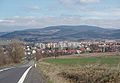
View on town from south
External links
- (Czech) Official website of the town
Towns and villages of Karlovy Vary District Abertamy • Andělská Hora • Bečov nad Teplou • Bochov • Boží Dar • Božičany • Březová • Černava • Čichalov • Dalovice • Děpoltovice • Hájek • Horní Blatná • Hory • Hroznětín • Chodov • Chyše • Jáchymov • Jenišov • Karlovy Vary • Kolová • Krásné Údolí • Krásný Les • Kyselka • Merklín • Mírová • Nejdek • Nová Role • Nové Hamry • Ostrov • Otovice • Otročín • Pernink • Pila • Potůčky • Pšov • Sadov • Smolné Pece • Stanovice • Stráž nad Ohří • Stružná • Šemnice • Štědrá • Teplička • Toužim • Útvina • Valeč • Velichov • Verušičky • Vojkovice • Vrbice • Vysoká Pec • Žlutice • Military Area Hradiště

This Karlovy Vary Region location article is a stub. You can help Wikipedia by expanding it. -