- Mount Edziza
-
Mount Edziza 
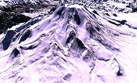
Elevation 2,787 m (9,144 ft) Prominence 1,750 m (5,741 ft) Listing List of volcanoes in Canada List of Ultras in Canada Location Location British Columbia, Canada Range Tahltan Highland Coordinates 57°42′56.0″N 130°38′04.0″W / 57.71556°N 130.63444°WCoordinates: 57°42′56.0″N 130°38′04.0″W / 57.71556°N 130.63444°W Topo map NTS 104G/10 Geology Type Stratovolcano Age of rock Pleistocene-to-Holocene Volcanic arc/belt Northern Cordilleran Volcanic Province Last eruption 1340 BP Mount Edziza is a stratovolcano in the Stikine Country of northwestern British Columbia, Canada. The volcano and the surrounding area are protected within Mount Edziza Provincial Park. It consists of a complex of multiple peaks and ridges, with several glaciers flowing in all directions. The summit is topped by an ice-filled caldera, which is almost 2 km (1 mi) wide. The three main peaks around the summit caldera are the southwest summit, the southeast summit and the north summit.
Mount Edziza is Canada's highest volcano at 2,787 m (9,144 ft). However, Mount Silverthrone in southwestern British Columbia, has a height of 2,865 m (9,400 ft) and might be the highest volcano in Canada. But it has never been determined if Silverthrone's 2,865 m (9,400 ft) high point is actually volcanic rock or not (it is covered by snow and ice), making Mount Edziza the highest confirmed volcano in Canada.[1]
Contents
History
As early as 10,000 years ago, the Tahltan people, who now live in Dease Lake, Telegraph Creek and the Iskut, used obsidian from Mount Edziza to make tools and weapons for trading material. This is the main source of obsidian found in northwestern British Columbia, which was traded as far away as Alaska and northern Alberta.[2] Obsidian is a type of naturally occurring glass that is highly valued for its cutting qualities. Like all glass and some other types of naturally occurring rocks, obsidian breaks with a characteristic conchoidal fracture, creating razor sharp edges.
More recently, Mount Edziza was made into the Mount Edziza Provincial Park to preserve the volcanic and culture treasures unique to the northern British Columbia area. It encompasses over 230,000 hectares of the Tahltan Highland. There is no vehicle access to the park, and there are only a very few basic facilities.
See also
- List of volcanoes in Canada
- List of Northern Cordilleran volcanoes
- Mount Edziza volcanic complex
- Mount Edziza Provincial Park and Recreation Area
- Mountain peaks of Canada
- Mountain peaks of North America
- Northern Cordilleran Volcanic Province
- Volcanism of Canada
- Volcanism of Western Canada
- Geology of the Pacific Northwest
References
- ^ Mount Edziza in the Canadian Mountain Encyclopedia. Retrieved on 2007-10-11
- ^ Journey & Transformations: British Columbia Landscapes Retrieved on 2007-10-11
External links
- "Mount Edziza". BC Geographical Names. http://apps.gov.bc.ca/pub/bcgnws/names/2256.html.
- ParkWardens
- Skiing the Pacific Ring of Fire and Beyound: Mount Edziza
 Interior Mountains
Ranges Atna · Atsutla · Axelgold · Babine · Bait · Beady · Bornite · Bulkley · Butler · Cariboo Heart · Cassiar · Chikamin · Connelly · Cormier · Driftwood · Eaglenest · Espee · Finlay · Fishing · Germansen · Hazelton · Heart · Hogem · Horseranch · Howson · Ingenika · Kasalka · Kechika · Kispiox · Klappan · Lay · Level Mountain · McConnell · Metsantan · Mitchell · Morice · Nass · O.K. · Omineca · Osilinka · Oweegee · Pattullo · Rocher Déboulé · Ruby · Russel · Samuel Black · Sibola · Sicintine · Sifton · Sikanni · Sitlika · Skeena · Skree · Slamgeesh · Spectrum · Stikine · Strata · Swannell · Tahtsa · Takla · Tatlatui · Telkwa · Tenakihi · Three Sisters · Thudaka · Tochquonyalla · Tucha · Tuya · Vital · Whitesail · Wolverine · WredeMountains Ash · Cache · Camp · Caribou · Cartoona · Castle Rock · Chikoida · Cronin · Dark · Edziza · Eve · Exile · Gabrielse · Grizzly · Gunanoot · Howson · Ice · Icefall · Isspah · Kana · Kawdy · Kena · Klastline · Maitland · Mathews · Meehaz · Meszah · Moraine · Nahlin · Nahta · Nanook · Nuthinaw · Outcast · Pharaoh · Pillow · Ridge · Sezill · Shedin · Shelagyote · Sidas · Sleet · Source · South · Spatsizi · Spectrum · Sphinx · Storm · Tadeda · Tadekho · Tennena · Thomlinson · Thudaka · Toozaza · Triangle · Triplex · Tseax · Tsekone · Tutsingale · Tuya · Twin · Volcano · West · Wetalth · Williams · YedaParks Atlin · Babine Lake Marine · Babine Mountains · Babine River Corridor · Bear Glacier · Boya Lake · Bulkley Junction · Call Lake · Chase · Denetiah · Driftwood Canyon · Dune Za Keyih · Ed Bird-Estella · Finlay-Russel · Iskut River Hot Springs · Kinaskan Lake · Little Andrews Bay Marine · Meziadin Lake · Mount Blanchet · Mount Edziza · Nation Lakes · Netalzul Meadows · Nilkitkwa Lake · Ningunsaw · Rainbow Alley · Ross Lake · Rubyrock Lake · Seeley Lake · Seven Sisters · Spatsizi Headwaters · Spatsizi Plateau · Sustut · Swan Lake/Kispiox River · Tatlatui · Todagin South Slope · Tuya Mountains · Tweedsmuir North · Tweedsmuir South · Tyhee Lake · WistariaSee also: Geography of Canada portal Categories:- Volcanoes of British Columbia
- Mountains of British Columbia
- Stratovolcanoes
- Volcanic calderas of Canada
- Stikine Country
- Pleistocene volcanoes
- Polygenetic volcanoes
- Northern Cordilleran Volcanic Province
- Tahltan Highland
Wikimedia Foundation. 2010.
