- Copinsay
-
Copinsay Location 
 Copinsay
Copinsay shown within Scotland OS grid reference HY607015 Names Norse name Kolbeinsey Meaning of name "Kobeinn's Island" Area and summit Area 73 hectares (0.28 sq mi) Area rank 170 Highest elevation 64 metres (210 ft) Population Population 0 Groupings Island group Orkney Local Authority Orkney Islands 

References [1][2][3][4][5] If shown, area and population ranks are for all Scottish islands and all inhabited Scottish islands respectively. Population data is from 2001 census. ' Copinsay' (Old Norse: Kolbeinsey) is one of the Orkney Islands in Scotland, lying off the east coast of the Orkney Mainland. The smaller companion island to Copinsay is called the Horse of Copinsay and lies to the north east to the main island. The island is now uninhabited and managed as a bird reserve. Copinsay is also home to a lighthouse.
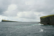 Southwards from the eastern edge of the Horse of Copinsay. Copinsay lighthouse is on the high ground in the distance.
Myths about the island include the story of the Copinsay Brownie.[6]
For many generations, prior to the final inhabitants moving to the Mainland in 1958, Copinsay was full of life; the large, double storey farm house and behind it the Steading (or farm buildings) form the farm tenants, a school with a school teacher and up to three lighthouse keepers' families.
There is also an ancient burial site on the island.
In the earlier part of the century a weekly postal service provided contact with the Mainland and fortnightly shopping trips to Deerness, allowing for weather. The farm boasted working horses, cattle and sheep - all of which had to be transported on the "coo" or "cow" boat. Birds' eggs provided a good supplement to the islanders diet, and men were lowered over the cliffs and a special rope, or rowed out to the Horse to bring back this addition.
Pigs were loosed in the spring on the Horse for many years - feeding on the bird eggs - transported across the sound by boat.
Many interesting facts and accounts of life on Copinsay are still retold in the Deerness Community, with many members still remembering when the island was still home to loved ones.
Ecology
The island was bought by the ornithology charity, the RSPB in 1972 in memory of the naturalist James Fisher.[7] Although Copinsay today is uninhabited, some fields are still farmed at the behest of the RSPB, to try provide suitable conditions for Corncrake, so the patch work of yesteryear is returning to the island, even though the people have not. Together with the three adjacent three islets (Corn Holm, Ward Holm and Black Holm), it is designated a Special Protection Area (SPA) under the European Union directive on the Conservation of Wild Birds due to the unimproved grassland vegetation and sheer sandstone cliffs providing ideal breeding ledges for seabirds.[8] There is a large colony of grey seals on the island. They usually pup in November each year. puffins can be seen during July on the adjacent holms.
Notable Residents
Edwin Muir, a famous poet
References
- ^ 2001 UK Census per List of islands of Scotland
- ^ Haswell-Smith, Hamish (2004). The Scottish Islands. Edinburgh: Canongate. ISBN 1841954543.
- ^ Ordnance Survey. Get-a-map (Map). http://www.ordnancesurvey.co.uk/oswebsite/getamap/.
- ^ Anderson, Joseph (Ed.) (1893) Orkneyinga Saga. Translated by Jón A. Hjaltalin & Gilbert Goudie. Edinburgh. James Thin and Mercat Press (1990 reprint). ISBN 0-901824-25-9
- ^ Pedersen, Roy (January 1992) Orkneyjar ok Katanes (map, Inverness, Nevis Print)
- ^ "Copinsay Brownie". http://www.orkneyjar.com/folklore/brownie.htm. Retrieved 2008-01-06.
- ^ "Copinsay reserve". RSPB. http://www.rspb.org.uk/reserves/guide/c/copinsay/index.asp.
- ^ "Copinsay SPA description". JNCC. http://www.jncc.gov.uk/default.aspx?page=1903.
South East Orkney Islands · Black Holm · Burray · Copinsay · Corn Holm · Glims Holm · Horse of Copinsay · Hunda · Lamb Holm · Pentland Skerries (Muckle Skerry) · South Ronaldsay · Swona ·
Orkney List of Orkney islands Inhabited Islands Mainland · Auskerry · Burray · Eday · Egilsay · Flotta · Gairsay · Graemsay · Hoy · North Ronaldsay · Papa Stronsay · Papa Westray · Rousay · Sanday · Shapinsay · South Ronaldsay · South Walls · Stronsay · Westray · WyreOther Islands Eynhallow · Helliar Holm · Lamb Holm · Switha · Swona · North West islands · North East islands · South West islands · South East islandsTowns and Villages Mainland Parishes Topics Categories:- Islands of the Orkney Islands
- Royal Society for the Protection of Birds reserves in Scotland
- Sites of Special Scientific Interest in Orkney
- Uninhabited islands of Orkney
- Former populated places in Scotland
- Protected areas of Orkney

Wikimedia Foundation. 2010.