- Moradabad district
-
This article is about the district. For its eponymous headquarters, see Moradabad.
Moradabad district
मोरादाबाद ज़िला
مراد آباد ضلع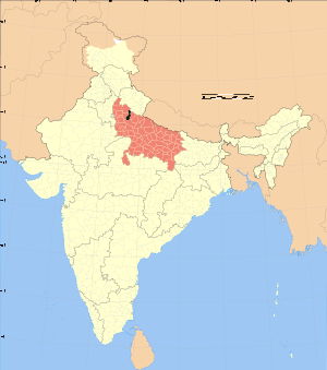
Location of Moradabad district in Uttar PradeshState Uttar Pradesh,  India
IndiaAdministrative division Moradabad Headquarters Moradabad Area 3,493 km2 (1,349 sq mi) Population 2,761,620 (2001) Literacy 45.74 per cent[1] Lok Sabha Constituencies Moradabad, Sambhal Official website Moradabad district (Hindi: मोरादाबाद ज़िला, Urdu: مراد آباد ضلع) is one of the districts of Uttar Pradesh state of India, and Moradabad town is the district headquarters. Moradabad district is a part of Moradabad division. As of 2011 it is the second most populous district of Uttar Pradesh (out of 71), after Allahabad.[2]
It was established in 1600 by Murad, the son of the Mughal Emperor Shahjahan; as a result the city came to known as Moradabad. It is the administrative headquarters of Moradabad District. Moradabad is situated at a distance of 167 km (104 mi) from the national capital, New Delhi, on the bank of River Ram Ganga (a tributary to the Ganges).
The district of Moradabad lies between 28°21´ to 28°16´ north latitude and 78°4´ to 79º east longitude. The district occupies an area of 3493 km2 and has a population of 61,620. The city is known for its export of brass handicrafts to North America and Europe, and is also thus called "Brass City" or Peetal Nagri. It has close to four million citizens of various ethnicities and religions.
Though an important agrarian market, Moradabad is known worldwide for brass works and glassware. Metalware, handicrafts, electroplating, sugar industry are the other industries.
Important landmarks include company Bagh, ancient Kali Mandir, Dum Duma Kothi. The city has more than 400 factories manufacturing brass, aluminum, iron and glass handicrafts. Many European and American companies including Wal-Mart, Carrefour, JC Penny, Target, Casto Rama, Home Depot andmore source merchandise from Moradabad.
Demographics
According to the 2011 census Moradabad district has a population of 4,773,138,[2] roughly equal to the nation of Singapore[3] or the US state of Alabama.[4] This gives it a ranking of 26th in India (out of a total of 640).[2] The district has a population density of 1,284 inhabitants per square kilometre (3,330 /sq mi) .[2] Its population growth rate over the decade 2001-2011 was 25.25 %.[2] Moradabad has a sex ratio of 903 females for every 1000 males,[2] and a literacy rate of 58.67 %.[2]
Minority population is about 46% of the total population of the district. Moradabad is a category "A" district i.e. having socio-economic and basic amenities parameters below the national average.[5]
External links
References
- ^ "District-specific Literates and Literacy Rates, 2001". Registrar General, India, Ministry of Home Affairs. http://www.educationforallinindia.com/page157.html. Retrieved 2010-10-10.
- ^ a b c d e f g "District Census 2011". Census2011.co.in. 2011. http://www.census2011.co.in/district.php. Retrieved 2011-09-30.
- ^ US Directorate of Intelligence. "Country Comparison:Population". https://www.cia.gov/library/publications/the-world-factbook/rankorder/2119rank.html. Retrieved 2011-10-01. "Singapore 4,740,737 July 2011 est."
- ^ "2010 Resident Population Data". U. S. Census Bureau. http://2010.census.gov/2010census/data/apportionment-pop-text.php. Retrieved 2011-09-30. "Alabama 4,779,736"
- ^ MINUTES OF THE 34th MEETING OF EMPOWERED COMMITTEE TO CONSIDER AND APPROVE REVISED PLAN FOR BALANCE FUND FOR THE DISTRICTS OF GHAZIABAD, BAREILLY, BARABANKI, SIDDHARTH NAGAR, SHAHJANPUR, MORADABAD, MUZAFFAR NAGAR, BAHRAICH AND LUCKNOW (UTTAR PRADESH) UNDER MULTI-SECTORAL DEVELOPMENT PROGRAMME IN MINORITY CONCENTRATION DISTRICTS HELD ON 22nd JULY, 2010 AT 11.00 A.M. UNDER THE CHAIRMANSHIP OF SECRETARY, MINISTRY OF MINORITY AFFAIRS. F. No. 3/64/2010-PP-I, GOVERNMENT OF INDIA, MINISTRY OF MINORITY AFFAIRS

Bijnor district Udham Singh Nagar district, Uttar Pradesh Jyotiba Phule Nagar district 
Rampur district  Moradabad district

Budaun district Divisions and Districts of Uttar Pradesh, India Agra division Aligarh division Aligarh · Etah · Mahamaya Nagar · Kanshi Ram Nagar
Allahabad division Azamgarh division Bareilly division Badaun · Bareilly · Pilibhit · Shahjahanpur
Basti division Chitrakoot division Banda · Chitrakoot · Hamirpur · Mahoba
Devipatan division Faizabad division Gorakhpur division Deoria · Gorakhpur · Kushinagar · Maharajganj
Jhansi division Kanpur division Auraiya · Etawah · Farrukhabad · Kannauj · Kanpur Nagar · Ramabai Nagar
Lucknow division Meerut division Bagpat · Bulandshahr · Gautam Buddha Nagar · Ghaziabad · Meerut · Panchsheel Nagar
Mirzapur division Moradabad division Bhimnagar · Bijnor · Jyotiba Phule Nagar · Moradabad · Rampur
Saharanpur division Prabuddhanagar · Muzaffarnagar · Saharanpur
Varanasi division Moradabad division topics General Districts Rivers, dams, lakes Ganges • RamgangaLanguages, people Transport Lok Sabha constituencies See also Cities and towns in Bhimnagar district • Cities and towns in Bijnor district • Cities and towns in Jyotiba Phule Nagar district • Cities and towns in Moradabad district • Cities and towns in Rampur district • Villages in Bhimnagar District • Villages in Bijnor district • Villages in Jyotiba Phule Nagar district • Villages in Moradabad district • People from Jyotiba Phule Nagar • People from Bijnor • People from Moradabad • People from RampurOther Divisions Agra • Aligarh • Allahabad • Azamgarh • Bareilly • Basti • Chitrakoot • Devipatan • Faizabad • Gorakhpur • Jhansi • Kanpur • Lucknow • Meerut • Mirzapur • Saharanpur • VaranasiMinority Concentrated Districts in India Andaman & Nicobar Islands Arunachal Pradesh Assam Barpeta · Bongaigaon · Cachar · Darrang · Dima Hasao · Dhubri · Goalpara · Hailakandi · Kamrup · Karimganj · Kokrajhar · Marigaon · Nagaon
Bihar Delhi Haryana Jammu & Kashmir Jharkhand Karnataka Kerala Madhya Pradesh Maharashtra Manipur Meghalaya Mizoram Orissa Uttar Pradesh Baghpat · Bahraich · Balrampur · Barabanki · Bareilly · Bijnor · Budaun · Bulandshahar · Ghaziabad · Jyotiba Phule Nagar · Kheri · Lucknow · Meerut · Moradabad · Muzaffarnagar · Pilibhit · Rampur · Saharanpur · Shahjahanpur · Shravasti · Siddharth NagarUttarakhand West Bengal Bardhaman · Birbhum · Cooch Behar · Dakshin Dinajpur · Howrah · Kolkata · Malda · Murshidabad · Nadia · North 24 Parganas · South 24 Parganas · Uttar DinajpurCategories:

Wikimedia Foundation. 2010.