- Oklahoma State Highway 24
-
State Highway 24
Route information Maintained by ODOT Length: 21.3 mi (34.3 km) Existed: 1936/37 [1] – present Major junctions South end:  SH-74 north of Maysville
North end: SH-74 north of WashingtonHighway system Oklahoma State Highways
Oklahoma turnpike system←  SH-23
SH-23SH-25  →
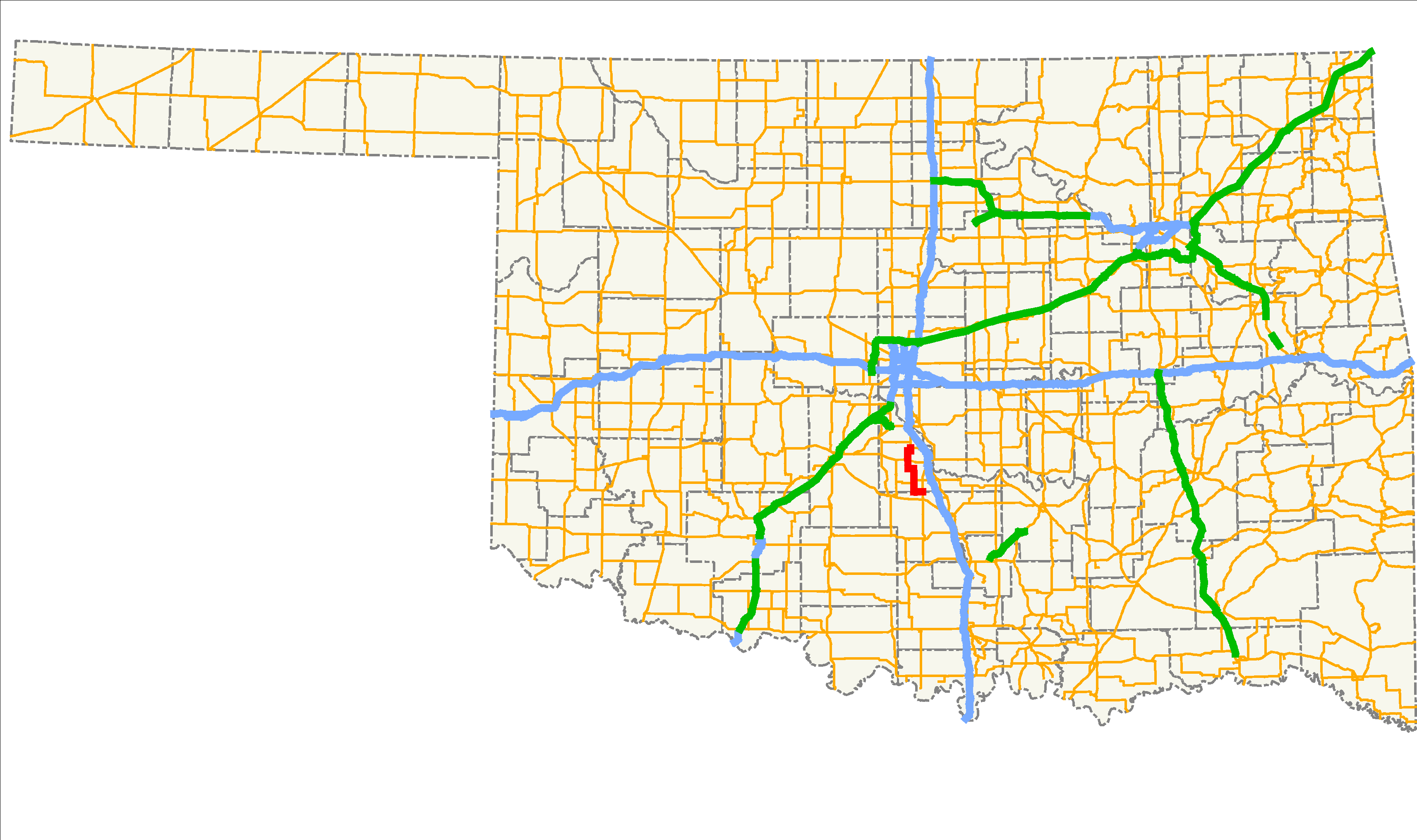
→State Highway 24, also sometimes referred to as Highway 24, SH-24, or OK-24, is a highway maintained by the U.S. state of Oklahoma. It runs for 21.3 miles[2] (34.1 km) through central Oklahoma, entirely within McClain County. It is signed north–south and has no lettered spur routes.
SH-24 was designated in 1936, and originally extended southward into Garvin County to an intersection with SH-19 between Maysville and Lindsay. By 1950, its southern terminus had been moved to its current location, while a new bridge near Washington caused a realignment of the highway in the early 1990s.
Contents
Route description
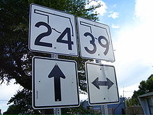 SH-24 southbound approaching SH-39 in Woody Chapel
The highway begins where State Highway 74 crosses the McClain–Garvin County line, about three miles (5 km) north of Maysville.[3] From here, SH-24 runs west along the county line for three miles (5 km), where it turns due north in the unincorporated community of Storey.[4] It has a brief, 1-mile (1.6 km) concurrency with SH-59 east of Payne.[2] After this, the road turns west again and returns to a due north course before intersecting SH-39 in the unincorporated town of Woody Chapel.[4]
From Woody Chapel, Highway 24 continues northward (encountering a few curves to avoid a small pond)[4] to the town of Washington. Through Washington, the road runs east–west and is named Morehead Street. After passing through Washington, SH-24 turns back northward, crossing Walnut Creek just after the turn. At the southern limit of the town of Goldsby, the road meets SH-74 again. At this intersection, the mainline road becomes SH-74 northbound, turning right is SH-74 southbound, and turning left puts you on the old SH-24 alignment through Washington.
History
SH-24 first appeared on the 1937 State Highway map,[1] meaning it was first designated sometime between May 1936 and April 1937. The original route continues south from where the highway now turns to run along the McClain–Garvin county line, ending at SH-19 between Maysville and Lindsay. This routing was shown on the 1948 map[5], while the current southern terminus was first shown on the 1950 map,[6] suggesting the change was made sometime between 1948 and 1950.
From the highway's creation to the early 1990s, the road ran north along Main Street through downtown Washington, crossing over Walnut Creek via an old, one-lane truss bridge, built in 1927.[7] However, a new bridge to the east of town was built in 1993,[8] and SH-24 routed over it. The old bridge still serves as an alternate route out of Washington; the old SH-24 alignment has been designated "Walnut Creek Road" by McClain County.
Junction list
County Location Mile[2] Destinations Notes McClain 0.0 SH-74Southern terminus 6.1  SH-59
SH-59Southern end of SH-59 concurrency 7.1 SH-59Northern end of SH-59 concurrency Woody Chapel 16.1  SH-39
SH-39Goldsby 21.3 SH-74Northern terminus 1.000 mi = 1.609 km; 1.000 km = 0.621 mi
Concurrency terminus • Closed/Former • Incomplete access • UnopenedReferences
- ^ a b Oklahoma Department of Highways (1937). Map Showing Condition of Improvement of the State Highway System and Landing Fields (Map). http://www.odot.org/hqdiv/p-r-div/maps/state-maps/pdfs/1937.pdf. Retrieved 2007-10-14.
- ^ a b c Stuve, Eric. "OK-24". OKHighways. http://www.okhighways.com/ok24.html. Retrieved 2007-06-23.
- ^ Oklahoma Department of Transportation. Official State Map (Map) (2009–10 ed.). http://www.odot.org/hqdiv/p-r-div/maps/state-maps/2009state/pdfs/state-map.pdf. Retrieved 2010-08-18.
- ^ a b c DeLorme (2006). Oklahoma Atlas and Gazetteer (Map). 1:200,000.
- ^ Oklahoma Department of Highways. Map of Oklahoma's State Highway System (Map). Cartography by Gorand Maps (1948 ed.). http://www.okladot.state.ok.us/hqdiv/p-r-div/maps/state-maps/pdfs/1948.pdf.
- ^ Oklahoma Department of Highways. Map of Oklahoma's State Highway System (Map) (1950 ed.). http://www.okladot.state.ok.us/hqdiv/p-r-div/maps/state-maps/pdfs/1950.pdf.
- ^ Plaque on bridge's northern portal.
- ^ National Bridge Inventory, bridge 231320000000000
External links
Categories:- State highways in Oklahoma
- McClain County, Oklahoma


Wikimedia Foundation. 2010.