- Geography of Aruba
-
Aruba Nickname: One Happy Island 
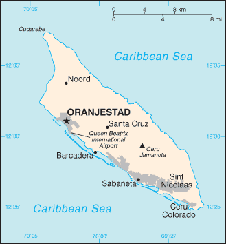
Map of Aruba
Geography Location Caribbean Sea Coordinates 12°30′N 69°58′W / 12.5°N 69.967°W Archipelago ABC islands (Lesser Antilles) Area 139 km2 (53.7 sq mi) Coastline 68.5 km (42.56 mi) Highest elevation 188 m (617 ft) Highest point Mount Jamanota Country ArubaLargest city Oranjestad (pop. 32,748) Demographics Population 104,494 (as of 2007) Density 751.76 /km2 (1,947.05 /sq mi) Ethnic groups Mixed Caribbean Amerindian and white  NASA satellite image of Aruba.
 Casibari Rock Formation
 Aruba's natural landbridge in 2005, before its subsequent collapse due to coastal erosion.
Aruba is a small Caribbean island (54 sq mi/140 km2) about the size of Washington, D.C., located 25 km north of the coast of Venezuela and 68 km northwest of Curaçao, the largest island of the Kingdom of the Netherlands. Aruba’s terrain is mostly flat with a few hills. There is little in the way of vegetation or outstanding physical features and no inland water. Aruba’s best-known geographical feature is its white-sand beaches, which are the basis of an active tourism industry that is the mainstay of the island’s economy. Aruba is situated on the Caribbean Tectonic Plate. The island is made up of limestone-capped hills and ridges, with cliffs on the northern and northeastern coasts and coral reefs on the southern coast.
Contents
Mountains and Hills
Aruba’s terrain is almost entirely flat. The highest elevation, so-called Mount Jamanota, is only 188 m above sea level. Rock formations characterize the interior of the island.
The Coast and Beaches
Aruba has three deepwater harbors located at Oranjestad, Barcadera, and San Nicolaas (Sint Nicolaas). The coastal area is known for its white-sand beaches and the calm waters surrounding Aruba are clear, making it a popular tourist destination.
Climate
Temperature
Aruba’s tropical marine climate varies little seasonally, with an average annual temperature of 27 °C (80.6 °F), varying from about 26 °C (78.8 °F) in January to 29 °C (84.2 °F) in July.
Rainfall
Most rain brought by the prevailing easterly winds of the region falls on the Windward Islands of the Lesser Antilles, leaving Aruba with a very dry climate. Rainfall averages 510 mm (20.1 in) or less annually, and the island’s residents rely on one of the world’s largest desalination plants for most of their drinking water. The rainy season occurs between October and December.
Statistics
- Location
- Caribbean, island in the Caribbean Sea, north of Venezuela
- Geographic coordinates
- 12°30′N 69°58′W / 12.5°N 69.967°WCoordinates: 12°30′N 69°58′W / 12.5°N 69.967°W
- Map references
- Central America and the Caribbean
- Area
-
- Total: 193 km²
- Land: 193 km²
- Water: 0 km²
country comparison to the world: 108
- Area comparative
- slightly larger than Washington DC
- Land boundaries
- 0 km
- Coastline
- 68.5 km
- Maritime claims
The "Rijkswet" of December 12, 1985, for the maritime boundaries between The Netherlands Antilles and Aruba, and the Maritime Boundaries Treaty signed March 31, 1978, between the Republic of Venezuela and the Kingdom of the Netherlands, introduced December 12, 1978, and valid for Aruba since January 1, 1986.
- Territorial sea: 12 nmi (22.2 km; 13.8 mi)
- Climate
- Tropical marine; little seasonal temperature variation
- Terrain
- Flat with a few hills; scant vegetation
- Elevation extremes
-
- Lowest point: Caribbean Sea 0 m
- Highest point: Mount Jamanota 188 m
- Best known: Hooiberg 165 m (541 ft)
- Natural resources
- Negligible; white sandy beaches
- Land use
-
- Arable land: 10.53% (including aloe 0.01%)
- Permanent crops: 0%
- Other: 89.47% (2005)
- Irrigated land
- 0.01 km² (1998 est.)
- Natural hazards
- While Aruba barely lies within the Caribbean hurricane belt, storms rarely if ever pass over the island.
- Environment--current issues
- NA
- Geography-note
- A flat, riverless island renowned for its white sand beaches; its tropical climate is moderated by constant trade winds from the Atlantic Ocean; the temperature is almost constant at about 27 degrees Celsius.
See also
External links
- Map of ArubaPDF
- Map of Aruba
- Maps of Aruba (including island map, and detail maps of Oranjestad and San Nicolas)
Aruba topics Politics and government Coast guard · Coat of arms · Constitution · Elections · Estates (parliament) · Flag · Foreign relations · Governor · Military · Monarch · Police · Political parties · Prime Minister · Visa policyCulture and history Economy and infrastructure Geography and environment Sports See also: Index of Aruba-related articles, Outline of Aruba, Kingdom of the Netherlands, Netherlands Antilles Sovereign states Antigua and Barbuda · Bahamas · Barbados · Belize · Canada · Costa Rica · Cuba · Dominica · Dominican Republic · El Salvador · Grenada · Guatemala · Haiti · Honduras · Jamaica · Mexico · Nicaragua · Panama · Saint Kitts and Nevis · Saint Lucia · Saint Vincent and the Grenadines · Trinidad and Tobago · United States
Dependencies and
other territoriesAnguilla · Aruba · Bermuda · Bonaire · British Virgin Islands · Cayman Islands · Curaçao · Greenland · Guadeloupe · Martinique · Montserrat · Navassa Island · Puerto Rico · Saint Barthélemy · Saint Martin · Saint Pierre and Miquelon · Saba · Sint Eustatius · Sint Maarten · Turks and Caicos Islands · United States Virgin Islands
Sovereign states Dependencies and
other territories- Aruba
- Bonaire
- Curaçao
- Falkland Islands
- French Guiana
- South Georgia and the South Sandwich Islands
Climate of South America Sovereign states Dependencies and
other territories- Aruba
- Bonaire
- Curaçao
- Falkland Islands
- French Guiana
- South Georgia and the South Sandwich Islands
Categories:


Wikimedia Foundation. 2010.