- National Register of Historic Places listings in Kenai Peninsula Borough, Alaska
-
 Location of the Kenai Peninsula Borough in Alaska
This is a list of the National Register of Historic Places listings in Kenai Peninsula Borough, Alaska.
This is intended to be a complete list of the properties and districts on the National Register of Historic Places in Kenai Peninsula Borough, Alaska, United States. The locations of National Register properties and districts for which the latitude and longitude coordinates are included below, may be seen in a Google map.[1]
There are 33 properties and districts listed on the National Register in the borough, including two National Historic Landmarks.
-
- This National Park Service list is complete through NPS recent listings posted November 10, 2011.[2]
Current listings
[3] Landmark name[4] Image Date listed Location Community Summary 1 Alaska Central Railroad: Tunnel No. 1 November 28, 1977 North of Seward
60°39′17″N 149°3′20″W / 60.65472°N 149.05556°WSeward 2 Alaska Nellie's Homestead April 3, 1975 Mile 23 on the Seward Highway
60°24′5″N 149°21′32″W / 60.40139°N 149.35889°WLawing 3 Ballaine House July 12, 1978 437 3rd Ave.
60°6′25″N 149°26′25″W / 60.10694°N 149.44028°WSeward 4 Andrew Berg Cabin 
April 21, 2000 30 miles southeast of Soldotna
60°7′3″N 150°37′40″W / 60.1175°N 150.62778°WSoldotna 5 Brown & Hawkins Store June 23, 1988 205, 207, and 209 4th Ave.
60°06′05″N 149°26′26″W / 60.10139°N 149.44056°WSeward 6 Chugachik Island Site August 19, 1976 Address Restricted Homer 7 Church of the Assumption of the Virgin Mary 
May 10, 1970 Mission and Overland Sts.
60°33′10.7″N 151°16′03.4″W / 60.552972°N 151.267611°WKenai 8 Coal Village Site November 21, 1978 North of Port Graham
59°23′52″N 151°53′52″W / 59.39778°N 151.89778°WPort Graham 9 Cooper Landing Historic District August 21, 1986 Alaska Route 1
60°29′21″N 149°49′57″W / 60.48917°N 149.8325°WCooper Landing 10 Cooper Landing Post Office May 23, 1978 Sterling Highway
60°29′25″N 149°49′57″W / 60.49028°N 149.8325°WCooper Landing 11 Diversion Tunnel November 23, 1977 At Lowell Creek
60°6′14″N 149°27′9″W / 60.10389°N 149.4525°WSeward 12 Government Cable Office 
January 4, 1980 218 6th Ave.
60°6′15″N 149°26′8″W / 60.10417°N 149.43556°WSeward 13 Hirshey Mine September 13, 1978 Southeast of Hope on Palmer Creek Rd.
60°47′39″N 149°31′5″W / 60.79417°N 149.51806°WHope 14 Hoben Park June 21, 2006 401 Railway Ave.
60°5′39″N 149°26′19″W / 60.09417°N 149.43861°WSeward 15 Victor Holm Cabin April 13, 1977 Southwest of Kenai on Cohoe Rd. at the Kasilof River Kenai 16 Victor Holm Homestead January 17, 2006 Address Restricted Kasilof 17 Holy Transfiguration of Our Lord Chapel 
May 22, 1978 Sterling Highway
60°3′3″N 151°39′46″W / 60.05083°N 151.66278°WNinilchik 18 Hope Historic District April 25, 1972 Mile 17 on Hope Rd.
60°55′11″N 149°38′22″W / 60.91972°N 149.63944°WHope 19 Harry A. Johnson Trapline Cabin May 5, 2000 20 miles south of Hope
60°45′21″N 149°56′39″W / 60.75583°N 149.94417°WHope 20 Lauritsen Cabin October 16, 1979 North of Moose Pass off Alaska Route 1
60°40′23″N 149°28′19″W / 60.67306°N 149.47194°WMoose Pass 21 Jesse Lee Home for Children September 29, 1995 Swetmann Avenue
60°07′35″N 149°26′48″W / 60.12639°N 149.44667°WSeward 22 Moose River Site December 20, 1978 Address Restricted Sterling 23 St. Nicholas Chapel 
June 6, 1980 In Seldovia
59°25′49″N 151°42′40″W / 59.43028°N 151.71111°WSeldovia 24 St. Peter's Episcopal Church 
December 21, 1979 2nd Ave. and Adams St.
60°6′7″N 149°26′41″W / 60.10194°N 149.44472°WSeward 25 Sts. Sergius and Herman of Valaam Church June 6, 1980 In English Bay English Bay 26 Selenie Lagoon Archeological Site October 16, 1974 Address Restricted Port Graham 27 Seward Depot July 16, 1987 501 Railway Ave.
60°5′39″N 149°26′19″W / 60.09417°N 149.43861°WSeward 28 Soldotna Post Office September 17, 2008 Corner of E. Corral St. and the Kenai Spur Highway
60°29′35.196″N 151°4′0.552″W / 60.49311°N 151.06682°WSoldotna 29 Sunrise City Historic District August 19, 1997 At the mouth of Sixmile Creek, east of Hope
60°53′23″N 149°25′16″W / 60.88972°N 149.42111°W[5]Hope 30 Swetman House February 17, 1978 325 5th Ave.
60°6′15″N 149°26′14″W / 60.10417°N 149.43722°WSeward 31 Thorn-Stingley House February 2, 2001 1660 East End Road
59°39′21″N 151°30′11″W / 59.65583°N 151.50306°WHomer 32 Van Gilder Hotel 
December 2, 1980 307 Adams Street
60°06′11″N 149°26′27″W / 60.10306°N 149.44083°WSeward 33 Yukon Island Main Site 
October 15, 1966 Yukon Island, 9 miles south of Homer
59°31′22.5″N 151°29′55.5″W / 59.522917°N 151.49875°W[6]Homer See also
- List of National Historic Landmarks in Alaska
- National Register of Historic Places listings in Alaska
References
- ^ The latitude and longitude information provided in this table was derived originally from the National Register Information System, which has been found to be fairly accurate for about 99% of listings. For about 1% of NRIS original coordinates, experience has shown that one or both coordinates are typos or otherwise extremely far off; some corrections may have been made. A more subtle problem causes many locations to be off by up to 150 yards, depending on location in the country: most NRIS coordinates were derived from tracing out latitude and longitudes off of USGS topographical quadrant maps created under North American Datum of 1927, which differs from the current, highly accurate GPS system used by Google maps. Chicago is about right, but NRIS longitudes in Washington are higher by about 4.5 seconds, and are lower by about 2.0 seconds in Maine. Latitudes differ by about 1.0 second in Florida. Some locations in this table may have been corrected to current GPS standards.
- ^ "National Register of Historic Places: Weekly List Actions". National Park Service, United States Department of the Interior. Retrieved on November 10, 2011.
- ^ Numbers represent an ordering by significant words. Various colorings, defined here, differentiate National Historic Landmark sites and National Register of Historic Places Districts from other NRHP buildings, structures, sites or objects.
- ^ "National Register Information System". National Register of Historic Places. National Park Service. 2008-04-24. http://nrhp.focus.nps.gov/natreg/docs/All_Data.html.
- ^ Location derived from its GNIS feature record; the NRIS lists the site as "Address Restricted"
- ^ Location (derived from the GNIS) is for the small island on which the site is located; the NRIS lists the site as "Address Restricted"
U.S. National Register of Historic Places Topics Lists by states Alabama • Alaska • Arizona • Arkansas • California • Colorado • Connecticut • Delaware • Florida • Georgia • Hawaii • Idaho • Illinois • Indiana • Iowa • Kansas • Kentucky • Louisiana • Maine • Maryland • Massachusetts • Michigan • Minnesota • Mississippi • Missouri • Montana • Nebraska • Nevada • New Hampshire • New Jersey • New Mexico • New York • North Carolina • North Dakota • Ohio • Oklahoma • Oregon • Pennsylvania • Rhode Island • South Carolina • South Dakota • Tennessee • Texas • Utah • Vermont • Virginia • Washington • West Virginia • Wisconsin • WyomingLists by territories Lists by associated states Other Properties on the National Register of Historic Places in Alaska  Boroughs
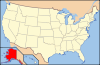 Aleutians East • Anchorage • Bristol Bay • Denali • Fairbanks North Star • Haines • Juneau • Kenai Peninsula • Ketchikan Gateway • Kodiak Island • Lake and Peninsula • Matanuska-Susitna • North Slope • Northwest Arctic • Sitka • Skagway • Wrangell • YakutatCensus areasAleutians West • Bethel • Dillingham • Hoonah-Angoon • Nome • Petersburg • Prince of Wales-Hyder • Southeast Fairbanks • Valdez-Cordova • Yukon-KoyukukThere are no sites listed on the National Register of Historic Places in Wade Hampton Census Area
Municipalities and communities of Kenai Peninsula Borough, Alaska Cities 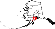
CDPs Anchor Point | Bear Creek | Beluga | Clam Gulch | Cohoe | Cooper Landing | Crown Point | Diamond Ridge | Fox River | Fritz Creek | Funny River | Halibut Cove | Happy Valley | Hope | Kalifornsky | Kasilof | Lowell Point | Miller Landing | Moose Pass | Nanwalek | Nikiski | Nikolaevsk | Ninilchik | Port Graham | Primrose | Ridgeway | Salamatof | Seldovia Village | Sterling | Sunrise | Tyonek
Unincorporated
communitiesKachemak Selo | Razdolna | Voznesenka
Categories:- National Register of Historic Places in Alaska by borough and census area
- Kenai Peninsula Borough, Alaska
-


Wikimedia Foundation. 2010.