- National Register of Historic Places listings in Bayfield County, Wisconsin
-
Buildings, sites, districts, and objects in Bayfield County listed on the National Register of Historic Places
-
- This National Park Service list is complete through NPS recent listings posted November 10, 2011.[1]
This document is intended to provide a comprehensive listing of entries in the National Register of Historic Places that are located in Bayfield County, Wisconsin. The locations of National Register properties, the latitude and longitude coordinates of which are included below, may be seen in a Google map.[2]
[3] Landmark name [4] Image Date listed Location City or town Summary 1 Apostle Islands Lighthouses 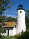
March 8, 1977 N and E of Bayfield on Michigan, Raspberry, Outer, Sand and Devils Islands
46°59′38″N 90°36′06″W / 46.993889°N 90.601667°WBayfield 2 Bank of Washburn January 17, 1980 Bayfield St. and Central Ave.
46°40′24″N 90°53′29″W / 46.673333°N 90.891389°WWashburn 3 Bayfield County Courthouse January 17, 1975 117 E. 5th St.
46°40′37″N 90°53′33″W / 46.676944°N 90.8925°WWashburn 4 Bayfield Fish Hatchery July 22, 1981 WI 13
46°47′10″N 90°51′49″W / 46.786111°N 90.863611°WSalmo 5 Bayfield Historic District November 25, 1980 WI J and WI 13
46°48′43″N 90°49′07″W / 46.811944°N 90.818611°WBayfield 6 Booth Cooperage August 13, 1976 1 East Washington St.
46°48′45″N 90°48′45″W / 46.8125°N 90.8125°WBayfield 7 Frank Boutin, Jr. House December 27, 1974 7 Rice St.
46°48′50″N 90°48′49″W / 46.813889°N 90.813611°WBayfield 8 Christ Episcopal Church December 27, 1974 121-125 North 3rd. St.
46°48′46″N 90°49′07″W / 46.812778°N 90.818611°WBayfield 9 Forest Lodge February 14, 2002 Garmisch Rd.
46°12′17″N 91°06′32″W / 46.204722°N 91.108889°WNamakagon 10 Forest Lodge Library July 11, 2001 13450 Cty Hwy M
46°12′28″N 91°17′29″W / 46.207778°N 91.291389°WCable 11 Herbster Community Center August 15, 1997 Lenawee Rd., S of jct. of Lenawee Rd. and WI 13
46°49′51″N 91°15′43″W / 46.830833°N 91.261944°WHerbster 12 Hokenson Fishing Dock June 18, 1976 N of Bayfield at Little Sand Bay
46°56′48″N 90°53′29″W / 46.946667°N 90.891389°WBayfield 13 Island Lake Camp March 12, 1982 Island Lake Rd.
46°23′11″N 91°31′50″W / 46.386389°N 91.530556°WDrummond 14 Old Bayfield County Courthouse December 27, 1974 Washington St. between 4th and 5th Sts.
46°48′47″N 90°49′13″W / 46.813056°N 90.820278°WBayfield 15 OTTAWA (Tug) Shipwreck Site June 8, 1992 Address Restricted
46°53′08″N 90°45′39″W / 46.885556°N 90.760833°WRussell (see/include link to [1]) 16 John and Justina Palo Homestead September 12, 2002 71055 Muskeg Rd.
46°36′19″N 91°28′12″W / 46.605278°N 91.47°WOulu 17 Pureair Sanatorium August 20, 1981 S of Bayfield
46°47′27″N 90°50′50″W / 46.790833°N 90.847222°WBayfield 18 SEVONA (Bulk Carrier) Shipwreck Site April 9, 1993 Address Restricted Bayfield (see/include link to [2]) 19 Sevona Cabin September 29, 1976 N of Bayfield on Sand Island
46°57′49″N 90°56′14″W / 46.963611°N 90.937222°WBayfield 20 Shaw Farm June 18, 1976 Sand Island
46°57′47″N 90°56′03″W / 46.963056°N 90.934167°WBayfield 21 Washburn Public Library March 1, 1984 Washington Ave. and W. 3rd St.
46°40′22″N 90°53′43″W / 46.672778°N 90.895278°WWashburn See also
References
- ^ "National Register of Historic Places: Weekly List Actions". National Park Service, United States Department of the Interior. Retrieved on November 10, 2011.
- ^ The latitude and longitude information provided is primarily from the National Register Information System, and has been found to be fairly accurate for about 99% of listings. For 1%, the location info may be way off. We seek to correct the coordinate information wherever it is found to be erroneous. Please leave a note in the Discussion page for this article if you believe any specific location is incorrect.
- ^ Numbers represent an ordering by significant words. Various colorings, defined here, differentiate National Historic Landmark sites and National Register of Historic Places Districts from other NRHP buildings, structures, sites or objects.
- ^ "National Register Information System". National Register of Historic Places. National Park Service. . http://nrhp.focus.nps.gov/natreg/docs/All_Data.html.
U.S. National Register of Historic Places Topics Lists by states Alabama • Alaska • Arizona • Arkansas • California • Colorado • Connecticut • Delaware • Florida • Georgia • Hawaii • Idaho • Illinois • Indiana • Iowa • Kansas • Kentucky • Louisiana • Maine • Maryland • Massachusetts • Michigan • Minnesota • Mississippi • Missouri • Montana • Nebraska • Nevada • New Hampshire • New Jersey • New Mexico • New York • North Carolina • North Dakota • Ohio • Oklahoma • Oregon • Pennsylvania • Rhode Island • South Carolina • South Dakota • Tennessee • Texas • Utah • Vermont • Virginia • Washington • West Virginia • Wisconsin • WyomingLists by territories Lists by associated states Other Municipalities and communities of Bayfield County, Wisconsin Cities 
Village Towns CDPs Cable | Cornucopia | Drummond | Grand View | Herbster | Iron River | Port Wing
Unincorporated
communitiesFootnotes ‡This populated place also has portions in an adjacent county or counties
Categories:- Bayfield County, Wisconsin
- Lists of historic places in Wisconsin
-


Wikimedia Foundation. 2010.