- National Register of Historic Places listings in East and Northeast Baltimore
-
National Register of Historic Places listings in the city of Baltimore, Maryland
The locations of the National Register properties and districts listed below (at least for all showing latitude and longitude coordinates below) may be seen in a Google map by clicking on "Map of all coordinates".[1]
This list covers some of the properties in the independent city of Baltimore, but not those in the county of Baltimore surrounding the city. The county actually does not include the city; the city is an independent county-equivalent.
-
- This National Park Service list is complete through NPS recent listings posted November 10, 2011.[2]
Main:List of RHPs in Baltimore
Current listings
[3] Landmark name Image Date listed Location District[4] Summary 1 American Brewery 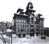
May 9, 1973 1701 N. Gay St.
39°18′34″N 76°35′06″W / 39.309444°N 76.585°WEast 2 Arcadia-Beverly Hills Historic District 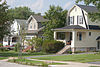
December 23, 2004 Moravia Rd.-Belair Rd.-Herring Run Park-Harford Rd.
39°20′13″N 76°34′06″W / 39.336944°N 76.568333°WNortheast 3 Baltimore City College 
June 30, 2003 3320 The Alameda
39°19′17″N 76°35′46″W / 39.321389°N 76.596111°WNortheast 4 Baltimore East/South Clifton Park Historic District December 27, 2002 Roughly bounded by Clifton Park, N. Broadway, E. Chase St., and N. Rose St.
39°18′33″N 76°35′22″W / 39.309167°N 76.589444°WEast 5 Bohemian National Cemetery November 10, 2010 1300 Horners Lane
39°18′28″N 76°33′13″W / 39.307778°N 76.553611°WEast 6 Clifton Park Valve House 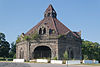
February 18, 1971 2801 Harford Rd.
39°19′09″N 76°35′13″W / 39.319167°N 76.586944°WNortheast 7 Clifton School 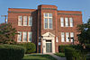
December 16, 1982 2670 Kennedy Ave.
39°19′18″N 76°35′46″W / 39.321667°N 76.596111°WNortheast 8 East Monument Historic District December 8, 2009 N. Washington St. on the west, an Amtrak rail line on the north to East St., south to Monument, and east to Highland Ave.
39°18′02″N 76°34′48″W / 39.300544°N 76.579944°WNortheast 9 Engine House No. 6 June 18, 1973 416 N. Gay St.
39°17′43″N 76°36′20″W / 39.295278°N 76.605556°WEast 10 Friends Burial Ground January 12, 2005 2506 Harford Rd.
39°19′05″N 76°35′42″W / 39.318056°N 76.595°WNortheast 11 Green Mount Cemetery 
April 2, 1980 Bounded by North and Greenmount Aves. and Ensor and Hoffman Sts.
39°18′31″N 76°36′24″W / 39.308611°N 76.606667°WEast 12 Gompers School June 20, 1985 1701 E. North Ave.
39°18′43″N 76°35′41″W / 39.311944°N 76.594722°WEast 13 L. Grief and Bro., Inc. Manufactory December 19, 2007 901 N. Milton Ave.
39°18′05″N 76°34′57″W / 39.301389°N 76.5825°WEast 14 Industrial Building March 10, 1980 501 E. Preston St.
39°18′16″N 76°36′31″W / 39.304444°N 76.608611°WEast 15 Lauraville Historic District 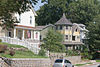
December 28, 2001 Roughly bounded by Harford Rd., Herring Run Creek, Cold Spring Ln., Charlton Ave., Halcyon Ave., Grindon Rd., and Echodale Ave.
39°20′44″N 76°34′23″W / 39.345556°N 76.573056°WNortheast 16 Mayfield Historic District 
January 6, 2004 Lake Montebello Rd.-Chesterfield Ave.,-Crossland Ave.-Erdman Ave.
39°19′49″N 76°34′48″W / 39.330278°N 76.58°WNortheast 17 North Central Historic District December 27, 2002 Roughly bounded by North Ave., Greenmount Ave., Falls Rd., and Interstate 83
39°18′34″N 76°36′48″W / 39.309444°N 76.613333°WEast 18 Null House January 27, 1983 1037 Hillen St.
39°17′46″N 76°36′22″W / 39.296111°N 76.606111°WEast 19 Old East Baltimore Historic District December 27, 2006 Generally bounded by Jones Falls, Greenmount Cemetery, North Ave., Broadway, and Madison, Ashland and Eager Sts.
39°18′19″N 76°36′16″W / 39.305278°N 76.604444°WEast 20 Old Town Savings Bank May 9, 1996 353 N. Gay St.
39°17′40″N 76°36′24″W / 39.294444°N 76.606667°WEast 21 Public School No. 37 September 25, 1979 E. Biddle St. and N. Patterson Park Ave.
39°18′16″N 76°35′08″W / 39.304444°N 76.585556°WEast 22 Public School No. 99 September 25, 1979 E. North Ave. and N. Washington St.
39°18′46″N 76°35′25″W / 39.312778°N 76.590278°WEast 23 Public School No. 109 September 25, 1979 N. Broadway and Ashland Ave.
39°18′01″N 76°35′39″W / 39.300278°N 76.594167°WEast 24 Rowhouses at 303-327 East North Avenue September 13, 1984 303-327 E. North Ave.
39°18′40″N 76°36′43″W / 39.311111°N 76.611944°WEast 25 St. James the Less Roman Catholic Church March 15, 1982 Aisquith St. at Eager St.
39°18′04″N 76°36′08″W / 39.301111°N 76.602222°WEast 26 St. John the Evangelist Roman Catholic Church March 15, 1982 901 E. Eager St.
39°18′05″N 76°36′17″W / 39.301389°N 76.604722°WEast 27 Hans Schuler Studio and Residence 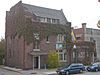
September 27, 1985 5 East Lafayette Ave.
39°18′34″N 76°36′57″W / 39.309583°N 76.615833°WEast 28 Sydenham Hospital for Communicable Diseases 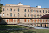
October 30, 1998 Argonne Dr., west of Herring Rd.
39°20′16″N 76°34′52″W / 39.337778°N 76.581111°WNortheast 29 Taylor's Chapel 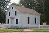
July 28, 1983 6001 Hillen Rd., Mount Pleasant Park
39°21′46″N 76°34′40″W / 39.362778°N 76.577778°WNortheast See also
References
- ^ The latitude and longitude information provided in this table was derived originally from the National Register Information System, which has been found to be fairly accurate for about 99% of listings. For about 1% of NRIS original coordinates, experience has shown that one or both coordinates are typos or otherwise extremely far off; some corrections may have been made. A more subtle problem causes many locations to be off by up to 150 yards, depending on location in the country: most NRIS coordinates were derived from tracing out latitude and longitudes off of USGS topographical quadrant maps created under the North American Datum of 1927, which differs from the current, highly accurate WGS84 GPS system used by Google maps. Chicago is about right, but NRIS longitudes in Washington are higher by about 4.5 seconds, and are lower by about 2.0 seconds in Maine. Latitudes differ by about 1.0 second in Florida. Some locations in this table may have been corrected to current GPS standards.
- ^ "National Register of Historic Places: Weekly List Actions". National Park Service, United States Department of the Interior. Retrieved on November 10, 2011.
- ^ Numbers represent an ordering by significant words. Various colorings, defined here, differentiate National Historic Landmark sites and National Register of Historic Places Districts from other NRHP buildings, structures, sites or objects.
- ^ Official Baltimore neighborhoods, defined here
U.S. National Register of Historic Places in Maryland Lists by county Allegany • Anne Arundel • Baltimore County • Calvert • Caroline • Carroll • Cecil • Charles • Dorchester • Frederick • Garrett • Harford • Howard • Kent • Montgomery • Prince George's • Queen Anne's • Somerset • St. Mary's • Talbot • Washington • Wicomico • Worcester
Lists by city Baltimore: (Central · North and Northwest · West and Southwest · East and Northeast · South and Southeast)Other lists Categories:- National Register of Historic Places in Maryland by county
- History of Baltimore, Maryland
-


Wikimedia Foundation. 2010.