- Meiße
-
Meiße 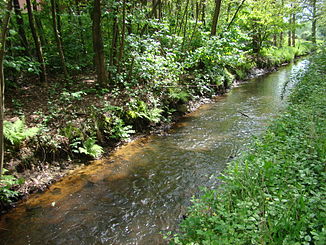
The Meiße near Bleckmar
Data Location Lower Saxony,  Germany
Length 42 km Source South of Wietzendorf in the Großes Moor near Becklingen nature reserve
52°51′30″N 9°57′39″E / 52.85833°N 09.96083°ECoordinates: 52°51′30″N 9°57′39″E / 52.85833°N 09.96083°ESource height 73 m above sea level Mouth South of Hodenhagen
52°45′34″N 9°34′59″E / 52.75944°N 9.58306°EMouth height 21 m above sea level Descent 52 m Basin Weser Progression Aller → Weser → North Sea Right tributaries Mühlenbach, Liethbach (confluence of Forellenbach and Schwemmbeck), Meierbach, Hohe Bach, Brummbeeke (confluence of Prahlbeeke and Krusenhäusener Bach) Left tributaries Berger Bach, Geltteichsgraben, Bruchgraben Villages Bleckmar, Hasselhorst, Belsen, Hörsten, Gudehausen, Hartmannshausen, Meißendorf, Hodenhagen The Meiße is a German river in the state of Lower Saxony, near the Lüneburg Heath, and a right-hand tributary of the River Aller.
Origin and course
 The renaturalised Meiße near the Meißendorf Lakes
The Meiße emerges south of Wietzendorf in the nature reserve of Großes Moor bei Becklingen[1]. It flows through the villages of Bleckmar, Hasselhorst (in the unparished area of Lohheide), Belsen, Hörsten, Gudehausen und Hartmannshausen (all three belonging to the unparished area of Lohheide), as well as Meißendorf, and discharges into the Aller about 41 kilometres (25 mi) south of Hodenhagen.
Its left-hand tributary streams are the Berger Bach, which flows through the town of Bergen and joins the Meiße near Belsen, and the small Geltteichsgraben and Bruchbach, which originate in the Meißendorf Lakes.
The right-hand feeder streams of the Meiße are: The little Mühlenbach near Bleckmar and the Liethbach, which arises near Bredebeck (in the unparished area of Lohheide) from the confluence of the Forellenbach and Schwemmbeck. The Meierbach, which emerges in the Bergen-Hohne Training Area, flows through the Meiersee and discharges into the Meiße shortly before Hodenhagen. The Hohe Bach also starts in the military training area, flows past the Sieben Steinhäuser and also joins the Meiße shortly before Hodenhagen. Before the Meiße reaches the Aller it branches again into the Hudemühlener Meiße.
Near the autobahn services of Ostenholzer Moor (A7, E 45), a canal known as the Esseler Kanal crosses the Meiße. This is made up of the Nordkanal and Südkanal, each of which drains the Ostenholz Moor. The Meiße mainly has water quality of Class II i.e. only moderately polluted.[2]
History
 The Meiße near the manor house of Gut Sunder, straightened and deepened
As early as 1881 work began on the Sunder Estate (Gut Sunder) to deepen and dam the Meiße in order to create ponds to farm fish. Over the course of time fish ponds were established over an area of 250 hectares (620 acres). Today these form part of the Meißendorf Lakes and Bannetzer Moor nature reserve. Until the 1970s there was also a watermill and sawmill here.[3] In the surrounding area ponds were created covering a further 250 hectares. Near Gudehausen (in the unparished area of Lohheide) the Herrengraben ditch was dug which supplied many of the ponds with water. In 1998 Celle district began to renaturalise parts of the Meiße again. To the northwest of Sunder Manor House the old course of the Meiße has been largely re-established.
References
- ^ Description of the Großes Moor bei Becklingen nature reserve by the NLWKN
- ^ Water quality class
- ^ History of fish-farming on the Sunder Estate
Categories:- Aller drainage basin
- Rivers of Lower Saxony
- Lüneburg Heath


Wikimedia Foundation. 2010.