- Beauregard Regional Airport
-
Beauregard Regional Airport 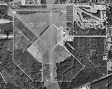
USGS aerial image as of 8 February 1998 IATA: DRI – ICAO: KDRI – FAA LID: DRI Summary Airport type Public Owner Beauregard Parish Serves De Ridder, Louisiana Location Beauregard Parish, near De Ridder, Louisiana Elevation AMSL 202 ft / 62 m Coordinates 30°49′54″N 093°20′24″W / 30.83167°N 93.34°W Runways Direction Length Surface ft m 14/32 4,220 1,286 Asphalt 18/36 5,495 1,675 Asphalt/Concrete Statistics (2008) Aircraft operations 14,400 Based aircraft 21 Source: Federal Aviation Administration[1] 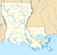
 Beauregard RAPLocation of Beauregard Regional Airport, Louisiana
Beauregard Regional Airport (IATA: DRI, ICAO: KDRI, FAA LID: DRI) is a public use airport in Beauregard Parish, Louisiana, United States. It is owned by Beauregard Parish and is located three nautical miles (6 km) southwest of the central business district of De Ridder, Louisiana.[1] The airport serves the general aviation community, with no scheduled commercial airline service.
Contents
History
Origins
The present Beauregard Regional Airport has a long and colorful history, which began prior to its use as an airfield. The airport property includes most of what was once the Graybow Community. In 1912 Graybow was an active community and the location of the Galloway Sawmill.
The sawmill had been built along the Santa Fe Railroad tracks with the planer mill on one side of the tracks and the big mill, commissary, and office on the other side of the tracks.
Two decades later the nation was experiencing the effects of the Great Depression. To counteract the unemployment caused by the depression, work projects were activated across the country. One such project was begun in 1934, 3 miles (4.8 km) west of DeRidder under the Auspices of the Emergency Relief Authority which later became the WPA. This project in a stump littered field provided employment for about 400 men, who worked to clear what had once been a densely wooded region. They constructed two earthen runways on 160 acres (0.65 km2) of land leased from the owner. The field was used very little. Barnstorming pilots would occasionally visit and offer rides for $2.00.
World War II
Interest in the military utilization of the airfield increased significantly in 1939 when war began in Europe. The United States needed a training ground for American troops. In the summer of 1940 and throughout 1941 the area was used for the "Louisiana Maneuvers".
The Beauregard Parish Police Jury bought the previously leased 160 acres (0.65 km2) plus an additional 280 acres (1.1 km2) for $11,000. An additional 200 acres (0.81 km2) was later bought to make up 1-square-mile (2.6 km2). In February, 1941, the United States Army Corps of Engineers visited the site urging that a proposed development be filed as a National Defense Project. The Police Jury and the City of DeRidder agreed to furnish the additional 200 acres (0.81 km2), plus sewage and water facilities, and to remove obstructions to air navigation. The cost to be $475,518.85 excluding labor. On 1 July 1941, a contract for Lease was signed between the Beauregard Parish Police Jury and the United States Army Air Force for a military airfield to be built on the site.
An immediate construction program began to convert the civilian airport into a military airfield and support complex. Construction involved runways and airplane hangars, with three concrete runways, several taxiways and a large parking apron and a control tower. Several large hangars were also constructed. Buildings were ultimately utilitarian and quickly assembled. Most base buildings, not meant for long-term use, were constructed of temporary or semi-permanent materials. Although some hangars had steel frames and the occasional brick or tile brick building could be seen, most support buildings sat on concrete foundations but were of frame construction clad in little more than plywood and tarpaper. During the war years, the base had what was needed for the welfare of the men: a post exchange, library, chapel, finance building, orderly rooms, headquarters sub-depot, officers and enlisted men's clubs, hospital, theater, swimming pool, shooting range, bowling and billiards.
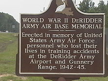
Just before Christmas 1941, the first troops arrived at the DeRidder Army Airbase. It housed anywhere from 3000 to 5000 troops at a time. The airfield was assigned to Third Air Force as a training airfield.
Initial training was performed by the III Reconnaissance Command, for reconnaissance and observation units. Units assigned to the airfield were:
- 74th Reconnaissance Group, 10 April-13 December 1942
- 77th Reconnaissance Group, 25 July-28 September 1942
In late 1942, the airfield was reassigned to III Tactical Air Command which performed medium and light bomber tactical bomber training. Units assigned to DeRidder and the aircraft they trained on were:
- 321st Bombardment Group (Medium), 1 December 1942-31 January 1943 B-25 Mitchell
- 312th Bombardment Group (Dive), 20 February-13 April 1943 A-24 Banshee
- 417th Bombardment Group, 4 August-10 December 1943 A-20 Havoc
- 409th Bombardment Group, 10 December 1943-10 February 1944 A-20 Havoc
- 408th Fighter Group, 12 February-26 March 1944 P-40 Warhawk
on 31 March 1944, the II Tactical Air Division of III Tactical Air Command was assigned to DeRidder and conducted replacement training. Training ceased in February 1945 and the airfield was placed in reserve status. DeRidder Army Airbase was declared surplus on October 2, 1946 and transferred to War Assets Administration on April 30, 1947.

The Beauregard Parish Police Jury assumed responsibility for the airport that year. On December 23, 1948 the government deeded the base to the Police Jury under the terms of the Surplus Property Act.
Current use
A requirement of the deed was that the property had to remain a public airport and all benefits of the property must be used to benefit the airport. In this case the federal government, wisely, not only gave the parish an airport but also gave a means by which the airport could provide for its own financial self-support. Today the airport includes over 4,200 acres (17 km2) and is, financially, self-supporting.
The airport continues to host military exercises which include parachute jumps by Fort Polk personnel. Today it operates as the largest general aviation facility that is located in the state of Louisiana. The hangar area is essentially unchanged today except that the 75-foot (23 m) control tower has long since been removed and replaced by a metal light beacon tower.
The World War II hangar remains in use and the concrete vault of the Army Air Base Finance Office is located adjacent to the hangar. The vintage sewerage system is still utilized and contributed to a reduced construction cost for the Flight Service Station, a Federal Aviation Administration (FAA) facility completed in 1985.
Facilities and aircraft
Beauregard Regional Airport covers an area of 4,300 acres (1,700 ha) at an elevation of 202 feet (62 m) above mean sea level. It has two runways: 14/32 is 4,220 by 60 feet (1,286 x 18 m) with an asphalt surface; 18/36 is 5,495 by 100 feet (1,675 x 30 m) with an asphalt/concrete surface.[1]
For the 12-month period ending July 8, 2008, the airport had 14,400 aircraft operations, an average of 39 per day: 86% general aviation and 14% military. At that time there were 21 aircraft based at this airport: 81% single-engine and 19% multi-engine.[1]
See also
References
 This article incorporates public domain material from websites or documents of the Air Force Historical Research Agency.
- ^ a b c d FAA Airport Master Record for DRI (Form 5010 PDF), effective 2009-07-02.
- ^ This article incorporates public domain material from websites or documents of the Air Force Historical Research Agency.
- ^ Manning, Thomas A. (2005), History of Air Education and Training Command, 1942-2002. Office of History and Research, Headquarters, AETC, Randolph AFB, Texas ASIN: B000NYX3PC
External links
- FAA Terminal Procedures for DRI, effective 20 October 2011
- Resources for this airport:
- AirNav airport information for KDRI
- ASN accident history for DRI
- FlightAware airport information and live flight tracker
- NOAA/NWS latest weather observations
- SkyVector aeronautical chart, Terminal Procedures for KDRI
 USAAF Third Air Force in World War II
Airfields Group Training Stations · Replacement Training Stations · Tactical Airfields
Units Commands II Air Support Command · III Air Support Command · III Bomber Command · III Fighter Command · III Reconnaissance Command · III Tactical Air CommandDivisions III Tactical Air DivisionWings 8th Fighter Wing · 9th Fighter Wing · 40th Bombardment WingGroups Air Commando 2nd Air Commando · 3rd Air CommandoBombardment 3rd Bombardment · 12th Bombardment · 17th Bombardment · 21st Bombardment · 29th Bombardment · 30th Bombardment Group · 38th Bombardment · 44th Bombardment · 46th Bombardment · 47th Bombardment · 85th Bombardment · 88th Bombardment · 90th Bombardment · 91st Bombardment · 92nd Bombardment · 93rd Bombardment · 94th Bombardment · 95th Bombardment · 97th Bombardment · 98th Bombardment · 99th Bombardment · 100th Bombardment · 309th Bombardment · 310th Bombardment · 312th Bombardment · 319th Bombardment · 320th Bombardment · 321st Bombardment · 322d Bombardment · 323d Bombardment · 335th Bombardment · 336th Bombardment · 340th Bombardment · 344th Bombardment · 345th Bombardment · 386th Bombardment · 387th Bombardment · 391st Bombardment · 394th Bombardment · 396th Bombardment · 397th Bombardment · 409th Bombardment · 410th Bombardment · 411th Bombardment · 416th Bombardment · 417th Bombardment · 418th Bombardment · 451st Bombardment · 454th Bombardment · 463rd Bombardment · 483rd Bombardment · 488th BombardmentFighter 20th Fighter · 31st Fighter · 49th Fighter · 50th Fighter · 53rd Fighter · 54th Fighter · 56th Fighter · 59th Fighter · 79th Fighter · 80th Fighter · 81st Fighter · 84th Fighter · 85th Fighter · 311th Fighter · 332nd Fighter · 337th Fighter · 338th Fighter · 339th Fighter · 361st Fighter · 369th Fighter · 372nd Fighter · 404th Fighter · 405th Fighter · 408th Fighter · 414th Fighter · 506th FighterFighter-Bomber 27th Fighter-Bomber · 48th Fighter-Bomber · 86th Fighter-Bomber · 406th Fighter-Bomber · 407th Fighter-BomberReconnaissance 2d Reconnaissance · 9th Reconnaissance · 10th Reconnaissance · 26th Reconnaissance · 65th Reconnaissance · 67th Reconnaissance · 68th Reconnaissance · 69th Reconnaissance · 70th Reconnaissance · 75th Reconnaissance · 77th Reconnaissance · 423d Reconnaissance · 424th Reconnaissance · 426th ReconnaissanceCategories:- 1934 establishments
- USAAF Third Air Force Group Training Stations
- USAAF Third Air Force Replacement Training Stations
- Airports in Louisiana
- Airfields of the United States Army Air Forces in Louisiana
- Buildings and structures in Beauregard Parish, Louisiana


Wikimedia Foundation. 2010.