- Tamsui District
-
Tamsui District
淡水區— District — Lovers Bridge Location of Tamsui in New Taipei
Coordinates: 25°00′40″N 121°26′45″E / 25.01111°N 121.44583°E Country  Republic of China (Taiwan)
Special municipality New Taipei Time zone +8 Tamsui District Traditional Chinese 淡水區 Simplified Chinese 淡水区 Transcriptions Mandarin - Hanyu Pinyin Dànshuǐ Qū - Tongyong Pinyin Dànshueǐ Cyu Min - Hokkien POJ Tām-súi Khu Tamsui District (淡水區, formerly Danshui District, also spelled Danshuei District) is a sea-side district in New Taipei City in northern Taiwan (ROC). It is named after the Tamsui River; the name means "fresh water". The town is popular as a site for viewing the sun setting into the Taiwan Strait. Though modest in size (population 130,105), the district is home to three universities (Aletheia University, Tamkang University, and St. John's University) and has a large role in Taiwanese culture.
Contents
History
Names
Originally settled by the Ketagalan aborigines, the location was called Hoba, meaning "stream's mouth". Hoba was loaned into Taiwanese as Hō·-bé (滬尾). Historical records in English may refer to the place as "Hobe". The Spanish arrived in the 17th century and called this place Casidor and the Tamsui River Kimalon. Until the 25 December 2010 creation of New Taipei, Tamsui was an urban township (淡水鎮; Dànshuǐ Qū; Tām-súi-tìn; Postal map spelling: Tamsui) in the former Taipei County. The name "Danshui," formerly used by the Taiwan government, Taipei Metro, and other sources, is based on the Mandarin Chinese pronunciation, using the Hanyu Pinyin transliteration system. Meanwhile, the name "Tamsui" is based on the Taiwanese language pronunciation. Having long used "Tamsui" as the official English name, the local government of the district informed the national government in 2011 that "Tamsui" rather than "Danshui" should be used in English.
Colonial period
The Spanish arrived in the area of Tamsui in the 17th century. In the fall of 1629, the Spanish established the first major non-aboriginal settlement comprising the town and mission of Santo Domingo. The Spanish occupied northern Taiwan for the purpose of securing Spanish interests in the Philippines against the Dutch (who were already established in the South of Taiwan by then), the British, and the Portuguese, as well as for facilitating trade with China and Japan.
In 1641, the Spanish were expelled from Taiwan by the Dutch. The Spanish had already abandoned their settlement in Tamsui in 1638 and the Dutch built a new fort which they named Fort Anthonio (after the Governor-General of the Dutch East India Company Anthonio van Diemen). It is today known as Hongmao Cheng (ch: 紅毛城, literally, the Fortress of the Red-haired ones) and is the main building of the Fort San Domingo museum complex. In addition to "pacifying" the aboriginal tribes in the area, the Dutch also encouraged the immigration and settlement of the area by Han Chinese, as well as expanding the production and trade of sulfur, animal skins, and other indigenous resources.
The Dutch left Taiwan in 1661 following their defeat by Koxinga, who continued the policy of increasing Han Chinese immigration until the defeat of his descendants by the Qing Dynasty.
Because of its proximity to mainland China, as well as its location in a natural harbor, Tamsui quickly became a major fishing and trade port. The Qing naval patrol also established an outpost in Tamsui in 1808. In 1862, the Qing government opened Tamsui to foreign trade under the terms of the Treaty of Tientsin, exporting tea, camphor, sulfur, coal, opium, and dyes. By the mid-19th century Tamsui had become the largest port in Taiwan, boasting a sizable foreign population as well as a British consulate at Hong Mao Cheng.[1]
Canadian medical doctor and missionary George Leslie Mackay arrived in Tamsui on March 9, 1872, proceeding to establish Taiwan's first hospitals in Western medicine and formal educational facilities, including Oxford College (now part of Aletheia University), the oldest higher-education institution in Taiwan by some measure.
In 1884, the harbour of Tamsui was blockaded by the French Navy under the command of Admiral Amédée Courbet, during the Sino-French War.[2]
By the time Taiwan was ceded to Japan following the end of the Sino-Japanese War, Tamsui's position as a seaport was beginning to wane due to the accumulation of sediments in the Tamsui River. By the 20th century, most of Tamsui's port operations had moved to Keelung, and the local economy had switched primarily to agriculture. However, public infrastructure construction projects by the Japanese led to Tamsui's rise as a local administrative and cultural center.
Contemporary history
Following the end of World War II, Tamsui reverted to being a small fishing town. With the expansion of nearby Taipei City, Tamsui slowly became a center for tourism along Taiwan's northwest coast. In the last ten years, the city has become popular as a suburb of Taipei in the local real estate market.
Following the completion of the Taipei Metro's Tamsui Line, the town experienced a sharp increase in tourist traffic, reflected in the completion of several riverside parks, the growth of open-air markets specializing in traditional handicrafts and street-stall snacks, the construction of a fisherman's wharf, and the increase in passenger ferries traversing across and along the river.
Sister city
 - Chico, California (U.S.) 2005[3]
Gallery
-

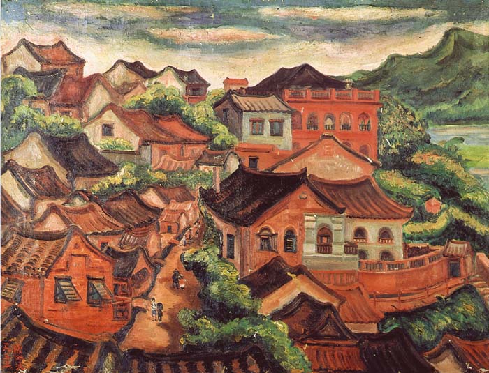
Tamsui/ Chen Cheng-po/ 1935/ 91 x 116.5 cm/ Collection from Taiwan Museum of Fine Arts
-

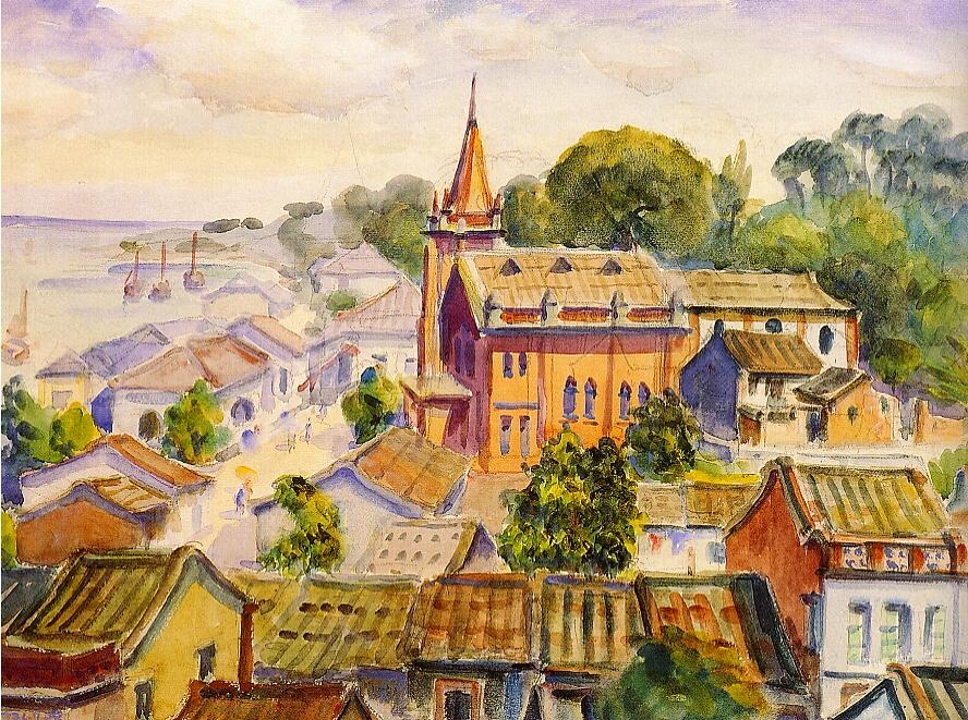
Tamsui/Tamsui Church/ Ni Chiang-huai/ 1936/ Paper/ Watercolor/ 49.5×66cm/ Collection of Taipei Museum of Fine Arts
-
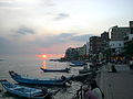
Tamsui waterfront at sunset
Sources
- History section retrieved and translated from Tamsui District official website.
Notes
- ^ The consulate was closed on 13 March 1972 and returned to the authorities in 1980. See Sino-British relations.
- ^ Elleman, Bruce A. Modern Chinese Warfare, 1795-1989 Routledge ISBN 0415214734, p.89 [1]
- ^ http://www.newsreview.com/chico/Content?oid=oid%3A43367 Chico gets a Southern sister
External links
- Tamsui District official website (English version)
- Tamsui travel guide from Wikitravel
- Blog groups of Tamsui, Huwei Culture Workshop
- Tamsui Historic Sites exhibition
- Takao Club: The Tamsui Foreign Cemetery
- Tamsui District Office: Art and Culture
Districts of New Taipei City seat: Banqiao Northern Bali · Jinshan · Linkou · Sanzhi · Shimen · Tamsui · Wanli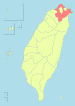
Eastern Gongliao · Pinglin · Pingxi · Ruifang · Shenkeng · Shiding · Shuangxi · XizhiWestern Banqiao · Luzhou · Sanchong · Shulin · Taishan · Tucheng · Wugu · Xinzhuang · Yingge · Yonghe · ZhongheSouthern Sanxia · Wulai · XindianNote: Although Hanyu Pinyin is the national standard, the municipal government endorses and uses "New Taipei" instead of "Xinbei" and "Tamsui" instead of "Danshui". Categories:- History of New Taipei
- Districts of New Taipei


Wikimedia Foundation. 2010.