- Dagenham
-
Coordinates: 51°32′23″N 0°08′32″E / 51.5397°N 0.1422°E
Dagenham 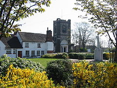
The parish church formed the heart of the former village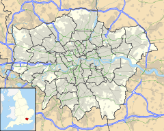
 Dagenham
Dagenham shown within Greater LondonOS grid reference TQ485845 - Charing Cross 12 mi (19 km) W London borough Barking & Dagenham Ceremonial county Greater London Region London Country England Sovereign state United Kingdom Post town DAGENHAM Postcode district RM8, RM9, RM10 Dialling code 020 Police Metropolitan Fire London Ambulance London EU Parliament London UK Parliament Dagenham and Rainham London Assembly City and East List of places: UK • England • London Dagenham is a large suburb in East London, forming the eastern part of the London Borough of Barking and Dagenham and located 12 miles (19.3 km) east of Charing Cross. It was historically an agrarian village in the county of Essex and remained mostly undeveloped until 1921 when the London County Council began construction of the large Becontree estate. The population of the area significantly increased during the 20th century, with the parish of Dagenham becoming an urban district in 1926 and a municipal borough in 1938. It has formed part of Greater London since 1965 and is a predominantly residential area, with some areas of declining industrial activity, including the Ford Dagenham plant. The population is set to rise as the southern part of Dagenham, adjacent to the River Thames, forms part of the London Riverside section of the Thames Gateway redevelopment area.
Contents
History
Dagenham (parish) population 1881 3,411 1891 4,324 1901 6,091 1911 7,930 1921 9,127 1931 89,362 1941 war # 1951 114,568 1961 108,368 # no census was held due to war source: UK census Toponomy
Dagenham first appeared in a document (as Dæccanhaam) in a charter of Barking Abbey dating from 686 AD. The almost certainly originated with a small farmstead, the "ham" or farm of a man called Daecca, as Dæccan hamm in Old English means home of a man called Dæcca.[1]
Economic development
 Ford Dagenham Terminal
In 1931 the Ford Motor Company relocated from Trafford Park in Stretford, to a plant in Dagenham, which was already the location of supplier Briggs Motor Bodies. A 500 acre (2 km²) riverside site was developed to become Europe's largest car plant, a vast vertically integrated site with its own blast furnaces and power station, importing iron ore and exporting finished vehicles. By the 1950s Ford had taken over Briggs at Dagenham and its other sites at Doncaster, Southampton, Croydon and Romford. At its peak the Dagenham plant had 4 million square feet (371600 m²) of floor space and employed 40,000.[2] On February 20, 2002, full production was discontinued due to overcapacity in Europe and the relative difficulty of upgrading the 60 year old site compared with other European sites such as Almussafes, Valencia, Spain and Cologne. Other factors leading to the closure of the Auto-assembly line were the need of the site for the new Diesel Centre of Excellence, which produces half of Ford's Diesel Engines worldwide and the UK employment laws when compared to Spanish, German and Belgian laws. In 2005 Cummins went into a joint venture and offered $15 million (US) to reinstate the factory. Ford and Cummins offered a good redundancy package, billed as one of the best in UK manufacturing. It is the location of the Dagenham wind turbines.[3] Some 4,000 people now work at the Ford plant.[4] The movie Made in Dagenham (2010) is a dramatisation of the 1968 Ford sewing machinists strike at the plant, where female workers walked out in protest against sexual discrimination and the desire for equal pay.
Sterling Ltd who were famous for manufacturing British Army weapons and Jaguar car parts were also based in Dagenham until they went bankrupt in 1988. Other industrial names once known world wide were Ever Ready, whose batteries could be found in shops throughout the Commonwealth, Bergers Paint and the chemical firm of May and Baker who in 1935 revolutionized the production of antibiotics with their synthetic sulfa-drug known as M&B 693. The May & Baker plant, now owned and run by Sanofi-Aventis, occupies a large site near to Dagenham East station, and its sports and social club has large grounds between Eastbrookend Country Park and the railway. In 2009 the company announced its intention to close the plant by 2013.
Local government
Dagenham was an ancient, and later civil, parish in the Becontree hundred of Essex.[5] The Metropolitan Police District was extended to include Dagenham in 1840. The parish formed part of the Romford Rural District from 1894.[6][7] The expansion of the Greater London conurbation into the area caused the review of local government structures and it was suggested in 1920 that the Dagenham parish should be abolished and its area divided between Ilford Urban District and Barking Town Urban District.[8] Separately, the London County Council proposed that its area of responsibility should be expanded beyond the County of London to cover the area.[9] Instead, in 1926 the Dagenham parish was removed from the Romford Rural District and became an urban district.[6] In 1938, in further recognition of its development, Dagenham became a municipal borough.[10] In 1965 the Municipal Borough of Dagenham was abolished and its former area became part of the London Borough of Barking,[11] which is now known as Barking and Dagenham.[12]
Market gardens to suburban estate
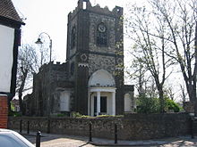 Dagenham parish church
In 1205 Dagenham was large enough to have a chaplain and the Parish Church of St Peter and St Paul was probably built at around that time.[13] In 1854, a station was opened on the London, Tilbury and Southend Railway in the south of Dagenham, near the Thames, at Dagenham Dock. In 1885 a new direct route from Barking to Pitsea, via Upminster, was built with a new station opened just north of the village. Dagenham was still an undeveloped village, when building of the vast Becontree estate by the London County Council began in the early 1920s.[14] The building of the enormous council estate, which also spread into the neighbouring parishes of Ilford and Barking,[8] caused a rapid increase in population.[15] In 1932 the electrified District Line of the London Underground was extended to Upminster through Dagenham with stations opened as Dagenham and Heathway and today called Dagenham East and Dagenham Heathway.[16] Dagenham East was the location of the Dagenham East rail crash in 1958.[17] Services on the London Tilbury & Southend line at Dagenham East were withdrawn in 1962.
Governance
Dagenham is part of the Dagenham and Rainham parliamentary constituency and the London Assembly constituency of City and East.
Geography
 River Beam in the south of Dagenham
Dagenham Dock, to the south of Dagenham and adjacent to the River Thames, was once a large coaling port. The area now forms part of the London Riverside section of the Thames Gateway redevelopment zone. Major brownfield housing developments are forecast to increase the population by tens of thousands of people. The Roundhouse public house on the junction of Porters Avenue and Lodge Avenue became East London's premier rock music venue between 1969 and 1975. Incorporating the "Village Blues Club", some notable bands who performed at the pub were Jethro Tull, Supertramp, Queen, Pink Floyd, Eric Clapton, Status Quo, and Led Zeppelin (on 5 April 1969).
Demography
Dagenham is a predominantly white, working class area.[18] At the last census in 2001, around 85% of the population was "white", with 80% being classed as "white: British". The remaining 20% of the population were primarily other European nationalities (5%), Black (7%) and Asian (5%) populations.[19]
Transport
There are London Underground services from Becontree, Dagenham East and Dagenham Heathway. c2c currently operate the National Rail service from Dagenham Dock.[20] National Rail services also operate from nearby Chadwell Heath. Dagenham Heathway is served by the following Transport for London contracted routes: London Buses route 145,173,174,175 and 364.[21]
Culture
 The southern Dagenham skyline includes structures of the Ford plant and wind turbines
Valence House is in Becontree Avenue. It is the only surviving of the five manor houses of Dagenham.[22] Dating back to the 13th century it is sited in parkland and is partially surrounded by a moat. Valence House is the borough's local history museum and art gallery, displaying an impressive collection of artifacts and archives that tell the story of the lives of the people of Barking and Dagenham. The collection also includes portraits, family papers and other mementoes of the Fanshawe family, who occupied Parsloes Manor, since demolished, from the sixteenth century.[23] The Fanshawe collection is "one of the best collections of gentry portraits in the country and is of international importance," according to Valence House.[24] Among members of the Fanshawe family was the diplomat Sir Richard Fanshawe, 1st Baronet, whose portrait is at Valence House. Nine successive members of the Fanshawe family served as Remembrancer to the Crown, following Henry Fanshawe's appointment to the position by Queen Elizabeth I in 1566. The appointment made possible the family's rise to prominence.
On the corner of Whalebone Lane and the Eastern Avenue, diagonally opposite the Moby-Dick public house, is the site of a Saxon moot hall. The adjoining fields were used during World War II by the Royal Artillery as an anti-aircraft battery before being converted into a Prisoner of War camp for Germans. Further south down Whalebone Lane on the corner of the High Road is the Tollgate pub. This stands on the site of the milestone which marked the ten mile (16 km) limit from the City of London and the turnpike toll-gate.
Sport
Dagenham & Redbridge F.C., based in Dagenham, are currently playing in the Football League Two having been promoted as playoff-winners of League two after beating Rotherham United F.C. 3-2. Priot to this, they were the Nationwide Conference champions in the 2006/7 season. They play at the London Borough of Barking & Dagenham Stadium, on Victoria Road.
Motorcycle speedway was staged at the greyhound stadium in Ripple Road in the mid to late 1930s. The club run events focussed on training but a team called the Dagenham Daggers did take part in local competitions. It is possible that the venture was operational as early as 1931 a meeting at Caxton (Cambridgeshire) was advertised as Caxton Speedway v Dagenham Speedway.
Dagenham has a King George's Field in memorial to King George V. The park, which has been in existence for over a century, was renamed in 1953 by Queen Elizabeth II. Dagenham also has many other parks such as Valence and Parsloes. Dagenham Crusaders Drum and Bugle Corps, founded by John Johnson, were the first British Drum Corps and performed in America for the first time in 1983. They have recently reformed to perform for DCUK's 30th anniversary, and in 2010 are fielding a competitive corps for the first time in 22 years.
The town is also home to the Dagenham Girl Pipers, a bagpipe marching band founded in 1930 by the Rev Joseph Waddington Graves.
Notable people
Main article: List of people from Barking and DagenhamOne of the longest-serving vicars of Dagenham was Rev. Abraham Blackborne, who died at age 82 in 1797, having served Dagenham for 58 years.[25][26] Rev. Blackborne was the grandson of Sir Richard Levett, Lord Mayor of London and was married to Frances Fanshawe of Parsloes Manor in Dagenham. Rev. Blackborne and his wife are buried at Saint Anne's Church, Kew.[27] The Blackborne family had long lived in Dagenham and Hornchurch.[28] At the time of the Restoration, the entire manor of Cockermouth, to which the church was appended, was owned by Sir Thomas Darcy. Subsequently the manor was sold to the Blackborne family, and ultimately the heirs of William Blackborne Esq., High Sheriff of Essex, sold to the Bonynges[29] after Blackborne suffered devastating financial losses in the South Sea Bubble.[30] St Peter and Paul's Church in Dagenham was once the Parish Church of the former Archbishop of Canterbury, George Carey.
Musician and comedian Dudley Moore was brought up in Dagenham,[31] which was the home of Peter Cook and Dudley Moore's famous comic alter-egos Pete and Dud.[32]
References
- Notes
- ^ Mills 2001, p. 64
- ^ Ford UK - History of Ford in Britain
- ^ Greater London Authority - Wind Turbines, Ford Estate, Dagenham planning application. 4 June 2003.
- ^ [1]
- ^ British History Online - The Hundred of Becontree
- ^ a b Vision of Britain - Dagenham parish (historic map)
- ^ Vision of Britain - Romford RD (historic map)
- ^ a b British History Online - The borough of Barking. Date accessed: 5 May 2007.
- ^ Greater London: Case for Central Authority: Area and Powers. The Times. December 14, 1921.
- ^ Vision of Britain - Dagenham MB
- ^ Vision of Britain - Barking LB
- ^ Barking and Dagenham London Borough Council - The Mayor
- ^ "Old Dagenham Village". Heritage and History. Barking and Dagenham London Borough Council. http://www.barking-dagenham.gov.uk/4-heritage/dag-village/dvil-main-menu.html.
- ^ Olechnowicz, A., Working-Class Housing in England Between the Wars: The Becontree Estate (1997)
- ^ Vision of Britain - Dagenham population
- ^ Rose, D., The London Underground: A diagrammatic history, (1999)
- ^ Railways Archive - Report on the collision at Dagenham East - 30.01.58
- ^ Asthana, Anushka (2010-03-21). "Dagenham's heyday: 'It was all just one big happy family then'". The Observer: pp. 18–19. http://www.guardian.co.uk/society/2010/mar/21/dagenham-barking-ford-industrial-history. Retrieved 2010-03-23.
- ^ "Ethnic Group (UV09) (Barking and Dagenham (Local Authority))". United Kingdom Census 2001. Office for National Statistics. 18 November 2004 (last updated). http://neighbourhood.statistics.gov.uk/dissemination/LeadTableView.do?a=7&b=276744&c=dagenham&d=13&e=16&g=325594&i=1001x1003x1004&m=0&r=1&s=1243289142958&enc=1&dsFamilyId=87. Retrieved June 2, 2010.
- ^ c2c - Stations and route map
- ^ Transport for London - Buses from Dagenham Heathway
- ^ Valence House museum
- ^ The Fanshawe Family, London Borough of Barking and Dagenham, barking-dagenham.gov.uk
- ^ The History of Essex: From the Earliest Period to the Present Time, Elizabeth Ogborne, Printed for the Proprietors and sold by R.H. Kelham, London, 1814
- ^ Blackburne, Abraham in Venn, J. & J. A., Alumni Cantabrigienses, Cambridge University Press, 10 vols, 1922–1958.
- ^ Rev. Blackborne also served a parish in Middlesex, where he and his wife Frances (nee Fanshawe) had the use of an estate in St. Martin-in-the-Fields, according to their deed of 1791.[2]
- ^ Miscellanea Genealogica et Heraldica, Vol. II, Joseph Jackson Howard. F.S.A., Hamilton, Adams, and Co., London, 1876
- ^ This Blackborne family is undoubtedly related to Robert Blackborne, Samuel Pepys's good friend, who was Secretary of the Admiralty, and later Secretary of the original East India Company.
- ^ The History of Essex: From the Earliest Period to the Present Time, Elizabeth Ogborne, Printed for the Proprietors by R.H. Kelham, London, 1814
- ^ Shawcross, John Peter (1908). A History of Dagenham in the County of Essex. London: Skeffington and Son. http://books.google.com/books?id=bHYfAQAAMAAJ&pg=PA318-IA3&lpg=PA318-IA3&dq=%22william+blackborne%22+high+sheriff#v=onepage&q=%22william%20blackborne%22%20high%20sheriff&f=false.
- ^ Parkinson, David (January 2011). "Moore, Dudley Stuart John (1935–2002)". Oxford Dictionary of National Biography. Online ed. Oxford: OUP.
- ^ Cook, Peter; Moore, Dudley (2003). Dud and Pete The Dagenham Dialogues. Methuen. ISBN 978-0-413-77347-0..
- Bibliography
- Mills, A.D. (2001), Dictionary of London Place Names, Oxford, ISBN 0192801066
- Powell, W.R. (Edr.) (1966), Dagenham, A History of the County of Essex: Volume 5, Victoria County History, British History Online, http://www.british-history.ac.uk/report.aspx?compid=42731, retrieved 2009-11-01
London Borough of Barking and Dagenham Districts Barking · Becontree · Becontree Heath · Castle Green · Chadwell Heath · Creekmouth · Dagenham · Dagenham Dock · Marks Gate · Rush Green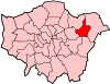
Attractions Barking Abbey · Barking Market · Eastbury Manor House (NT) · Valence House Museum · The Broadway · Victoria RoadParks and open spaces Barking Park · Central Park · Eastbrookend Country Park · Mayesbrook Park · Parsloes Park · Valence ParkConstituencies Tube and rail stations Other topics Categories:- Districts of London
- Vehicle manufacture in London
- Districts of Barking and Dagenham


![[2]](http://library.mcmaster.ca/archives/images/bli/bli-71r.jpg)
Wikimedia Foundation. 2010.