- Marlow Bottom
-
Coordinates: 51°35′24″N 0°46′54″W / 51.5901°N 0.7816°W
Marlow Bottom 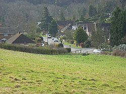
Marlow Bottom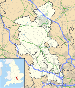
 Marlow Bottom
Marlow Bottom shown within BuckinghamshireOS grid reference SU845885 Parish Marlow Bottom District Wycombe Shire county Buckinghamshire Region South East Country England Sovereign state United Kingdom Post town MARLOW Postcode district SL7 Dialling code 01628 Police Thames Valley Fire Buckinghamshire Ambulance South Central EU Parliament South East England UK Parliament Wycombe List of places: UK • England • Buckinghamshire Marlow Bottom is a large linear village occupying a valley to the north of Marlow, Buckinghamshire. It is also a civil parish in Wycombe district having been created in November 2007. Formerly it was part of the parish of Great Marlow.
Marlow Bottom is 25 to 30 minutes walk from the centre of Marlow town, and the river Thames. It has shops, including a newsagent, vet, butcher, chemist, off-licence, dog grooming parlour and a fish & chip shop, a large primary school, (Burford School), a private members club (The Barn Club, for valley residents), a village hall and two small churches (Anglican and Methodist) which form a Local Ecumenical Partnership "The Valley Church", where the local Boy Scout and Girl Guide groups and similar voluntary groups meet. Marlow Bottom is also home to the Rebellion Beer Company, an award winning local brewery producing regular and seasonal beers.
Contents
Burford County Combined School
The primary school in Marlow Bottom is Burford County Combined School. It provides schooling for children aged 4–11, who will go on to either a local grammar school or secondary modern school depending on their results in the 11+ exam.
The vast majority of students who attend Burford School live in the village although the school does accept students from outside.
At present the school accommodates more than 420 pupils. The main school building comprises classrooms, work areas, a main hall, an information and communication technology (ICT) room and administrative offices. During 2001/02 two new classrooms were built. A new building that houses the library and music rooms was completed during the summer holidays. In September a new computer network was installed in the refurbished ICT room.
The school is one of the most successful orienteering centres for children aged between 9 and 11 in the UK. The school's team, headed until his retirement in 2008 by Year 6 teacher Mr. Vyner, has won many British Schools Orienteering Championships in the past 10 years, with children of both genders frequently winning whole events.[1]
Points of interest
Steve Redgrave lives in the village, and the original fungus from which Quorn was made was found in a field nearby (Quorn is still manufactured by the company Marlow Foods). Marlow Bottom villagers meet annually in the summer for the Rose Carnival, a local celebration and fundraiser. The 'Rose Carnival Queen', is chosen from a selection of pupils at Burford School, who enter a competition to win the title.
References
External links
- Marlow Bottom Parish Council
- Burford school's website
- Burford School profile at Directgov
- Marlow Bottom Methodist Church – part of The Valley Church
- St Mary the Virgin Church, Marlow Bottom – part of The Valley Church
- The Valley Church
- Rebellion Beer Company
- Rose Carnival
- The Barn Club
- The Village Hall
- Marlow Bottom Valley Residents Association
- Marlow Bottom Playing Fields
Categories:- Villages in Buckinghamshire
- Civil parishes in Buckinghamshire


Wikimedia Foundation. 2010.