- Mount Mee, Queensland
-
Mount Mee
Queensland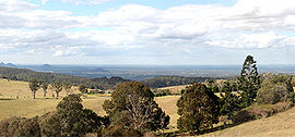
Population: 399[1] Established: 1873 Postcode: 4521 Coordinates: 27°4′27″S 152°46′11″E / 27.07417°S 152.76972°ECoordinates: 27°4′27″S 152°46′11″E / 27.07417°S 152.76972°E Elevation: 501 m (1,644 ft) Location: - 72 km (45 mi) from Brisbane CBD
- 27 km (17 mi) from Caboolture
LGA: Moreton Bay Region State District: Glasshouse Federal Division: Fisher Suburbs around Mount Mee: Mount Delaney Delaneys Creek Wamuran Basin Mount Mee Campbells Pocket Mount Byron Mount Pleasant Ocean View Mount Mee is a suburb and mountain in Queensland, Australia, located north of the town of Dayboro on the D'Aguilar Range.
Contents
History
The area around Mount Mee was known to the indigenous inhabitants of the area as Dahmongah, a word meaning "flying squirrel" or glider.[2] The European name "Mount Mee" is possibly derived from another local word mia-mia, meaning "lookout", but this name was not formalised until the establishment of the school in 1899.[3]
Settlers began arriving in the area around Mount Mee in 1873, many being timber-getters attracted by the red cedar timber that was readily available in the area.[2] Initially, timber cut down in the area was exported to the nearby towns of Caboolture, D'Aguilar and Woodford, but a sawmill was eventually built in the fledgling town. A number of larger mills were operated on various parts of the mountain until the last closed in 1982.[2] A special tractor called the Linn tractor was used to haul logs instead of bullock teams in the early 1930s.[2] Over time, agriculture became important to the economy of the area, with dairy farms and banana plantations being particularly important.[3][2]
Mount Mee was initially governed as a part of the Caboolture Divisional Board, but was rolled into the new Moreton Bay Region when that entity was amalgamated with Pine Rivers Shire and Redcliffe City in 2008.[4]
Demographics
At the 2006 census, the locality recorded a population of 399 persons, living in 142 inhabited dwellings, all of which were detached houses. The median age of the population was 40 years, 1% of the population spoke Slovene at home, and the median weekly household income was $793. 80.5% of the population was born in Australia, with the remainder coming from England (6.8%), Germany (1.3%), Venezuela (1.3%), Scotland (1%) and Slovenia (1%). Anglicans (21.6%) make up the largest single religious group in Mount Mee, followed by Catholics (15.8%) and Uniting Church (11.8%). 19.8% of people stated that they had no religion, according to the census.[1].
State Forest and Forest Reserve
Mount Mee State Forest and Forest Reserve is a nature preserve located in Mount Mee. It features eucalyptus forests, small sections of rainforest, and plantations of Hoop Pine.[5] They adjoin the Brisbane Forest Park. The park features six different walking tracks, two picnic grounds, a camping ground, and numerous tracks for offroad driving[6].
Education
Mount Mee State School, a government primary school that was founded in 1899, is located within the suburb.[3][7]
References
- ^ a b Australian Bureau of Statistics (25 October 2007). "Mount Mee (State Suburb)". 2006 Census QuickStats. http://www.censusdata.abs.gov.au/ABSNavigation/prenav/LocationSearch?collection=Census&period=2006&areacode=SSC36877&producttype=QuickStats&breadcrumb=PL&action=401. Retrieved 2008-05-03.
- ^ a b c d e Horton, Helen (1988). Brisbane's Back Door: The story of the D'Aguilar Range. Bowen Hills, Queensland: Boolarong Publications. pp. 64—71. ISBN 086439036 X.
- ^ a b c "Caboolture Town History". http://www.moretonbay.qld.gov.au/discover.aspx?id=348. Retrieved 2008-05-06.
- ^ "Amalgamations to cut half Qld's local councils". ABC News. 2007-07-27. http://www.abc.net.au/news/stories/2007/07/27/1990065.htm. Retrieved 2008-05-06.
- ^ "Mount Mee State Forest and Forest Reserve". Archived from the original on 2008-02-29. http://web.archive.org/web/20080229205000/http://www.epa.qld.gov.au/projects/park/index.cgi?parkid=63. Retrieved 2008-05-06.
- ^ "Mount Mee State Forest and Forest Reserve". Archived from the original on 2008-04-11. http://web.archive.org/web/20080411213700/http://www.epa.qld.gov.au/parks_and_forests/find_a_park_or_forest/mount_mee_state_forest_and_forest_reserve/#further_information. Retrieved 2008-05-06.
- ^ "Mount Mee State School". http://mtmeess.eq.edu.au. Retrieved 2008-05-06.
Categories:- Suburbs of Moreton Bay Region

Wikimedia Foundation. 2010.