- Mourne Wall
-
Coordinates: 54°08′20″N 6°00′11″W / 54.139°N 6.003°W
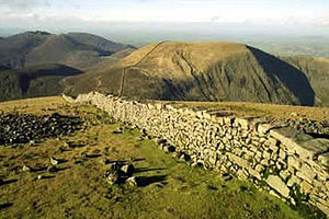 Mourne wall going down Slieve Donard
The Mourne Wall is a wall that was constructed to enclose a reservoir's catchment area in the Mourne Mountains, Northern Ireland. It was built between 1904 and 1922 by the Belfast Water Commissioners to enclose the water catchment in the Mournes.
The wall was crafted from natural granite stone using traditional dry stone walling techniques. On average the wall is about 1.5 metres (4 ft 11 in) high and 0.8 to 0.9 metre (2 ft 7 in to 2 ft 10 in) thick. It is 22 miles (35 km) long and passes over fifteen mountains (listed clockwise from the Kilkeel River):
- Slievenaglogh 445 m (1,460 ft)
- Slieve Muck 674 m (2,211 ft)
- Carn Mountain 587 m (1,926 ft)
- Slieve Loughshannagh 619 m (2,031 ft)
- Slieve Meelbeg 708 m (2,323 ft)
- Slieve Meelmore 684 m (2,244 ft)
- Slieve Bearnagh 727 m (2,385 ft)
- Slievenaglogh 586 m (1,923 ft)
- Slieve Corragh 691 m (2,267 ft)
- Slieve Commedagh 765 m (2,510 ft)
- Slieve Donard 850 m (2,790 ft)
- Rocky Mountain 525 m (1,722 ft)*
- Slieve Binnian 747 m (2,451 ft)
- Wee Binnian 460 m (1,510 ft)
- Moolieve 332 m (1,089 ft)
*Of those listed, Rocky Mountain is the only mountain where the Wall only skirts the lower slopes, rather than passing over or close by the summit.
The wall took eighteen years to complete. The Silent Valley Reservoir was created to hold the water in the catchment area, and supply Belfast with water. Some people argue that the wall was quite useless as it fences off about 9,000 acres (36 km2) of barren and desolate mountains. However, it brought a lot of very welcome employment at the time, and the main purpose of enclosing the area was to isolate the catchment area from the effects of cattle and sheep on the water course. It is currently owned and maintained by Northern Ireland Water.[1]
References
- ^ "The Mournes" Ordnance Survey of Northern Ireland, 2005
- The Mountains of Mourne, A Celebration of a Place Apart, David Kirk, 2002, Appletree Press Ltd, Belfast
External links
Categories:- Mountains and hills of County Down
- Walls in Northern Ireland
- Buildings and structures in County Down

Wikimedia Foundation. 2010.